![](/images/other/stat-length.png)
![Trail Walking Beuil - balcon sur les gorges du cians - Photo](https://media.geolcdn.com/t/1900/400/fbada1da-e007-46e1-8b66-10b993ce8c89.jpg&format=pjpeg&maxdim=2)
balcon sur les gorges du cians
pln30
User
![Length](/images/other/stat-length.png)
Length
10.2 km
![Max alt](https://static1.geolcdn.com/siteimages/upload/files/1508320355ic_sort_altitude_max_24dp.png)
Max alt
1640 m
![Uphill gradient](https://static1.geolcdn.com/siteimages/upload/files/1508320355ic_sort_den_pos_24dp.png)
Uphill gradient
457 m
![Km-Effort](/images/other/stat-length.png)
Km-Effort
16.3 km
![Min alt](https://static1.geolcdn.com/siteimages/upload/files/1508320355ic_sort_altitude_min_24dp.png)
Min alt
1251 m
![Downhill gradient](https://static1.geolcdn.com/siteimages/upload/files/1508320355ic_sort_den_neg_24dp.png)
Downhill gradient
460 m
![Boucle](https://static1.geolcdn.com/siteimages/upload/files/16400158638029165_repeat_loop_refresh_sync_direction_icon.png)
Boucle
Yes
Creation date :
2023-08-13 05:50:20.808
Updated on :
2023-08-13 11:31:22.145
![Walking](https://static1.geolcdn.com/sitytour/trail-icons/101.png)
3h16
Difficulty : Medium
![Scan this QR Code to open this trail in the SityTrail application](https://capi.geolives.com/qq0zvz2zws4bq2lad0pu/sitytour/trails/3769830/qr.png?size=200)
FREE GPS app for hiking
About
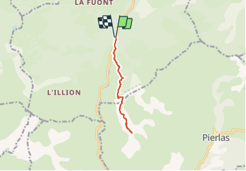
Trail Walking of 10.2 km to be discovered at Provence-Alpes-Côte d'Azur, Maritime Alps, Beuil. This trail is proposed by pln30.
Description
une promenade tout en couleur et tout en douceur.
vous pourrez retrouver la balade en drone sur ma chaîne youtube air view channel
Positioning
Country:
France
Region :
Provence-Alpes-Côte d'Azur
Department/Province :
Maritime Alps
Municipality :
Beuil
Location:
Unknown
Start:(Dec)
Start:(UTM)
338650 ; 4881351 (32T) N.
Comments
Trails nearby
![Trail Snowshoes Beuil - Beuil :Rando raquettes (Aller) - Photo](https://media.geolcdn.com/t/375/260/ext.jpg?maxdim=2&url=https%3A%2F%2Fservices.sitytrail.com%2FGeolivesWS%2FDownloadMedia.ashx%3FTrailID%3D251398%26Media%3Dfix__20140221123121.jpg)
![Snowshoes Snowshoes](https://static1.geolcdn.com/sitytour/trail-icons/504.png)
Beuil :Rando raquettes (Aller)
Snowshoes
Easy
(2)
Beuil,
Provence-Alpes-Côte d'Azur,
Maritime Alps,
France
![](/images/other/stat-length.png)
4.3 km | 6.6 km-effort
1h 40min
![](https://static1.geolcdn.com/siteimages/upload/files/16400158638029165_repeat_loop_refresh_sync_direction_icon.png)
No
![Trail On foot Guillaumes - Sentier Planétaire - Photo](https://media.geolcdn.com/t/375/260/e96398fb-c06d-4a8f-b157-fc349cbf3cc7.jpeg&format=jpg&maxdim=2)
![On foot On foot](https://static1.geolcdn.com/sitytour/trail-icons/100.png)
Sentier Planétaire
On foot
Easy
Guillaumes,
Provence-Alpes-Côte d'Azur,
Maritime Alps,
France
![](/images/other/stat-length.png)
9.2 km | 13 km-effort
2h 57min
![](https://static1.geolcdn.com/siteimages/upload/files/16400158638029165_repeat_loop_refresh_sync_direction_icon.png)
Yes
![Trail On foot Beuil - Tête du Garnier - Photo](https://media.geolcdn.com/t/375/260/8afc2979-1909-4f36-ba82-f331af4dab5f.jpeg&format=jpg&maxdim=2)
![On foot On foot](https://static1.geolcdn.com/sitytour/trail-icons/100.png)
Tête du Garnier
On foot
Easy
Beuil,
Provence-Alpes-Côte d'Azur,
Maritime Alps,
France
![](/images/other/stat-length.png)
11.2 km | 17.8 km-effort
4h 3min
![](https://static1.geolcdn.com/siteimages/upload/files/16400158638029165_repeat_loop_refresh_sync_direction_icon.png)
Yes
![Trail On foot Beuil - Corniches du Cians - Photo](https://media.geolcdn.com/t/375/260/df9224fd-ed5d-4e0e-98e6-95eb532acfaf.jpeg&format=jpg&maxdim=2)
![On foot On foot](https://static1.geolcdn.com/sitytour/trail-icons/100.png)
Corniches du Cians
On foot
Difficult
Beuil,
Provence-Alpes-Côte d'Azur,
Maritime Alps,
France
![](/images/other/stat-length.png)
18.3 km | 32 km-effort
7h 12min
![](https://static1.geolcdn.com/siteimages/upload/files/16400158638029165_repeat_loop_refresh_sync_direction_icon.png)
Yes
![Trail On foot Péone - Mont Mounier - Photo](https://media.geolcdn.com/t/375/260/0744a5ed-7dbe-4b82-ab9f-b5b91c9c9b14.jpeg&format=jpg&maxdim=2)
![On foot On foot](https://static1.geolcdn.com/sitytour/trail-icons/100.png)
Mont Mounier
On foot
Difficult
Péone,
Provence-Alpes-Côte d'Azur,
Maritime Alps,
France
![](/images/other/stat-length.png)
18.4 km | 34 km-effort
7h 41min
![](https://static1.geolcdn.com/siteimages/upload/files/16400158638029165_repeat_loop_refresh_sync_direction_icon.png)
Yes
![Trail On foot Pierlas - Tour du Mont de Lieuche - Photo](https://media.geolcdn.com/t/375/260/21b88e85-708c-4489-9ada-9348a7269087.jpeg&format=jpg&maxdim=2)
![On foot On foot](https://static1.geolcdn.com/sitytour/trail-icons/100.png)
Tour du Mont de Lieuche
On foot
Medium
Pierlas,
Provence-Alpes-Côte d'Azur,
Maritime Alps,
France
![](/images/other/stat-length.png)
12.2 km | 20 km-effort
4h 36min
![](https://static1.geolcdn.com/siteimages/upload/files/16400158638029165_repeat_loop_refresh_sync_direction_icon.png)
Yes
![Trail Walking Beuil - Gorges du Cians - AR sur les corniches - Photo](https://media.geolcdn.com/t/375/260/ext.jpg?maxdim=2&url=https%3A%2F%2Fservices.sitytrail.com%2FGeolivesWS%2FDownloadMedia.ashx%3FTrailID%3D348549%26Media%3Dfix__20140926113514.jpg)
![Walking Walking](https://static1.geolcdn.com/sitytour/trail-icons/101.png)
Gorges du Cians - AR sur les corniches
Walking
Medium
Beuil,
Provence-Alpes-Côte d'Azur,
Maritime Alps,
France
![](/images/other/stat-length.png)
12 km | 18.9 km-effort
4h 15min
![](https://static1.geolcdn.com/siteimages/upload/files/16400158638029165_repeat_loop_refresh_sync_direction_icon.png)
Yes
![Trail Snowshoes Roubion - Couillole Mt Brussière - Photo](https://media.geolcdn.com/t/375/260/ext.jpg?maxdim=2&url=https%3A%2F%2Fstatic1.geolcdn.com%2Fsiteimages%2Fupload%2Ffiles%2F1524743153raquette.jpg)
![Snowshoes Snowshoes](https://static1.geolcdn.com/sitytour/trail-icons/504.png)
Couillole Mt Brussière
Snowshoes
Easy
(2)
Roubion,
Provence-Alpes-Côte d'Azur,
Maritime Alps,
France
![](/images/other/stat-length.png)
5 km | 8.6 km-effort
2h 0min
![](https://static1.geolcdn.com/siteimages/upload/files/16400158638029165_repeat_loop_refresh_sync_direction_icon.png)
Yes
![Trail Walking Beuil - corniche du CIANS - Photo](https://media.geolcdn.com/t/375/260/ext.jpg?maxdim=2&url=https%3A%2F%2Fstatic1.geolcdn.com%2Fsiteimages%2Fupload%2Ffiles%2F1553511878bg_sport_marche.png)
![Walking Walking](https://static1.geolcdn.com/sitytour/trail-icons/101.png)
corniche du CIANS
Walking
Medium
(1)
Beuil,
Provence-Alpes-Côte d'Azur,
Maritime Alps,
France
![](/images/other/stat-length.png)
18.8 km | 32 km-effort
6h 35min
![](https://static1.geolcdn.com/siteimages/upload/files/16400158638029165_repeat_loop_refresh_sync_direction_icon.png)
Yes