![](/images/other/stat-length.png)
![Trail Walking Ceton - [Itinéraire] Le moulin aux Moines - Photo](https://media.geolcdn.com/t/1900/400/ext.pjpeg?maxdim=2&url=https%3A%2F%2Fstatic1.geolcdn.com%2Fsiteimages%2Fupload%2Ffiles%2F1553511878bg_sport_marche.png)
[Itinéraire] Le moulin aux Moines
ODDAD78
User
![Length](/images/other/stat-length.png)
![Max alt](https://static1.geolcdn.com/siteimages/upload/files/1508320355ic_sort_altitude_max_24dp.png)
![Uphill gradient](https://static1.geolcdn.com/siteimages/upload/files/1508320355ic_sort_den_pos_24dp.png)
![Km-Effort](/images/other/stat-length.png)
![Min alt](https://static1.geolcdn.com/siteimages/upload/files/1508320355ic_sort_altitude_min_24dp.png)
![Downhill gradient](https://static1.geolcdn.com/siteimages/upload/files/1508320355ic_sort_den_neg_24dp.png)
![Boucle](https://static1.geolcdn.com/siteimages/upload/files/16400158638029165_repeat_loop_refresh_sync_direction_icon.png)
![Walking](https://static1.geolcdn.com/sitytour/trail-icons/101.png)
1h17
Difficulty : Easy
![Scan this QR Code to open this trail in the SityTrail application](https://capi.geolives.com/qq0zvz2zws4bq2lad0pu/sitytour/trails/3768304/qr.png?size=200)
FREE GPS app for hiking
About
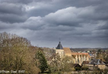
Trail Walking of 4.7 km to be discovered at Normandy, Orne, Ceton. This trail is proposed by ODDAD78.
Description
Se diriger vers le centre-bourg.
1. Entre les numéros 20 et 26 de la rue de l'église, tourner à droite et emprunter la ruelle qui va zigzaguer. Passer derrière la salle des fêtes (sur votre gauche) et prendre à droite l'allée menant à la piscine.
2. Juste après la passerelle, tourner à gauche et longer la rivière jusqu'à l'étang. Monter ensuite à gauche, après avoir remarqué un ancien lavoir, par un chemin empierré qui débouche sur la D 107.
3. Sur la D 107, prendre à droite, puis, à la sortie du bourg, se diriger à droite, vers l'Aitre et le moulin de Cohémont. Poursuivre en longeant le ruisseau.
4. Arrivé au chemin de l'Aitre on remarquera un bâtiment au toit brisé datant probablement du XVIIIème siècle (il s'agit là d'un type de couverture très rare dans le département de l'Orne). Poursuivre tout droit, par un chemin empierré, pour déboucher à La Bouillette. Prendre à droite la route du Loiret (C 101) en direction du bourg. Au carrefour, descendre par la rue de la Libération, puis prendre à gauche direction Avezé.
5. Après 150m s'engager à droite vers les Guittières (partie commune avec autre circuit). Arrivé au hameau, ignorer le chemin de droite, puis ignorer le suivant à gauche et poursuivre jusqu'au bout du chemin : le Vau Gelé, qui s'achève par un Y.
6. Descendre à droite par le petit sentier que l"on nomme "le moulin aux Moines" et continuer en prenant à droite. Franchir le pont de la Maroisse (avec petite chute d'eau) pour gagner la D 107, à la Croix Ste Anne. Traverser et prendre en face le chemin de la Petite Boussardière.
7. Monter en contournant cette ancienne ferme par la droite. Arrivé sur un chemin goudronné, tourner à droite et poursuivre tout droit jusqu'à la route.
8. Descendre à droite par la rue Jean Moulin, puis s'engager à gauche, dans la rue du Theil, puis tourner à droite, dans la rue des fontaines (vous passez devant un beau lavoir rénové) et enfin revenir à l'église par la rue à son nom !
(Pas à pas : Rando-Perche)
Positioning
Comments
Trails nearby
![Trail Walking Ceton - la maroisse - Photo](https://media.geolcdn.com/t/375/260/ext.jpg?maxdim=2&url=https%3A%2F%2Fstatic1.geolcdn.com%2Fsiteimages%2Fupload%2Ffiles%2F1553511878bg_sport_marche.png)
![Walking Walking](https://static1.geolcdn.com/sitytour/trail-icons/101.png)
![Trail Walking Ceton - Ceton : une version raccourcie du](https://media.geolcdn.com/t/375/260/64308962-e374-4e16-b6b0-14afb849fc8b.jpeg&format=jpg&maxdim=2)
![Walking Walking](https://static1.geolcdn.com/sitytour/trail-icons/101.png)
Walking
![](/images/other/stat-length.png)
![](https://static1.geolcdn.com/siteimages/upload/files/16400158638029165_repeat_loop_refresh_sync_direction_icon.png)
![Trail Walking Val-au-Perche - Le Theil-sur-Huisne (Val-au-Perche)-Saint-Germain-de-la-Coudre - 7,4 Km - Photo](https://media.geolcdn.com/t/375/260/967783d0-5fee-4d5b-8e1d-5bf2cfb3bd61.jpg&format=jpg&maxdim=2)
![Walking Walking](https://static1.geolcdn.com/sitytour/trail-icons/101.png)
Walking
![](/images/other/stat-length.png)
![](https://static1.geolcdn.com/siteimages/upload/files/16400158638029165_repeat_loop_refresh_sync_direction_icon.png)
![Trail Walking Val-au-Perche - Le Theil-sur-Huisne (Val-au-Perche) - Saint-Cyr-la-Rosière 11 km - Photo](https://media.geolcdn.com/t/375/260/e59b5058-f875-407e-8cb2-3a4748116412.jpg&format=jpg&maxdim=2)
![Walking Walking](https://static1.geolcdn.com/sitytour/trail-icons/101.png)
Walking
![](/images/other/stat-length.png)
![](https://static1.geolcdn.com/siteimages/upload/files/16400158638029165_repeat_loop_refresh_sync_direction_icon.png)
![Trail Walking Cherré-Au - Cherreau - Sur le sentier des lièvres - Photo](https://media.geolcdn.com/t/375/260/ext.jpg?maxdim=2&url=https%3A%2F%2Fservices.sitytrail.com%2FGeolivesWS%2FDownloadMedia.ashx%3FTrailID%3D110127%26Media%3D5321_1.jpg)
![Walking Walking](https://static1.geolcdn.com/sitytour/trail-icons/101.png)
Walking
![](/images/other/stat-length.png)
![](https://static1.geolcdn.com/siteimages/upload/files/16400158638029165_repeat_loop_refresh_sync_direction_icon.png)
![Trail Walking Ceton - [Itinéraire] Le prieuré St-Pierre-ès-Liens - Photo](https://media.geolcdn.com/t/375/260/ext.jpg?maxdim=2&url=https%3A%2F%2Fstatic1.geolcdn.com%2Fsiteimages%2Fupload%2Ffiles%2F1553511878bg_sport_marche.png)
![Walking Walking](https://static1.geolcdn.com/sitytour/trail-icons/101.png)
Walking
![](/images/other/stat-length.png)
![](https://static1.geolcdn.com/siteimages/upload/files/16400158638029165_repeat_loop_refresh_sync_direction_icon.png)
![Trail Walking Ceton - [Itinéraire] Le bois de Beauvais - Photo](https://media.geolcdn.com/t/375/260/ext.jpg?maxdim=2&url=https%3A%2F%2Fstatic1.geolcdn.com%2Fsiteimages%2Fupload%2Ffiles%2F1553511878bg_sport_marche.png)
![Walking Walking](https://static1.geolcdn.com/sitytour/trail-icons/101.png)
Walking
![](/images/other/stat-length.png)
![](https://static1.geolcdn.com/siteimages/upload/files/16400158638029165_repeat_loop_refresh_sync_direction_icon.png)
![Trail Walking Ceton - [Itinéraire] La petite forêt - Photo](https://media.geolcdn.com/t/375/260/ext.jpg?maxdim=2&url=https%3A%2F%2Fstatic1.geolcdn.com%2Fsiteimages%2Fupload%2Ffiles%2F1553511878bg_sport_marche.png)
![Walking Walking](https://static1.geolcdn.com/sitytour/trail-icons/101.png)
Walking
![](/images/other/stat-length.png)
![](https://static1.geolcdn.com/siteimages/upload/files/16400158638029165_repeat_loop_refresh_sync_direction_icon.png)
![Trail Walking Ceton - [Itinéraire] La boucle des Sorciers - Photo](https://media.geolcdn.com/t/375/260/ext.jpg?maxdim=2&url=https%3A%2F%2Fstatic1.geolcdn.com%2Fsiteimages%2Fupload%2Ffiles%2F1553511878bg_sport_marche.png)
![Walking Walking](https://static1.geolcdn.com/sitytour/trail-icons/101.png)
Walking
![](/images/other/stat-length.png)
![](https://static1.geolcdn.com/siteimages/upload/files/16400158638029165_repeat_loop_refresh_sync_direction_icon.png)