![](/images/other/stat-length.png)
![Trail Walking Ceton - [Itinéraire] La petite forêt - Photo](https://media.geolcdn.com/t/1900/400/ext.pjpeg?maxdim=2&url=https%3A%2F%2Fstatic1.geolcdn.com%2Fsiteimages%2Fupload%2Ffiles%2F1553511878bg_sport_marche.png)
[Itinéraire] La petite forêt
ODDAD78
User
![Length](/images/other/stat-length.png)
![Max alt](https://static1.geolcdn.com/siteimages/upload/files/1508320355ic_sort_altitude_max_24dp.png)
![Uphill gradient](https://static1.geolcdn.com/siteimages/upload/files/1508320355ic_sort_den_pos_24dp.png)
![Km-Effort](/images/other/stat-length.png)
![Min alt](https://static1.geolcdn.com/siteimages/upload/files/1508320355ic_sort_altitude_min_24dp.png)
![Downhill gradient](https://static1.geolcdn.com/siteimages/upload/files/1508320355ic_sort_den_neg_24dp.png)
![Boucle](https://static1.geolcdn.com/siteimages/upload/files/16400158638029165_repeat_loop_refresh_sync_direction_icon.png)
![Walking](https://static1.geolcdn.com/sitytour/trail-icons/101.png)
2h01
Difficulty : Medium
![Scan this QR Code to open this trail in the SityTrail application](https://capi.geolives.com/qq0zvz2zws4bq2lad0pu/sitytour/trails/3766622/qr.png?size=200)
FREE GPS app for hiking
About
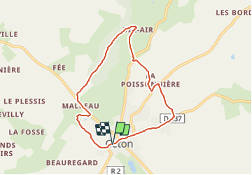
Trail Walking of 6.9 km to be discovered at Normandy, Orne, Ceton. This trail is proposed by ODDAD78.
Description
Départ : Ceton Arrivée : Ceton Balisage : PR Communes : 1. Ceton
Prendre la direction d'Avezé sur 150m puis prendre à droite, dans le chemin goudronné, vers les Guittières (partie commune avec autre circuit). Arrivé au hameau, ignorer le chemin de droite, puis ignorer le suivant à gauche et poursuivre jusqu'au bout du chemin : le Vau Gelé, qui s'achève par un Y.
1. Descendre à droite par le petit sentier que l"on nomme "le moulin aux Moines" et continuer en prenant à droite. Franchir le pont de la Maroisse : petite chute d'eau pour gagner la D 107, à la Croix Ste Anne. Suivre cette route, à gauche, sur 300m, jusqu'à l'Ermitage. Au carrefour, prendre à droite la route de Masle sur 100m environ.
2. Emprunter à droite un long chemin de terre qui monte progressivement à la butte boisée des Jouvetteries. Ce bois de feuillus est privé : il convient de ne pas s'éloigner du chemin balisé et de tenir son chien en laisse. A une 1ère croisée de chemins, continuer tout droit en montant. Continuer sur le plat et suivre le chemin qui est légèrement à droite pour longer la lisière du bois et rejoindre à droite un chemin empierré passant derrière une maison, et qui débouche 100m plus loin sur une route goudronnée.
3. Descendre cette dernière à droite jusqu'à son intersection avec la D 136. Prendre la départementale à droite sur 50m, et juste avant un pont, s'engager à gauche en franchissant à gué. Remonter le chemin creux et gagner La Poissonnière qu'on laisse à gauche. Continuer jusqu'à rejoindre une route goudronnée et emprunter celle-ci sur 200m à gauche.
4. Prendre enseuite à droite le chemin des loges et descendre ce chemin jusqu'à la D 637 (en passant devant la Percherie et Tirefontaine". Tourner à droite vers le centre-bourg par al rue des Etilleux, puis rejoindre l'église par les rues du Pilori et de l'église (toujours tout droit).
(Pas à pas Rando-Perche)
Positioning
Comments
Trails nearby
![Trail Walking Ceton - la maroisse - Photo](https://media.geolcdn.com/t/375/260/ext.jpg?maxdim=2&url=https%3A%2F%2Fstatic1.geolcdn.com%2Fsiteimages%2Fupload%2Ffiles%2F1553511878bg_sport_marche.png)
![Walking Walking](https://static1.geolcdn.com/sitytour/trail-icons/101.png)
![Trail Walking Ceton - Ceton : une version raccourcie du](https://media.geolcdn.com/t/375/260/64308962-e374-4e16-b6b0-14afb849fc8b.jpeg&format=jpg&maxdim=2)
![Walking Walking](https://static1.geolcdn.com/sitytour/trail-icons/101.png)
Walking
![](/images/other/stat-length.png)
![](https://static1.geolcdn.com/siteimages/upload/files/16400158638029165_repeat_loop_refresh_sync_direction_icon.png)
![Trail Walking Val-au-Perche - Le Theil-sur-Huisne (Val-au-Perche)-Saint-Germain-de-la-Coudre - 7,4 Km - Photo](https://media.geolcdn.com/t/375/260/967783d0-5fee-4d5b-8e1d-5bf2cfb3bd61.jpg&format=jpg&maxdim=2)
![Walking Walking](https://static1.geolcdn.com/sitytour/trail-icons/101.png)
Walking
![](/images/other/stat-length.png)
![](https://static1.geolcdn.com/siteimages/upload/files/16400158638029165_repeat_loop_refresh_sync_direction_icon.png)
![Trail Walking Val-au-Perche - Le Theil-sur-Huisne (Val-au-Perche) - Saint-Cyr-la-Rosière 11 km - Photo](https://media.geolcdn.com/t/375/260/e59b5058-f875-407e-8cb2-3a4748116412.jpg&format=jpg&maxdim=2)
![Walking Walking](https://static1.geolcdn.com/sitytour/trail-icons/101.png)
Walking
![](/images/other/stat-length.png)
![](https://static1.geolcdn.com/siteimages/upload/files/16400158638029165_repeat_loop_refresh_sync_direction_icon.png)
![Trail Walking Cherré-Au - Cherreau - Sur le sentier des lièvres - Photo](https://media.geolcdn.com/t/375/260/ext.jpg?maxdim=2&url=https%3A%2F%2Fservices.sitytrail.com%2FGeolivesWS%2FDownloadMedia.ashx%3FTrailID%3D110127%26Media%3D5321_1.jpg)
![Walking Walking](https://static1.geolcdn.com/sitytour/trail-icons/101.png)
Walking
![](/images/other/stat-length.png)
![](https://static1.geolcdn.com/siteimages/upload/files/16400158638029165_repeat_loop_refresh_sync_direction_icon.png)
![Trail Walking Ceton - [Itinéraire] Le prieuré St-Pierre-ès-Liens - Photo](https://media.geolcdn.com/t/375/260/ext.jpg?maxdim=2&url=https%3A%2F%2Fstatic1.geolcdn.com%2Fsiteimages%2Fupload%2Ffiles%2F1553511878bg_sport_marche.png)
![Walking Walking](https://static1.geolcdn.com/sitytour/trail-icons/101.png)
Walking
![](/images/other/stat-length.png)
![](https://static1.geolcdn.com/siteimages/upload/files/16400158638029165_repeat_loop_refresh_sync_direction_icon.png)
![Trail Walking Ceton - [Itinéraire] Le moulin aux Moines - Photo](https://media.geolcdn.com/t/375/260/ext.jpg?maxdim=2&url=https%3A%2F%2Fstatic1.geolcdn.com%2Fsiteimages%2Fupload%2Ffiles%2F1553511878bg_sport_marche.png)
![Walking Walking](https://static1.geolcdn.com/sitytour/trail-icons/101.png)
Walking
![](/images/other/stat-length.png)
![](https://static1.geolcdn.com/siteimages/upload/files/16400158638029165_repeat_loop_refresh_sync_direction_icon.png)
![Trail Walking Ceton - [Itinéraire] Le bois de Beauvais - Photo](https://media.geolcdn.com/t/375/260/ext.jpg?maxdim=2&url=https%3A%2F%2Fstatic1.geolcdn.com%2Fsiteimages%2Fupload%2Ffiles%2F1553511878bg_sport_marche.png)
![Walking Walking](https://static1.geolcdn.com/sitytour/trail-icons/101.png)
Walking
![](/images/other/stat-length.png)
![](https://static1.geolcdn.com/siteimages/upload/files/16400158638029165_repeat_loop_refresh_sync_direction_icon.png)
![Trail Walking Ceton - [Itinéraire] La boucle des Sorciers - Photo](https://media.geolcdn.com/t/375/260/ext.jpg?maxdim=2&url=https%3A%2F%2Fstatic1.geolcdn.com%2Fsiteimages%2Fupload%2Ffiles%2F1553511878bg_sport_marche.png)
![Walking Walking](https://static1.geolcdn.com/sitytour/trail-icons/101.png)
Walking
![](/images/other/stat-length.png)
![](https://static1.geolcdn.com/siteimages/upload/files/16400158638029165_repeat_loop_refresh_sync_direction_icon.png)