![](/images/other/stat-length.png)
![Trail Walking Xonrupt-Longemer - Lac Longemer, Col de la Grande Basse,Rouge Feigne, Lac de Lispach - Photo](https://media.geolcdn.com/t/1900/400/98687af0-7b62-492d-ad6c-6f3b354437b8.jpg&format=pjpeg&maxdim=2)
Lac Longemer, Col de la Grande Basse,Rouge Feigne, Lac de Lispach
oscar1
User
![Length](/images/other/stat-length.png)
Length
12.9 km
![Max alt](https://static1.geolcdn.com/siteimages/upload/files/1508320355ic_sort_altitude_max_24dp.png)
Max alt
1163 m
![Uphill gradient](https://static1.geolcdn.com/siteimages/upload/files/1508320355ic_sort_den_pos_24dp.png)
Uphill gradient
572 m
![Km-Effort](/images/other/stat-length.png)
Km-Effort
21 km
![Min alt](https://static1.geolcdn.com/siteimages/upload/files/1508320355ic_sort_altitude_min_24dp.png)
Min alt
748 m
![Downhill gradient](https://static1.geolcdn.com/siteimages/upload/files/1508320355ic_sort_den_neg_24dp.png)
Downhill gradient
574 m
![Boucle](https://static1.geolcdn.com/siteimages/upload/files/16400158638029165_repeat_loop_refresh_sync_direction_icon.png)
Boucle
Yes
Creation date :
2023-08-10 08:17:20.842
Updated on :
2023-08-10 20:23:34.779
![Walking](https://static1.geolcdn.com/sitytour/trail-icons/101.png)
3h12
Difficulty : Medium
![Scan this QR Code to open this trail in the SityTrail application](https://capi.geolives.com/qq0zvz2zws4bq2lad0pu/sitytour/trails/3765977/qr.png?size=200)
FREE GPS app for hiking
About
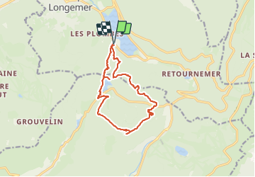
Trail Walking of 12.9 km to be discovered at Grand Est, Vosges, Xonrupt-Longemer. This trail is proposed by oscar1.
Description
Au départ sur 1,100 km montée assez raide et très caillouteux jusqu'à la Roche des Vieux Chevaux. La pente s'étire jusqu'à l'antenne sur 6 kms. Puis une petite montée à nouveau après le lac de Lispach et descente sur quelques centaines de mètres, caillouteux.
Positioning
Country:
France
Region :
Grand Est
Department/Province :
Vosges
Municipality :
Xonrupt-Longemer
Location:
Unknown
Start:(Dec)
Start:(UTM)
347134 ; 5325855 (32U) N.
Comments
Trails nearby
![Trail Walking Gérardmer - gerardmer - la mauselaine . tête grauvelin . Roche boquet . croix claudé . hautes Vannes . la mauselaine - Photo](https://media.geolcdn.com/t/375/260/52e7d67b-2c25-481b-9a23-f7923e7ada1d.jpg&format=jpg&maxdim=2)
![Walking Walking](https://static1.geolcdn.com/sitytour/trail-icons/101.png)
gerardmer - la mauselaine . tête grauvelin . Roche boquet . croix claudé . ha...
Walking
Very easy
(1)
Gérardmer,
Grand Est,
Vosges,
France
![](/images/other/stat-length.png)
11.3 km | 16.2 km-effort
3h 42min
![](https://static1.geolcdn.com/siteimages/upload/files/16400158638029165_repeat_loop_refresh_sync_direction_icon.png)
Yes
![Trail Walking La Bresse - Lac de Lispach et sentier Dielaine - Photo](https://media.geolcdn.com/t/375/260/b54731ea-6209-4cff-b7c0-af5225a4f3ae.jpg&format=jpg&maxdim=2)
![Walking Walking](https://static1.geolcdn.com/sitytour/trail-icons/101.png)
Lac de Lispach et sentier Dielaine
Walking
Medium
(1)
La Bresse,
Grand Est,
Vosges,
France
![](/images/other/stat-length.png)
9.7 km | 14.9 km-effort
2h 30min
![](https://static1.geolcdn.com/siteimages/upload/files/16400158638029165_repeat_loop_refresh_sync_direction_icon.png)
Yes
![Walking Walking](https://static1.geolcdn.com/sitytour/trail-icons/101.png)
Les 5 lacs autour du Hohneck
Walking
Very difficult
(1)
La Bresse,
Grand Est,
Vosges,
France
![](/images/other/stat-length.png)
21 km | 36 km-effort
7h 21min
![](https://static1.geolcdn.com/siteimages/upload/files/16400158638029165_repeat_loop_refresh_sync_direction_icon.png)
Yes
![Trail Walking La Bresse - lac de Lispach - Photo](https://media.geolcdn.com/t/375/260/ext.jpg?maxdim=2&url=https%3A%2F%2Fservices.sitytrail.com%2FGeolivesWS%2FDownloadMedia.ashx%3FTrailID%3D441673%26Media%3D20150705125536.jpg)
![Walking Walking](https://static1.geolcdn.com/sitytour/trail-icons/101.png)
lac de Lispach
Walking
Easy
(1)
La Bresse,
Grand Est,
Vosges,
France
![](/images/other/stat-length.png)
10.4 km | 14.1 km-effort
4h 6min
![](https://static1.geolcdn.com/siteimages/upload/files/16400158638029165_repeat_loop_refresh_sync_direction_icon.png)
Yes
![Trail Walking La Bresse - lac de Lispach - Photo](https://media.geolcdn.com/t/375/260/ext.jpg?maxdim=2&url=https%3A%2F%2Fservices.sitytrail.com%2FGeolivesWS%2FDownloadMedia.ashx%3FTrailID%3D441672%26Media%3D20150705124703.jpg)
![Walking Walking](https://static1.geolcdn.com/sitytour/trail-icons/101.png)
lac de Lispach
Walking
Easy
(3)
La Bresse,
Grand Est,
Vosges,
France
![](/images/other/stat-length.png)
10.4 km | 14.1 km-effort
4h 6min
![](https://static1.geolcdn.com/siteimages/upload/files/16400158638029165_repeat_loop_refresh_sync_direction_icon.png)
Yes
![Trail Walking Ban-sur-Meurthe-Clefcy - La vallée de Belbriette - Ban-sur-Meurthe-Clefcy - Photo](https://media.geolcdn.com/t/375/260/ext.jpg?maxdim=2&url=https%3A%2F%2Fservices.sitytrail.com%2FGeolivesWS%2FDownloadMedia.ashx%3FTrailID%3D172951%26Media%3D14431_5.jpg)
![Walking Walking](https://static1.geolcdn.com/sitytour/trail-icons/101.png)
La vallée de Belbriette - Ban-sur-Meurthe-Clefcy
Walking
Medium
(2)
Ban-sur-Meurthe-Clefcy,
Grand Est,
Vosges,
France
![](/images/other/stat-length.png)
9.8 km | 12.6 km-effort
2h 30min
![](https://static1.geolcdn.com/siteimages/upload/files/16400158638029165_repeat_loop_refresh_sync_direction_icon.png)
Yes
![Trail Walking La Bresse - Du Hohneck au Kastelberg par les Spietzkoepfe et le Sentier des Névées - Photo](https://media.geolcdn.com/t/375/260/ext.jpg?maxdim=2&url=https%3A%2F%2Fservices.sitytrail.com%2FGeolivesWS%2FDownloadMedia.ashx%3FTrailID%3D110319%26Media%3D5746_5.jpg)
![Walking Walking](https://static1.geolcdn.com/sitytour/trail-icons/101.png)
Du Hohneck au Kastelberg par les Spietzkoepfe et le Sentier des Névées
Walking
Very difficult
(3)
La Bresse,
Grand Est,
Vosges,
France
![](/images/other/stat-length.png)
7.6 km | 13.7 km-effort
3h 30min
![](https://static1.geolcdn.com/siteimages/upload/files/16400158638029165_repeat_loop_refresh_sync_direction_icon.png)
Yes
![Trail Walking Xonrupt-Longemer - 23-08-17 Lac Longemer - Lispach - Photo](https://media.geolcdn.com/t/375/260/ext.jpg?maxdim=2&url=https%3A%2F%2Fservices.sitytrail.com%2FGeolivesWS%2FDownloadMedia.ashx%3FTrailID%3D815971%26Media%3Dfix__20170823133945.jpg)
![Walking Walking](https://static1.geolcdn.com/sitytour/trail-icons/101.png)
23-08-17 Lac Longemer - Lispach
Walking
Medium
(1)
Xonrupt-Longemer,
Grand Est,
Vosges,
France
![](/images/other/stat-length.png)
7 km | 12.1 km-effort
2h 13min
![](https://static1.geolcdn.com/siteimages/upload/files/16400158638029165_repeat_loop_refresh_sync_direction_icon.png)
Yes
![Trail Snowshoes Le Valtin - raquettes - Photo](https://media.geolcdn.com/t/375/260/ext.jpg?maxdim=2&url=https%3A%2F%2Fservices.sitytrail.com%2FGeolivesWS%2FDownloadMedia.ashx%3FTrailID%3D531361%26Media%3Dfix__20160228130536.jpg)
![Snowshoes Snowshoes](https://static1.geolcdn.com/sitytour/trail-icons/504.png)
raquettes
Snowshoes
Very easy
(1)
Le Valtin,
Grand Est,
Vosges,
France
![](/images/other/stat-length.png)
6.6 km | 9.4 km-effort
3h 8min
![](https://static1.geolcdn.com/siteimages/upload/files/16400158638029165_repeat_loop_refresh_sync_direction_icon.png)
No