![](/images/other/stat-length.png)
![Trail Walking Marcilly-sur-Vienne - Marcilly-sur-Vienne - PR Vallées et plateaux - 9.6km 140m 2h20 - 2023 08 09 - Photo](https://media.geolcdn.com/t/1900/400/fec5215f-b9be-4875-b761-cec860b4c54b.jpg&format=pjpeg&maxdim=2)
Marcilly-sur-Vienne - PR Vallées et plateaux - 9.6km 140m 2h20 - 2023 08 09
Orcal37
User GUIDE
![Length](/images/other/stat-length.png)
Length
9.6 km
![Max alt](https://static1.geolcdn.com/siteimages/upload/files/1508320355ic_sort_altitude_max_24dp.png)
Max alt
113 m
![Uphill gradient](https://static1.geolcdn.com/siteimages/upload/files/1508320355ic_sort_den_pos_24dp.png)
Uphill gradient
144 m
![Km-Effort](/images/other/stat-length.png)
Km-Effort
11.5 km
![Min alt](https://static1.geolcdn.com/siteimages/upload/files/1508320355ic_sort_altitude_min_24dp.png)
Min alt
34 m
![Downhill gradient](https://static1.geolcdn.com/siteimages/upload/files/1508320355ic_sort_den_neg_24dp.png)
Downhill gradient
144 m
![Boucle](https://static1.geolcdn.com/siteimages/upload/files/16400158638029165_repeat_loop_refresh_sync_direction_icon.png)
Boucle
Yes
Creation date :
2023-08-09 13:25:48.815
Updated on :
2023-08-13 09:48:33.603
![Walking](https://static1.geolcdn.com/sitytour/trail-icons/101.png)
2h20
Difficulty : Medium
![Scan this QR Code to open this trail in the SityTrail application](https://capi.geolives.com/qq0zvz2zws4bq2lad0pu/sitytour/trails/3765161/qr.png?size=200)
FREE GPS app for hiking
About
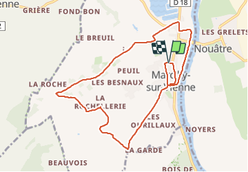
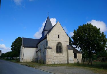
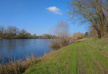
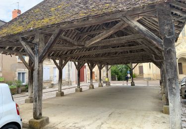
Trail Walking of 9.6 km to be discovered at Centre-Loire Valley, Indre-et-Loire, Marcilly-sur-Vienne. This trail is proposed by Orcal37.
Description
Marcilly-sur-Vienne - PR Vallées et plateaux avec variante du parking de départ - 9.6km 140m 2h20 - 2023 08 09. Niveau moyen à cause du sentier de fin de PR entre le pont et l'église.
Positioning
Country:
France
Region :
Centre-Loire Valley
Department/Province :
Indre-et-Loire
Municipality :
Marcilly-sur-Vienne
Location:
Unknown
Start:(Dec)
Start:(UTM)
313062 ; 5213268 (31T) N.
Comments
Trails nearby
![Trail Walking Port-de-Piles - Port-de-Piles - GR655 GR48 Descartes GRP Touraine Sud - 25.6km 180m 5h30 (45mn) - 2024 04 20 - Photo](https://media.geolcdn.com/t/375/260/d7a7c171-4f05-4aee-8b9b-948ac935ee9a.jpg&format=jpg&maxdim=2)
![Walking Walking](https://static1.geolcdn.com/sitytour/trail-icons/101.png)
Port-de-Piles - GR655 GR48 Descartes GRP Touraine Sud - 25.6km 180m 5h30 (45m...
Walking
Easy
Port-de-Piles,
New Aquitaine,
Vienne,
France
![](/images/other/stat-length.png)
26 km | 29 km-effort
5h 30min
![](https://static1.geolcdn.com/siteimages/upload/files/16400158638029165_repeat_loop_refresh_sync_direction_icon.png)
Yes
![Trail Walking Ports-sur-Vienne - Ports-sur-Vienne - GR48 Pussigny Ponçay - 23.4km 410m 5h15 (50mn) - 2024 04 13 - Photo](https://media.geolcdn.com/t/375/260/8e6643dc-917a-4d6a-9e57-0e2e3f6ec576.jpg&format=jpg&maxdim=2)
![Walking Walking](https://static1.geolcdn.com/sitytour/trail-icons/101.png)
Ports-sur-Vienne - GR48 Pussigny Ponçay - 23.4km 410m 5h15 (50mn) - 2024 04 13
Walking
Medium
Ports-sur-Vienne,
Centre-Loire Valley,
Indre-et-Loire,
France
![](/images/other/stat-length.png)
24 km | 29 km-effort
5h 15min
![](https://static1.geolcdn.com/siteimages/upload/files/16400158638029165_repeat_loop_refresh_sync_direction_icon.png)
Yes
![Trail Walking Pouzay - Pouzay - GR48 Nouâtre Marcilly-sur-Vienne - 17.0km 170m 4h00 (35mn) - 2023 08 09 - Photo](https://media.geolcdn.com/t/375/260/a9bf3336-fbac-45ce-9879-677505dd41c4.jpg&format=jpg&maxdim=2)
![Walking Walking](https://static1.geolcdn.com/sitytour/trail-icons/101.png)
Pouzay - GR48 Nouâtre Marcilly-sur-Vienne - 17.0km 170m 4h00 (35mn) - 2023 08 09
Walking
Easy
Pouzay,
Centre-Loire Valley,
Indre-et-Loire,
France
![](/images/other/stat-length.png)
17 km | 19.2 km-effort
4h 0min
![](https://static1.geolcdn.com/siteimages/upload/files/16400158638029165_repeat_loop_refresh_sync_direction_icon.png)
Yes
![Trail Walking Maillé - Maillé - PR Vallées et plateaux - 15.1km 135m 3h20 (35mn) - 2023 05 06 - Photo](https://media.geolcdn.com/t/375/260/0443a17e-2794-4ae5-8828-42827a64979f.jpg&format=jpg&maxdim=2)
![Walking Walking](https://static1.geolcdn.com/sitytour/trail-icons/101.png)
Maillé - PR Vallées et plateaux - 15.1km 135m 3h20 (35mn) - 2023 05 06
Walking
Very easy
Maillé,
Centre-Loire Valley,
Indre-et-Loire,
France
![](/images/other/stat-length.png)
15.2 km | 17 km-effort
3h 20min
![](https://static1.geolcdn.com/siteimages/upload/files/16400158638029165_repeat_loop_refresh_sync_direction_icon.png)
Yes
![Trail Walking Pouzay - Pouzay - PRs GR48 - 18.6km 160m 3h50 (30mn) - 2021 02 27 - Photo](https://media.geolcdn.com/t/375/260/188c8647-7cd8-4a87-b0d0-847de61dcb03.jpg&format=jpg&maxdim=2)
![Walking Walking](https://static1.geolcdn.com/sitytour/trail-icons/101.png)
Pouzay - PRs GR48 - 18.6km 160m 3h50 (30mn) - 2021 02 27
Walking
Easy
Pouzay,
Centre-Loire Valley,
Indre-et-Loire,
France
![](/images/other/stat-length.png)
18.6 km | 21 km-effort
3h 50min
![](https://static1.geolcdn.com/siteimages/upload/files/16400158638029165_repeat_loop_refresh_sync_direction_icon.png)
Yes
![Trail Walking La Celle-Saint-Avant - Voie de Tours - 9ème étape :La Celle Saint-Avant - Chatellerault - Photo](https://media.geolcdn.com/t/375/260/e3e72082-be17-4d30-909c-d40646efdc1e.jpg&format=jpg&maxdim=2)
![Walking Walking](https://static1.geolcdn.com/sitytour/trail-icons/101.png)
Voie de Tours - 9ème étape :La Celle Saint-Avant - Chatellerault
Walking
Medium
La Celle-Saint-Avant,
Centre-Loire Valley,
Indre-et-Loire,
France
![](/images/other/stat-length.png)
26 km | 28 km-effort
4h 53min
![](https://static1.geolcdn.com/siteimages/upload/files/16400158638029165_repeat_loop_refresh_sync_direction_icon.png)
No
![Trail Running Nouâtre - Martin 10 Km Nouatre - Photo](https://media.geolcdn.com/t/375/260/ext.jpg?maxdim=2&url=https%3A%2F%2Fstatic1.geolcdn.com%2Fsiteimages%2Fupload%2Ffiles%2F1524743154running.jpg)
![Running Running](https://static1.geolcdn.com/sitytour/trail-icons/103.png)
Martin 10 Km Nouatre
Running
Very easy
Nouâtre,
Centre-Loire Valley,
Indre-et-Loire,
France
![](/images/other/stat-length.png)
9 km | 9.9 km-effort
Unknown
![](https://static1.geolcdn.com/siteimages/upload/files/16400158638029165_repeat_loop_refresh_sync_direction_icon.png)
Yes
![Trail Walking Pouzay - 2023-08-16 grosse journée - Photo](https://media.geolcdn.com/t/375/260/ext.jpg?maxdim=2&url=https%3A%2F%2Fstatic1.geolcdn.com%2Fsiteimages%2Fupload%2Ffiles%2F1553511878bg_sport_marche.png)
![Walking Walking](https://static1.geolcdn.com/sitytour/trail-icons/101.png)
2023-08-16 grosse journée
Walking
Very difficult
Pouzay,
Centre-Loire Valley,
Indre-et-Loire,
France
![](/images/other/stat-length.png)
18.3 km | 22 km-effort
6h 51min
![](https://static1.geolcdn.com/siteimages/upload/files/16400158638029165_repeat_loop_refresh_sync_direction_icon.png)
No
![Trail Bicycle tourism Marcilly-sur-Vienne - E13 - La Loire à vélo - Marcilly sur Vienne > Dissay - Photo](https://media.geolcdn.com/t/375/260/ext.jpg?maxdim=2&url=https%3A%2F%2Fstatic1.geolcdn.com%2Fsiteimages%2Fupload%2Ffiles%2F1524743154velo.jpg)
![Bicycle tourism Bicycle tourism](https://static1.geolcdn.com/sitytour/trail-icons/204.png)
E13 - La Loire à vélo - Marcilly sur Vienne > Dissay
Bicycle tourism
Medium
Marcilly-sur-Vienne,
Centre-Loire Valley,
Indre-et-Loire,
France
![](/images/other/stat-length.png)
54 km | 60 km-effort
3h 19min
![](https://static1.geolcdn.com/siteimages/upload/files/16400158638029165_repeat_loop_refresh_sync_direction_icon.png)
No