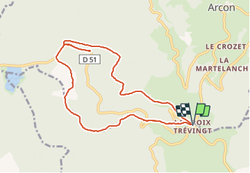
![](/images/other/stat-length.png)
![Trail Walking Cherier - rocher de rochefort depuis la croix Trévingt - Photo](https://media.geolcdn.com/t/1900/400/dcc1659c-efdc-4c94-9e85-a848a823e0bd.jpg&format=pjpeg&maxdim=2)
rocher de rochefort depuis la croix Trévingt
famillerudent
User
![Length](/images/other/stat-length.png)
![Max alt](https://static1.geolcdn.com/siteimages/upload/files/1508320355ic_sort_altitude_max_24dp.png)
![Uphill gradient](https://static1.geolcdn.com/siteimages/upload/files/1508320355ic_sort_den_pos_24dp.png)
![Km-Effort](/images/other/stat-length.png)
![Min alt](https://static1.geolcdn.com/siteimages/upload/files/1508320355ic_sort_altitude_min_24dp.png)
![Downhill gradient](https://static1.geolcdn.com/siteimages/upload/files/1508320355ic_sort_den_neg_24dp.png)
![Boucle](https://static1.geolcdn.com/siteimages/upload/files/16400158638029165_repeat_loop_refresh_sync_direction_icon.png)
![Walking](https://static1.geolcdn.com/sitytour/trail-icons/101.png)
3h10
Difficulty : Easy
![Scan this QR Code to open this trail in the SityTrail application](https://capi.geolives.com/qq0zvz2zws4bq2lad0pu/sitytour/trails/3764726/qr.png?size=200)
FREE GPS app for hiking
About
Trail Walking of 9.3 km to be discovered at Auvergne-Rhône-Alpes, Loire, Cherier. This trail is proposed by famillerudent.
Description
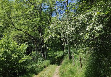
cette randonnée est une variante de la rando "le bois greffier " de la balade bleu 1 de roannais agglo.elle passe par le pic de rochefort avec une superbe vue et empreinte pas mal de chemins en forêt à 900 metres d4altitude en moyenne donc trés agréable a faire par temps chaud
Positioning
Comments
Trails nearby
![Trail Walking - Randonnée sur les plateaux au dessus du village de Moulins -Chérier - Photo](https://media.geolcdn.com/t/375/260/328a50ea-b5e1-4410-88c7-07bd0b3b435c.jpg&format=jpg&maxdim=2)
![Walking Walking](https://static1.geolcdn.com/sitytour/trail-icons/101.png)
Walking
![](/images/other/stat-length.png)
![](https://static1.geolcdn.com/siteimages/upload/files/16400158638029165_repeat_loop_refresh_sync_direction_icon.png)
![Trail Walking Arcon - Arcon: Roche Corbière-Quatre Murs - Photo](https://media.geolcdn.com/t/375/260/f084a593-c8ab-4485-bad9-4355d9e9f1a8.jpg&format=jpg&maxdim=2)
![Walking Walking](https://static1.geolcdn.com/sitytour/trail-icons/101.png)
Walking
![](/images/other/stat-length.png)
![](https://static1.geolcdn.com/siteimages/upload/files/16400158638029165_repeat_loop_refresh_sync_direction_icon.png)
![Trail Walking Cherier - rando à Moulin Charier - Photo](https://media.geolcdn.com/t/375/260/3886ddf7-94b0-4692-af5c-3d0753f12223.jpg&format=jpg&maxdim=2)
![Walking Walking](https://static1.geolcdn.com/sitytour/trail-icons/101.png)
Walking
![](/images/other/stat-length.png)
![](https://static1.geolcdn.com/siteimages/upload/files/16400158638029165_repeat_loop_refresh_sync_direction_icon.png)
![Trail Walking Cherier - Les Moulins Chérier : entre Les Faux et Montloup - Photo](https://media.geolcdn.com/t/375/260/35e95e0f-9bf0-4632-a277-b5de924d69b4.jpg&format=jpg&maxdim=2)
![Walking Walking](https://static1.geolcdn.com/sitytour/trail-icons/101.png)
Walking
![](/images/other/stat-length.png)
![](https://static1.geolcdn.com/siteimages/upload/files/16400158638029165_repeat_loop_refresh_sync_direction_icon.png)
![Trail On foot Cherier - Les Moulins Chérier - boucles autour du vieux bourg - Photo](https://media.geolcdn.com/t/375/260/02a5a11d-56eb-4a94-af63-ae9a9466184f.jpg&format=jpg&maxdim=2)
![On foot On foot](https://static1.geolcdn.com/sitytour/trail-icons/100.png)
On foot
![](/images/other/stat-length.png)
![](https://static1.geolcdn.com/siteimages/upload/files/16400158638029165_repeat_loop_refresh_sync_direction_icon.png)
![Trail Walking Saint-André-d'Apchon - St-André-d'Apchon-Rocher de Bellevue - Photo](https://media.geolcdn.com/t/375/260/8e975bfa-15cb-4d0f-9f11-d5beb6ba5a25.jpg&format=jpg&maxdim=2)
![Walking Walking](https://static1.geolcdn.com/sitytour/trail-icons/101.png)
Walking
![](/images/other/stat-length.png)
![](https://static1.geolcdn.com/siteimages/upload/files/16400158638029165_repeat_loop_refresh_sync_direction_icon.png)
![Walking Walking](https://static1.geolcdn.com/sitytour/trail-icons/101.png)
Walking
![](/images/other/stat-length.png)
![](https://static1.geolcdn.com/siteimages/upload/files/16400158638029165_repeat_loop_refresh_sync_direction_icon.png)
![Trail Mountain bike - VTT sportif à Moulins-Chérier - Photo](https://media.geolcdn.com/t/375/260/ext.jpg?maxdim=2&url=https%3A%2F%2Fservices.sitytrail.com%2FGeolivesWS%2FDownloadMedia.ashx%3FTrailID%3D105815%26Media%3D9743_6.jpg)
![Mountain bike Mountain bike](https://static1.geolcdn.com/sitytour/trail-icons/202.png)
Mountain bike
![](/images/other/stat-length.png)
![](https://static1.geolcdn.com/siteimages/upload/files/16400158638029165_repeat_loop_refresh_sync_direction_icon.png)
![Trail Walking - Marche des Pentes & Côtes à Moulins Cherier - Photo](https://media.geolcdn.com/t/375/260/ext.jpg?maxdim=2&url=https%3A%2F%2Fservices.sitytrail.com%2FGeolivesWS%2FDownloadMedia.ashx%3FTrailID%3D105063%26Media%3D8644_6.jpg)
![Walking Walking](https://static1.geolcdn.com/sitytour/trail-icons/101.png)
Walking
![](/images/other/stat-length.png)
![](https://static1.geolcdn.com/siteimages/upload/files/16400158638029165_repeat_loop_refresh_sync_direction_icon.png)