Trail Walking Erro - ARGINTZU - KINTOA BORDA DEPUIS URKIAGA - Photo

ARGINTZU - KINTOA BORDA DEPUIS URKIAGA

 Ipoh64
Ipoh64

User

© OpenStreetMap contributors
Length
Length
12.9 km
Max alt
Max alt
1220 m
Uphill gradient
Uphill gradient
580 m
Km-Effort
Km-Effort  
21 km
Min alt
Min alt
917 m
Downhill gradient
Downhill gradient
579 m
Boucle
Boucle
Yes
Creation date :
2023-08-08 07:41:42.777
Updated on :
2023-08-08 17:18:16.516

(0 Reviews)

Walking
Walking
6h39
Difficulty : Easy

Scan this QR Code to open this trail in the SityTrail application

FREE GPS app for hiking

Logo SityTrail SityTrail

IGN / Geographical institutes

Download SityTrail from the App Store Download SityTrail from Google Play

Logo SityTrail SityTrail World

The world is yours!

Download SityTrail from the App Store Download SityTrail from Google Play Download SityTrail on Huawei AppGallery

About

Trail Walking of 12.9 km to be discovered at Navarre, Unknown, Erro. This trail is proposed by Ipoh64.

Description

Pas de difficulté.  Beaux passages en sous bois.

Elevation profile

Photos

Positioning

Country:
Spain
Region :
Navarre
Department/Province :
Unknown
Municipality :
Erro
Location:
Unknown
Start:(UTM)
624626 ; 4765949 (30T) N.

Trails nearby

Trail On foot Erro - Zilbeti - Sorogain - Photo
On foot
GUIDE+

On foot

Easy
Erro, Navarre, Unknown, Spain
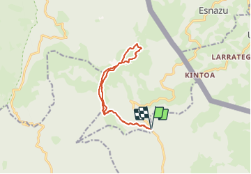
8.1 km | 12.9 km-effort
2h 56min
No
Trail Walking Urepel - urepel - Photo
Walking
marchev

Walking

Medium
Urepel, New Aquitaine, Pyrénées-Atlantiques, France
14.4 km | 22 km-effort
6h 18min
Yes
Trail Walking Urepel - Les aldudes urepel - Photo
Walking
chrifor

Walking

Difficult
Urepel, New Aquitaine, Pyrénées-Atlantiques, France
14.6 km | 22 km-effort
6h 8min
Yes
Trail Mountain bike Urepel - Le Sentier des Contrebandiers en VTT - De Urepel à St Etienne de Baïgorry - Photo
Mountain bike
tracegps

Mountain bike

Difficult
Urepel, New Aquitaine, Pyrénées-Atlantiques, France
34 km | 56 km-effort
6h 0min
No
Trail Equestrian Urepel - Sentier des Contrebandiers - de Urepel au col d'Elhorrieta au Pays Basque - Photo
Equestrian
tracegps

Equestrian

Difficult
Urepel, New Aquitaine, Pyrénées-Atlantiques, France
24 km | 42 km-effort
5h 0min
No
Trail Running Urepel - Euskal Raid 2005 - 2 - Photo
Running
tracegps

Running

Very difficult
Urepel, New Aquitaine, Pyrénées-Atlantiques, France
38 km | 68 km-effort
8h 0min
No
Trail Mountain bike Erro - 20210904081701_Biking - Photo
Mountain bike
patxargi

Mountain bike

Difficult
Erro, Navarre, Unknown, Spain
27 km | 38 km-effort
2h 38min
No
Trail Horseback riding Urepel - Xxx - Elizondo - Photo
Horseback riding
alfreson

Horseback riding

Medium
Urepel, New Aquitaine, Pyrénées-Atlantiques, France
21 km | 29 km-effort
5h 0min
No
Trail Walking Baztan - etapa4 - Photo
Walking
phelan

Walking

Very difficult
Baztan, Navarre, Unknown, Spain
17.3 km | 28 km-effort
5h 40min
No


Close
My subscriptions