Trail Walking Puy-Sanières - sentier de Vanook CERS - Photo
 damlou
damlou

User

© OpenStreetMap contributors
Length
Length
6.7 km
Max alt
Max alt
1383 m
Uphill gradient
Uphill gradient
222 m
Km-Effort
Km-Effort  
9.7 km
Min alt
Min alt
1212 m
Downhill gradient
Downhill gradient
222 m
Boucle
Boucle
Yes
Creation date :
2023-08-08 07:57:05.647
Updated on :
2023-08-08 13:27:49.141

(0 Reviews)

Walking
Walking
2h28
Difficulty : Easy

Scan this QR Code to open this trail in the SityTrail application

FREE GPS app for hiking

Logo SityTrail SityTrail

IGN / Geographical institutes

Download SityTrail from the App Store Download SityTrail from Google Play

Logo SityTrail SityTrail World

The world is yours!

Download SityTrail from the App Store Download SityTrail from Google Play Download SityTrail on Huawei AppGallery

About

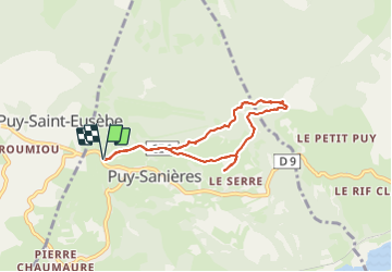
Trail Walking of 6.7 km to be discovered at Provence-Alpes-Côte d'Azur, Hautes-Alpes, Puy-Sanières. This trail is proposed by damlou.

Description

première partie boisee
Deuxième partie à découvert

Elevation profile

Positioning

Country:
France
Region :
Provence-Alpes-Côte d'Azur
Department/Province :
Hautes-Alpes
Municipality :
Puy-Sanières
Location:
Unknown
Start:(UTM)
295534 ; 4937229 (32T) N.

Comments

Please log in to post a review or rate the element


p55 bouquin Guillaine cers groupe cool


Trails nearby

Trail Walking Réallon - AIguilles de Chabrieres au départ de la Station de ski Reallon - Photo
Walking
Maca8284

Walking

Very difficult
(1)
Réallon, Provence-Alpes-Côte d'Azur, Hautes-Alpes, France
14 km | 25 km-effort
6h 0min
Yes
Trail Walking Embrun - Lac de l'Hivernet - Photo
Walking
gildascb

Walking

Easy
(1)
Embrun, Provence-Alpes-Côte d'Azur, Hautes-Alpes, France
10.6 km | 21 km-effort
3h 55min
Yes
Trail Walking Réallon - le fort de Réallon - Photo
Walking
gildascb

Walking

Very easy
(1)
Réallon, Provence-Alpes-Côte d'Azur, Hautes-Alpes, France
8 km | 11.8 km-effort
2h 11min
Yes
Trail Walking Embrun - Mont Guillaume-Col de Chanté Perdrix-Lac de l'Hivernet(07-09-16) - Photo
Walking
Dervalmarc

Walking

Difficult
(2)
Embrun, Provence-Alpes-Côte d'Azur, Hautes-Alpes, France
15.4 km | 31 km-effort
7h 4min
Yes
Trail Walking Puy-Saint-Eusèbe - canal de reyssas jusqu'aux Touisses / retour par le GR Serre-Ponçon via ravin de la pisse  - Photo
Walking
GUIDE
stef789

Walking

Medium
Puy-Saint-Eusèbe, Provence-Alpes-Côte d'Azur, Hautes-Alpes, France
9.7 km | 15.4 km-effort
4h 51min
Yes
Trail Walking Embrun - Mont Guillaume - Col de Trempa-Latz - 2671 - 10/09/23 - Photo
Walking
GUIDE
R@ph

Walking

Very difficult
Embrun, Provence-Alpes-Côte d'Azur, Hautes-Alpes, France
13.6 km | 28 km-effort
6h 20min
Yes
Trail Walking Embrun - Mont Guillaume - Photo
Walking
GUIDE
Marco05

Walking

Difficult
Embrun, Provence-Alpes-Côte d'Azur, Hautes-Alpes, France
12.6 km | 26 km-effort
5h 55min
Yes
Trail Snowshoes Réallon - Raquettes Réallon  - Photo
Snowshoes
GUIDE
David25400

Snowshoes

Easy
Réallon, Provence-Alpes-Côte d'Azur, Hautes-Alpes, France
6.5 km | 14.3 km-effort
3h 27min
Yes
Trail Walking Embrun - Mt Guillaume - Lac de l'Hivernet - Photo
Walking
GUIDE
David25400

Walking

Difficult
Embrun, Provence-Alpes-Côte d'Azur, Hautes-Alpes, France
12.7 km | 28 km-effort
4h 8min
Yes


Close
My subscriptions