Lamaziere Basse SityTrail > Trails > Outdoor > France > New Aquitaine > Corrèze > Lamazière-Basse SityTrail > Trails > Outdoor > France > New Aquitaine > Corrèze > Lamazière-Basse Lamaziere Basse hl44lv User 3D © OpenStreetMap contributors Length 9.9 km Max alt 628 m Uphill gradient 214 m Km-Effort 12.8 km Min alt 533 m Downhill gradient 213 m Boucle Yes Creation date : 2023-08-07 08:54:04.0 Updated on : 2023-08-07 12:05:19.002 (0 Reviews) FREE GPS app for hiking SityTrail IGN / Geographical institutes SityTrail World The world is yours! About 
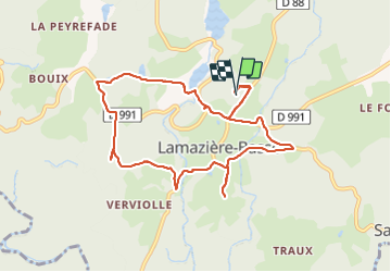
Trail of 9.9 km to be discovered at New Aquitaine, Corrèze, Lamazière-Basse. This trail is proposed by hl44lv. Legends | More details (PDF) Elevation profile Legends > 15% 15% - 10% 10% - 5% flat 5% - 10% 10% - 15% 15% - 30% > 30% Photos Positioning Country: France Region : New Aquitaine Department/Province : Corrèze Municipality : Lamazière-Basse Location: Unknown Start:(Dec) 45.37784 / 2.173475 Start:(UTM) 435287 ; 5025257 (31T) N. Comments Please log in to post a review or rate the element Trails nearby tracegps Circuit des étangs - Lamazière Basse - Pays de Haute Corrèze Walking Medium (1) Lamazière-Basse, New Aquitaine, Corrèze, France 5.5 km | 6.8 km-effort 1h 30min Yes tracegps La Luzège aux eaux vives - Darnets - Pays d'Egletons Walking Medium (1) Darnets, New Aquitaine, Corrèze, France 4.1 km | 6.5 km-effort 1h 40min Yes viam19 rando lamas Walking Very easy Lamazière-Basse, New Aquitaine, Corrèze, France 12.4 km | 15.3 km-effort 4h 10min Yes fanclem Pont Bouyges-Le Chatelet On foot Easy Moustier-Ventadour, New Aquitaine, Corrèze, France 12.3 km | 17.7 km-effort 4h 1min Yes fanclem gane Walking Medium Lamazière-Basse, New Aquitaine, Corrèze, France 8 km | 12 km-effort 2h 9min No