![](/images/other/stat-length.png)
![Trail Walking Saint-Cirgues-la-Loutre - le Gourdaloup - Photo](https://media.geolcdn.com/t/1900/400/32c17a79-c1ba-4c25-a7e6-d0d33eb021a6.jpg&format=pjpeg&maxdim=2)
le Gourdaloup
laurentbernardbrunel
User
![Length](/images/other/stat-length.png)
Length
15.1 km
![Max alt](https://static1.geolcdn.com/siteimages/upload/files/1508320355ic_sort_altitude_max_24dp.png)
Max alt
533 m
![Uphill gradient](https://static1.geolcdn.com/siteimages/upload/files/1508320355ic_sort_den_pos_24dp.png)
Uphill gradient
458 m
![Km-Effort](/images/other/stat-length.png)
Km-Effort
21 km
![Min alt](https://static1.geolcdn.com/siteimages/upload/files/1508320355ic_sort_altitude_min_24dp.png)
Min alt
282 m
![Downhill gradient](https://static1.geolcdn.com/siteimages/upload/files/1508320355ic_sort_den_neg_24dp.png)
Downhill gradient
460 m
![Boucle](https://static1.geolcdn.com/siteimages/upload/files/16400158638029165_repeat_loop_refresh_sync_direction_icon.png)
Boucle
Yes
Creation date :
2023-08-06 09:53:32.0
Updated on :
2023-08-06 19:50:21.769
![Walking](https://static1.geolcdn.com/sitytour/trail-icons/101.png)
3h58
Difficulty : Difficult
![Scan this QR Code to open this trail in the SityTrail application](https://capi.geolives.com/qq0zvz2zws4bq2lad0pu/sitytour/trails/3761077/qr.png?size=200)
FREE GPS app for hiking
About
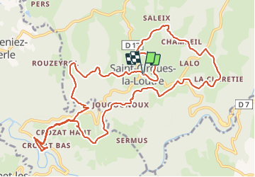
Trail Walking of 15.1 km to be discovered at New Aquitaine, Corrèze, Saint-Cirgues-la-Loutre. This trail is proposed by laurentbernardbrunel.
Description
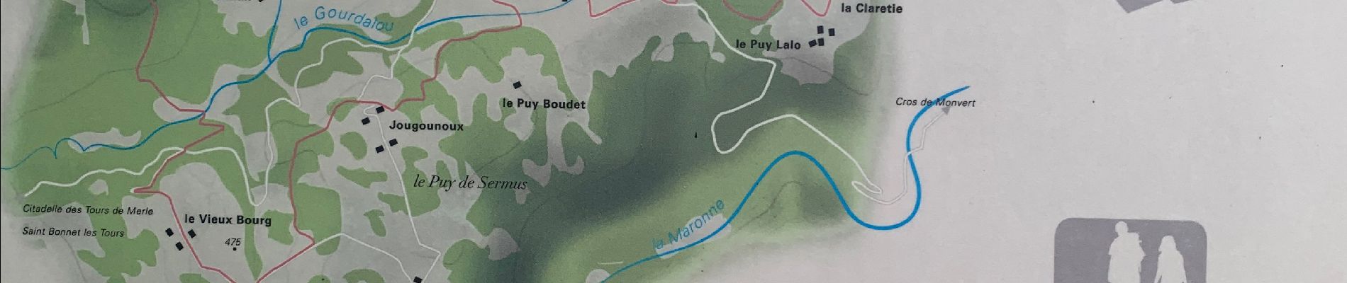
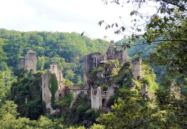
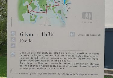
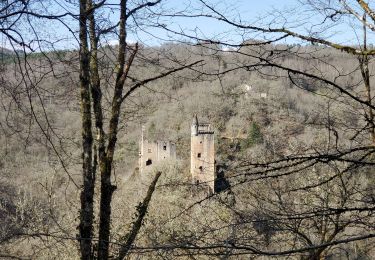
Inspiré d'une randonnée affichée près de l'église de St Cirgues-la-Loutre mais avec une variante pour accéder aux Tours de Merle.
Une boucle dans le coeur de la Xaintrie.
Positioning
Country:
France
Region :
New Aquitaine
Department/Province :
Corrèze
Municipality :
Saint-Cirgues-la-Loutre
Location:
Unknown
Start:(Dec)
Start:(UTM)
429089 ; 4992086 (31T) N.
Comments
Trails nearby
![Trail Walking Saint-Cirgues-la-Loutre - Le Gourdaloup 6 km - Saint Cirgues la Loutre - Pays de la Vallée de la Dordogne Corrézienne - Photo](https://media.geolcdn.com/t/375/260/ext.jpg?maxdim=2&url=https%3A%2F%2Fservices.sitytrail.com%2FGeolivesWS%2FDownloadMedia.ashx%3FTrailID%3D112330%26Media%3D10360_1.jpg)
![Walking Walking](https://static1.geolcdn.com/sitytour/trail-icons/101.png)
Le Gourdaloup 6 km - Saint Cirgues la Loutre - Pays de la Vallée de la Dordog...
Walking
Easy
(1)
Saint-Cirgues-la-Loutre,
New Aquitaine,
Corrèze,
France
![](/images/other/stat-length.png)
6.6 km | 9.1 km-effort
1h 30min
![](https://static1.geolcdn.com/siteimages/upload/files/16400158638029165_repeat_loop_refresh_sync_direction_icon.png)
Yes
![Trail Walking Saint-Cirgues-la-Loutre - Les Tours de Merlé - Saint Cirgues la Loutre - Photo](https://media.geolcdn.com/t/375/260/ext.jpg?maxdim=2&url=https%3A%2F%2Fservices.sitytrail.com%2FGeolivesWS%2FDownloadMedia.ashx%3FTrailID%3D106306%26Media%3D10691_1.jpg)
![Walking Walking](https://static1.geolcdn.com/sitytour/trail-icons/101.png)
Les Tours de Merlé - Saint Cirgues la Loutre
Walking
Difficult
(3)
Saint-Cirgues-la-Loutre,
New Aquitaine,
Corrèze,
France
![](/images/other/stat-length.png)
14.2 km | 20 km-effort
4h 0min
![](https://static1.geolcdn.com/siteimages/upload/files/16400158638029165_repeat_loop_refresh_sync_direction_icon.png)
Yes
![Trail Walking Goulles - Fred BC GOULLES - Photo](https://media.geolcdn.com/t/375/260/e8141b16-10db-4c81-af02-a30b2efafbbf.jpg&format=jpg&maxdim=2)
![Walking Walking](https://static1.geolcdn.com/sitytour/trail-icons/101.png)
Fred BC GOULLES
Walking
Medium
Goulles,
New Aquitaine,
Corrèze,
France
![](/images/other/stat-length.png)
8.3 km | 11.4 km-effort
2h 49min
![](https://static1.geolcdn.com/siteimages/upload/files/16400158638029165_repeat_loop_refresh_sync_direction_icon.png)
Yes
![Trail Walking Saint-Julien-aux-Bois - Croix de Sagiran - Photo](https://media.geolcdn.com/t/375/260/1a371f0d-5b0a-4f26-a8f1-d42b6e1251d5.jpg&format=jpg&maxdim=2)
![Walking Walking](https://static1.geolcdn.com/sitytour/trail-icons/101.png)
Croix de Sagiran
Walking
Easy
Saint-Julien-aux-Bois,
New Aquitaine,
Corrèze,
France
![](/images/other/stat-length.png)
6 km | 7.3 km-effort
2h 12min
![](https://static1.geolcdn.com/siteimages/upload/files/16400158638029165_repeat_loop_refresh_sync_direction_icon.png)
Yes
![Trail Walking Goulles - Les tours Carbonnieres - Photo](https://media.geolcdn.com/t/375/260/90a7e5fb-b218-42bd-a403-ae58cfbb4d41.jpg&format=jpg&maxdim=2)
![Walking Walking](https://static1.geolcdn.com/sitytour/trail-icons/101.png)
Les tours Carbonnieres
Walking
Difficult
Goulles,
New Aquitaine,
Corrèze,
France
![](/images/other/stat-length.png)
11.4 km | 16 km-effort
4h 20min
![](https://static1.geolcdn.com/siteimages/upload/files/16400158638029165_repeat_loop_refresh_sync_direction_icon.png)
Yes
![Trail Walking Saint-Geniez-ô-Merle - 20210615 Tours de Merle - Photo](https://media.geolcdn.com/t/375/260/6024fabf-7fcc-4d15-853b-ddcf0aa5120e.jpg&format=jpg&maxdim=2)
![Walking Walking](https://static1.geolcdn.com/sitytour/trail-icons/101.png)
20210615 Tours de Merle
Walking
Medium
Saint-Geniez-ô-Merle,
New Aquitaine,
Corrèze,
France
![](/images/other/stat-length.png)
4.9 km | 7.4 km-effort
4h 28min
![](https://static1.geolcdn.com/siteimages/upload/files/16400158638029165_repeat_loop_refresh_sync_direction_icon.png)
Yes
![Trail Walking Saint-Privat - Malesse - tours de Merle - Photo](https://media.geolcdn.com/t/375/260/cf29b99a-6a16-4068-860b-c6da043e231f.jpg&format=jpg&maxdim=2)
![Walking Walking](https://static1.geolcdn.com/sitytour/trail-icons/101.png)
Malesse - tours de Merle
Walking
Medium
Saint-Privat,
New Aquitaine,
Corrèze,
France
![](/images/other/stat-length.png)
12.8 km | 16.8 km-effort
3h 42min
![](https://static1.geolcdn.com/siteimages/upload/files/16400158638029165_repeat_loop_refresh_sync_direction_icon.png)
No
![Trail Walking Saint-Geniez-ô-Merle - Les tours de Merle - Photo](https://media.geolcdn.com/t/375/260/ext.jpg?maxdim=2&url=https%3A%2F%2Fservices.sitytrail.com%2FGeolivesWS%2FDownloadMedia.ashx%3FTrailID%3D705307%26Media%3D9368312f-2f0c-4c6e-b94a-95b4492775b0.JPG)
![Walking Walking](https://static1.geolcdn.com/sitytour/trail-icons/101.png)
Les tours de Merle
Walking
Difficult
(2)
Saint-Geniez-ô-Merle,
New Aquitaine,
Corrèze,
France
![](/images/other/stat-length.png)
11.2 km | 16.9 km-effort
3h 42min
![](https://static1.geolcdn.com/siteimages/upload/files/16400158638029165_repeat_loop_refresh_sync_direction_icon.png)
Yes
![Trail Mountain bike Saint-Cirgues-la-Loutre - Le Gourdaloup 12 km - Saint Cirgues la Loutre - Pays de la Vallée de la Dordogne Corrézienne - Photo](https://media.geolcdn.com/t/375/260/ext.jpg?maxdim=2&url=https%3A%2F%2Fservices.sitytrail.com%2FGeolivesWS%2FDownloadMedia.ashx%3FTrailID%3D112299%26Media%3D10305_1.jpg)
![Mountain bike Mountain bike](https://static1.geolcdn.com/sitytour/trail-icons/202.png)
Le Gourdaloup 12 km - Saint Cirgues la Loutre - Pays de la Vallée de la Dordo...
Mountain bike
Medium
Saint-Cirgues-la-Loutre,
New Aquitaine,
Corrèze,
France
![](/images/other/stat-length.png)
11.9 km | 16.1 km-effort
1h 0min
![](https://static1.geolcdn.com/siteimages/upload/files/16400158638029165_repeat_loop_refresh_sync_direction_icon.png)
Yes