Seguzzo SityTrail > Trails > Outdoor > Italy > Emilia-Romagna > Piacenza > Alta Val Tidone SityTrail > Trails > Outdoor > Italy > Emilia-Romagna > Piacenza > Alta Val Tidone Seguzzo ajpbm User 3D © OpenStreetMap contributors Length 12.4 km Max alt 394 m Uphill gradient 283 m Km-Effort 16.2 km Min alt 163 m Downhill gradient 283 m Boucle Yes Creation date : 2023-08-05 16:43:54.528 Updated on : 2023-08-05 20:07:20.224 (0 Reviews) Mountain bike 1h34 Difficulty : Very easy FREE GPS app for hiking SityTrail IGN / Geographical institutes SityTrail World The world is yours! About Trail Mountain bike of 12.4 km to be discovered at Emilia-Romagna, Piacenza, Alta Val Tidone. This trail is proposed by ajpbm. Legends | More details (PDF) Elevation profile Legends > 15% 15% - 10% 10% - 5% flat 5% - 10% 10% - 15% 15% - 30% > 30% Positioning Country: Italy Region : Emilia-Romagna Department/Province : Piacenza Municipality : Alta Val Tidone Location: Unknown Start:(Dec) 44.9676921 / 9.3892882 Start:(UTM) 530699 ; 4979435 (32T) N. Comments Please log in to post a review or rate the element Trails nearby GUIDE+ IT-221 On foot Easy Alta Val Tidone, Emilia-Romagna, Piacenza, Italy 
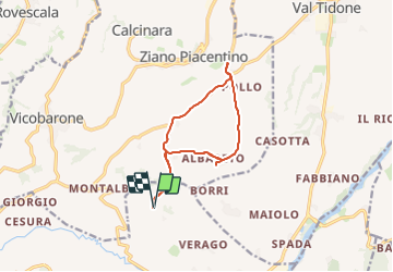
10.2 km | 12.3 km-effort 2h 47min No