![](/images/other/stat-length.png)
![Trail Walking Nozeroy - Jura J1 G3 - Le Moulin de Saut - L'Usine Elect - La source de l'Ain 7 km 220 m - Photo](https://media.geolcdn.com/t/1900/400/ext.pjpeg?maxdim=2&url=https%3A%2F%2Fstatic1.geolcdn.com%2Fsiteimages%2Fupload%2Ffiles%2F1553511878bg_sport_marche.png)
Jura J1 G3 - Le Moulin de Saut - L'Usine Elect - La source de l'Ain 7 km 220 m
Les 1000 pattes
Club randonnées SERVON
![Length](/images/other/stat-length.png)
Length
7 km
![Max alt](https://static1.geolcdn.com/siteimages/upload/files/1508320355ic_sort_altitude_max_24dp.png)
Max alt
753 m
![Uphill gradient](https://static1.geolcdn.com/siteimages/upload/files/1508320355ic_sort_den_pos_24dp.png)
Uphill gradient
225 m
![Km-Effort](/images/other/stat-length.png)
Km-Effort
10 km
![Min alt](https://static1.geolcdn.com/siteimages/upload/files/1508320355ic_sort_altitude_min_24dp.png)
Min alt
671 m
![Downhill gradient](https://static1.geolcdn.com/siteimages/upload/files/1508320355ic_sort_den_neg_24dp.png)
Downhill gradient
215 m
![Boucle](https://static1.geolcdn.com/siteimages/upload/files/16400158638029165_repeat_loop_refresh_sync_direction_icon.png)
Boucle
Yes
Creation date :
2023-08-02 15:50:38.485
Updated on :
2024-02-23 15:55:26.284
![Walking](https://static1.geolcdn.com/sitytour/trail-icons/101.png)
2h16
Difficulty : Medium
![Scan this QR Code to open this trail in the SityTrail application](https://capi.geolives.com/qq0zvz2zws4bq2lad0pu/sitytour/trails/3756385/qr.png?size=200)
FREE GPS app for hiking
About
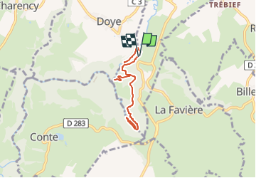
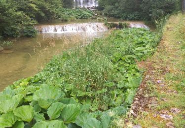
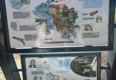
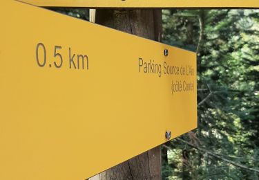
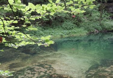
Trail Walking of 7 km to be discovered at Bourgogne-Franche-Comté, Jura, Nozeroy. This trail is proposed by Les 1000 pattes.
Description
Parking Waze :
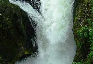
"Parking Cascade Moulin du Saut - Doye 39250"
Trajet aller 10 km 10 min
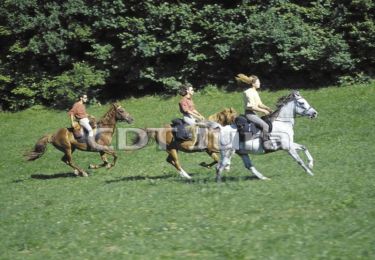
Positioning
Country:
France
Region :
Bourgogne-Franche-Comté
Department/Province :
Jura
Municipality :
Nozeroy
Location:
Unknown
Start:(Dec)
Start:(UTM)
272753 ; 5182963 (32T) N.
Comments
Trails nearby
![Trail Equestrian Longcochon - Haut Jura - Longcochon - Cerniébaud - Photo](https://media.geolcdn.com/t/375/260/ext.jpg?maxdim=2&url=https%3A%2F%2Fservices.sitytrail.com%2FGeolivesWS%2FDownloadMedia.ashx%3FTrailID%3D109529%26Media%3D4106_1.jpg)
![Equestrian Equestrian](https://static1.geolcdn.com/sitytour/trail-icons/300.png)
Haut Jura - Longcochon - Cerniébaud
Equestrian
Difficult
(1)
Longcochon,
Bourgogne-Franche-Comté,
Jura,
France
![](/images/other/stat-length.png)
22 km | 29 km-effort
3h 0min
![](https://static1.geolcdn.com/siteimages/upload/files/16400158638029165_repeat_loop_refresh_sync_direction_icon.png)
No
![Trail Walking Nozeroy - Source de l'Ain - Photo](https://media.geolcdn.com/t/375/260/ext.jpg?maxdim=2&url=https%3A%2F%2Fservices.sitytrail.com%2FGeolivesWS%2FDownloadMedia.ashx%3FTrailID%3D108772%26Media%3D1914_2.jpg)
![Walking Walking](https://static1.geolcdn.com/sitytour/trail-icons/101.png)
Source de l'Ain
Walking
Medium
(2)
Nozeroy,
Bourgogne-Franche-Comté,
Jura,
France
![](/images/other/stat-length.png)
13.4 km | 18.9 km-effort
3h 30min
![](https://static1.geolcdn.com/siteimages/upload/files/16400158638029165_repeat_loop_refresh_sync_direction_icon.png)
Yes
![Trail Walking Bourg-de-Sirod - Perte de l'Ain 15.7.24 - Photo](https://media.geolcdn.com/t/375/260/aaa758b8-4f1b-4118-8f05-a4dd877d998a.jpg&format=jpg&maxdim=2)
![Walking Walking](https://static1.geolcdn.com/sitytour/trail-icons/101.png)
Perte de l'Ain 15.7.24
Walking
Easy
Bourg-de-Sirod,
Bourgogne-Franche-Comté,
Jura,
France
![](/images/other/stat-length.png)
3.3 km | 4.9 km-effort
1h 15min
![](https://static1.geolcdn.com/siteimages/upload/files/16400158638029165_repeat_loop_refresh_sync_direction_icon.png)
Yes
![Trail Walking Nozeroy - Source de l'Ain 15.7.24 - Photo](https://media.geolcdn.com/t/375/260/11e5e982-6bdf-4a43-91a6-2d537d4530ca.jpg&format=jpg&maxdim=2)
![Walking Walking](https://static1.geolcdn.com/sitytour/trail-icons/101.png)
Source de l'Ain 15.7.24
Walking
Easy
Nozeroy,
Bourgogne-Franche-Comté,
Jura,
France
![](/images/other/stat-length.png)
6.1 km | 8.5 km-effort
2h 0min
![](https://static1.geolcdn.com/siteimages/upload/files/16400158638029165_repeat_loop_refresh_sync_direction_icon.png)
No
![Trail Walking Nozeroy - Nozeroy la source de l'Ain - Photo](https://media.geolcdn.com/t/375/260/1ffaa8de-d591-42af-9015-ba62c0a5246c.jpg&format=jpg&maxdim=2)
![Walking Walking](https://static1.geolcdn.com/sitytour/trail-icons/101.png)
Nozeroy la source de l'Ain
Walking
Difficult
(1)
Nozeroy,
Bourgogne-Franche-Comté,
Jura,
France
![](/images/other/stat-length.png)
10.8 km | 15.1 km-effort
3h 26min
![](https://static1.geolcdn.com/siteimages/upload/files/16400158638029165_repeat_loop_refresh_sync_direction_icon.png)
Yes
![Trail Walking Conte - roro - Photo](https://media.geolcdn.com/t/375/260/072b554e-54a2-4b17-9822-2410b4a1ff74.jpg&format=jpg&maxdim=2)
![Walking Walking](https://static1.geolcdn.com/sitytour/trail-icons/101.png)
roro
Walking
Medium
Conte,
Bourgogne-Franche-Comté,
Jura,
France
![](/images/other/stat-length.png)
11 km | 15.4 km-effort
6h 33min
![](https://static1.geolcdn.com/siteimages/upload/files/16400158638029165_repeat_loop_refresh_sync_direction_icon.png)
Yes
![Trail Walking Lent - roro - Photo](https://media.geolcdn.com/t/375/260/1a5c3367-af94-4469-9485-4461b6e48882.jpg&format=jpg&maxdim=2)
![Walking Walking](https://static1.geolcdn.com/sitytour/trail-icons/101.png)
roro
Walking
Medium
Lent,
Bourgogne-Franche-Comté,
Jura,
France
![](/images/other/stat-length.png)
11.5 km | 17.3 km-effort
7h 30min
![](https://static1.geolcdn.com/siteimages/upload/files/16400158638029165_repeat_loop_refresh_sync_direction_icon.png)
Yes
![Trail Walking Conte - Source de l'Ain - Photo](https://media.geolcdn.com/t/375/260/191e2e92-af7f-4466-91d4-5ac695203cc3.jpg&format=jpg&maxdim=2)
![Walking Walking](https://static1.geolcdn.com/sitytour/trail-icons/101.png)
Source de l'Ain
Walking
Very easy
Conte,
Bourgogne-Franche-Comté,
Jura,
France
![](/images/other/stat-length.png)
4.4 km | 6.1 km-effort
1h 43min
![](https://static1.geolcdn.com/siteimages/upload/files/16400158638029165_repeat_loop_refresh_sync_direction_icon.png)
No
![Trail Walking Bourg-de-Sirod - les pertes de l'ain - Photo](https://media.geolcdn.com/t/375/260/ext.jpg?maxdim=2&url=https%3A%2F%2Fstatic1.geolcdn.com%2Fsiteimages%2Fupload%2Ffiles%2F1553511878bg_sport_marche.png)
![Walking Walking](https://static1.geolcdn.com/sitytour/trail-icons/101.png)
les pertes de l'ain
Walking
Easy
(1)
Bourg-de-Sirod,
Bourgogne-Franche-Comté,
Jura,
France
![](/images/other/stat-length.png)
8.1 km | 12.8 km-effort
2h 55min
![](https://static1.geolcdn.com/siteimages/upload/files/16400158638029165_repeat_loop_refresh_sync_direction_icon.png)
Yes