![](/images/other/stat-length.png)
![Trail Walking Saint-Jean-aux-Bois - Circuit du vieux chene Saint Jean - aux - bois 60 - Photo](https://media.geolcdn.com/t/1900/400/ext.pjpeg?maxdim=2&url=https%3A%2F%2Fstatic1.geolcdn.com%2Fsiteimages%2Fupload%2Ffiles%2F1553511878bg_sport_marche.png)
Circuit du vieux chene Saint Jean - aux - bois 60
José800
User
![Length](/images/other/stat-length.png)
Length
11 km
![Max alt](https://static1.geolcdn.com/siteimages/upload/files/1508320355ic_sort_altitude_max_24dp.png)
Max alt
91 m
![Uphill gradient](https://static1.geolcdn.com/siteimages/upload/files/1508320355ic_sort_den_pos_24dp.png)
Uphill gradient
109 m
![Km-Effort](/images/other/stat-length.png)
Km-Effort
12.4 km
![Min alt](https://static1.geolcdn.com/siteimages/upload/files/1508320355ic_sort_altitude_min_24dp.png)
Min alt
52 m
![Downhill gradient](https://static1.geolcdn.com/siteimages/upload/files/1508320355ic_sort_den_neg_24dp.png)
Downhill gradient
109 m
![Boucle](https://static1.geolcdn.com/siteimages/upload/files/16400158638029165_repeat_loop_refresh_sync_direction_icon.png)
Boucle
Yes
Creation date :
2023-08-02 09:17:44.512
Updated on :
2023-08-02 09:55:52.359
![Walking](https://static1.geolcdn.com/sitytour/trail-icons/101.png)
2h49
Difficulty : Difficult
![Scan this QR Code to open this trail in the SityTrail application](https://capi.geolives.com/qq0zvz2zws4bq2lad0pu/sitytour/trails/3755822/qr.png?size=200)
FREE GPS app for hiking
About
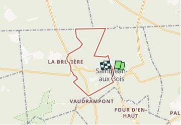
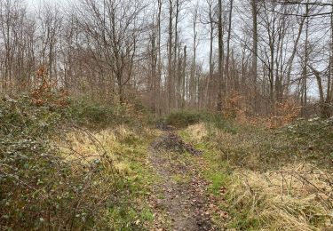
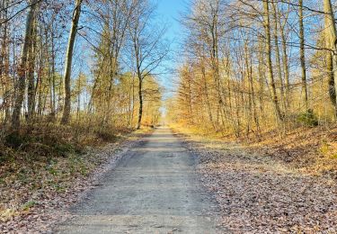
Trail Walking of 11 km to be discovered at Hauts-de-France, Oise, Saint-Jean-aux-Bois. This trail is proposed by José800.
Description
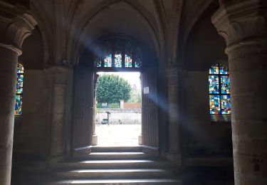
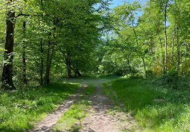
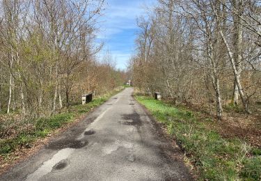
beaux villages fleuries , étang St Périne dans une jolie foret de Compiègne . L Abbaye du XlII siècle a Saint Jean -aux - bois abrite une orgue exceptionnel en France , 1100 tuyaux , 3 claviers , 1 pédaliers et des jeux numériques .
Positioning
Country:
France
Region :
Hauts-de-France
Department/Province :
Oise
Municipality :
Saint-Jean-aux-Bois
Location:
Unknown
Start:(Dec)
Start:(UTM)
493127 ; 5466013 (31U) N.
Comments
Trails nearby
![Trail On foot Pierrefonds - Le Voliard - Photo](https://media.geolcdn.com/t/375/260/4781613a-076f-4ad8-be25-8d021ddb8fa3.jpeg&format=jpg&maxdim=2)
![On foot On foot](https://static1.geolcdn.com/sitytour/trail-icons/100.png)
Le Voliard
On foot
Easy
(1)
Pierrefonds,
Hauts-de-France,
Oise,
France
![](/images/other/stat-length.png)
5.2 km | 6.4 km-effort
1h 27min
![](https://static1.geolcdn.com/siteimages/upload/files/16400158638029165_repeat_loop_refresh_sync_direction_icon.png)
No
![Trail On foot Saint-Jean-aux-Bois - Promenade du Chêne de Saint-Jean - Photo](https://media.geolcdn.com/t/375/260/660f8de9-0f4a-4545-bfd3-d9c82cefa146.jpeg&format=jpg&maxdim=2)
![On foot On foot](https://static1.geolcdn.com/sitytour/trail-icons/100.png)
Promenade du Chêne de Saint-Jean
On foot
Easy
Saint-Jean-aux-Bois,
Hauts-de-France,
Oise,
France
![](/images/other/stat-length.png)
5.7 km | 6.5 km-effort
1h 28min
![](https://static1.geolcdn.com/siteimages/upload/files/16400158638029165_repeat_loop_refresh_sync_direction_icon.png)
No
![Trail Walking Saint-Jean-aux-Bois - SAINT JEAN AUX BOIS, le village et les bois - Photo](https://media.geolcdn.com/t/375/260/cbd4d574-4b06-4403-8920-57abc85ecbc5.jpg&format=jpg&maxdim=2)
![Walking Walking](https://static1.geolcdn.com/sitytour/trail-icons/101.png)
SAINT JEAN AUX BOIS, le village et les bois
Walking
Easy
Saint-Jean-aux-Bois,
Hauts-de-France,
Oise,
France
![](/images/other/stat-length.png)
4.6 km | 5.2 km-effort
1h 11min
![](https://static1.geolcdn.com/siteimages/upload/files/16400158638029165_repeat_loop_refresh_sync_direction_icon.png)
Yes
![Trail Walking Vieux-Moulin - Rando douce Vieux moulin 14/8/2022 - Photo](https://media.geolcdn.com/t/375/260/ext.jpg?maxdim=2&url=https%3A%2F%2Fstatic1.geolcdn.com%2Fsiteimages%2Fupload%2Ffiles%2F1553511878bg_sport_marche.png)
![Walking Walking](https://static1.geolcdn.com/sitytour/trail-icons/101.png)
Rando douce Vieux moulin 14/8/2022
Walking
Medium
(1)
Vieux-Moulin,
Hauts-de-France,
Oise,
France
![](/images/other/stat-length.png)
8.7 km | 10.1 km-effort
2h 14min
![](https://static1.geolcdn.com/siteimages/upload/files/16400158638029165_repeat_loop_refresh_sync_direction_icon.png)
Yes
![Trail Walking Vieux-Moulin - Gorges du Han - ATPC ARVAL - Photo](https://media.geolcdn.com/t/375/260/ext.jpg?maxdim=2&url=https%3A%2F%2Fstatic1.geolcdn.com%2Fsiteimages%2Fupload%2Ffiles%2F1553511878bg_sport_marche.png)
![Walking Walking](https://static1.geolcdn.com/sitytour/trail-icons/101.png)
Gorges du Han - ATPC ARVAL
Walking
Very easy
(1)
Vieux-Moulin,
Hauts-de-France,
Oise,
France
![](/images/other/stat-length.png)
13.2 km | 16 km-effort
2h 42min
![](https://static1.geolcdn.com/siteimages/upload/files/16400158638029165_repeat_loop_refresh_sync_direction_icon.png)
Yes
![Trail Walking Compiègne - en Forêt de Compiègne_50_les Routes des Beaux Monts, de Morpigny et des Nymphes - Photo](https://media.geolcdn.com/t/375/260/9c55d9c0-6825-4d4d-9591-f5323b93b433.jpg&format=jpg&maxdim=2)
![Walking Walking](https://static1.geolcdn.com/sitytour/trail-icons/101.png)
en Forêt de Compiègne_50_les Routes des Beaux Monts, de Morpigny et des Nymphes
Walking
Very difficult
Compiègne,
Hauts-de-France,
Oise,
France
![](/images/other/stat-length.png)
17 km | 20 km-effort
5h 2min
![](https://static1.geolcdn.com/siteimages/upload/files/16400158638029165_repeat_loop_refresh_sync_direction_icon.png)
Yes
![Trail Walking Compiègne - en forêt de Compiègne_48_sur les Routes de la Mariolle et du Grand Veneur - Photo](https://media.geolcdn.com/t/375/260/7316114b-cb1c-453b-b79a-8461b3c901b1.jpg&format=jpg&maxdim=2)
![Walking Walking](https://static1.geolcdn.com/sitytour/trail-icons/101.png)
en forêt de Compiègne_48_sur les Routes de la Mariolle et du Grand Veneur
Walking
Very difficult
Compiègne,
Hauts-de-France,
Oise,
France
![](/images/other/stat-length.png)
17 km | 19.9 km-effort
5h 21min
![](https://static1.geolcdn.com/siteimages/upload/files/16400158638029165_repeat_loop_refresh_sync_direction_icon.png)
Yes
![Trail Walking Saint-Jean-aux-Bois - Saint Jean au Bois 13,4 km - Photo](https://media.geolcdn.com/t/375/260/ddfb4125-3dc9-462c-8144-537eda5ffbb6.jpg&format=jpg&maxdim=2)
![Walking Walking](https://static1.geolcdn.com/sitytour/trail-icons/101.png)
Saint Jean au Bois 13,4 km
Walking
Easy
Saint-Jean-aux-Bois,
Hauts-de-France,
Oise,
France
![](/images/other/stat-length.png)
13.4 km | 16.3 km-effort
3h 51min
![](https://static1.geolcdn.com/siteimages/upload/files/16400158638029165_repeat_loop_refresh_sync_direction_icon.png)
Yes
![Walking Walking](https://static1.geolcdn.com/sitytour/trail-icons/101.png)
en forêt de Compiègne_45_sur les Routes de Morienval et de Champlieu
Walking
Medium
Lacroix-Saint-Ouen,
Hauts-de-France,
Oise,
France
![](/images/other/stat-length.png)
15 km | 17.4 km-effort
4h 29min
![](https://static1.geolcdn.com/siteimages/upload/files/16400158638029165_repeat_loop_refresh_sync_direction_icon.png)
Yes