![](/images/other/stat-length.png)
![Trail Walking Nozay - SityTrail - JC 01 19 km Nozay Marcoussis - Photo](https://media.geolcdn.com/t/1900/400/ext.pjpeg?maxdim=2&url=https%3A%2F%2Fstatic1.geolcdn.com%2Fsiteimages%2Fupload%2Ffiles%2F1553511878bg_sport_marche.png)
SityTrail - JC 01 19 km Nozay Marcoussis
Les 1000 pattes
Club randonnées SERVON
![Length](/images/other/stat-length.png)
Length
18.2 km
![Max alt](https://static1.geolcdn.com/siteimages/upload/files/1508320355ic_sort_altitude_max_24dp.png)
Max alt
169 m
![Uphill gradient](https://static1.geolcdn.com/siteimages/upload/files/1508320355ic_sort_den_pos_24dp.png)
Uphill gradient
258 m
![Km-Effort](/images/other/stat-length.png)
Km-Effort
22 km
![Min alt](https://static1.geolcdn.com/siteimages/upload/files/1508320355ic_sort_altitude_min_24dp.png)
Min alt
69 m
![Downhill gradient](https://static1.geolcdn.com/siteimages/upload/files/1508320355ic_sort_den_neg_24dp.png)
Downhill gradient
257 m
![Boucle](https://static1.geolcdn.com/siteimages/upload/files/16400158638029165_repeat_loop_refresh_sync_direction_icon.png)
Boucle
Yes
Creation date :
2023-07-31 13:15:35.756
Updated on :
2023-07-31 13:56:44.293
![Walking](https://static1.geolcdn.com/sitytour/trail-icons/101.png)
5h00
Difficulty : Difficult
![Scan this QR Code to open this trail in the SityTrail application](https://capi.geolives.com/qq0zvz2zws4bq2lad0pu/sitytour/trails/3753718/qr.png?size=200)
FREE GPS app for hiking
About
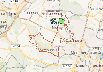
Trail Walking of 18.2 km to be discovered at Ile-de-France, Essonne, Nozay. This trail is proposed by Les 1000 pattes.
Description
Parking de la mairie et de l'église (place de la Mairie/Rue du Gros Chêne) de Nozay
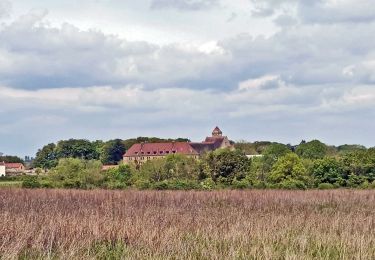
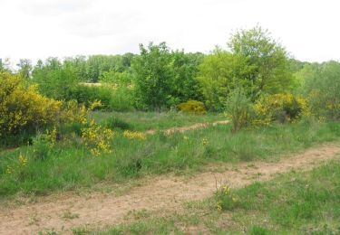
Paysages divers , centre national rugby de Marcoussis
Trajet: Servon--> Nozay 42km
Positioning
Country:
France
Region :
Ile-de-France
Department/Province :
Essonne
Municipality :
Nozay
Location:
Unknown
Start:(Dec)
Start:(UTM)
444260 ; 5389952 (31U) N.
Comments
Trails nearby
![Trail Walking Ballainvilliers - GRP CV-IDF 2023 - Photo](https://media.geolcdn.com/t/375/260/0b5967b2-2c8e-4675-a0f7-553186b66225.jpg&format=jpg&maxdim=2)
![Walking Walking](https://static1.geolcdn.com/sitytour/trail-icons/101.png)
GRP CV-IDF 2023
Walking
Very difficult
(1)
Ballainvilliers,
Ile-de-France,
Essonne,
France
![](/images/other/stat-length.png)
15.5 km | 19.1 km-effort
4h 20min
![](https://static1.geolcdn.com/siteimages/upload/files/16400158638029165_repeat_loop_refresh_sync_direction_icon.png)
No
![Trail Walking Marcoussis - Autour de Leuville sur Orge - Photo](https://media.geolcdn.com/t/375/260/ext.jpg?maxdim=2&url=https%3A%2F%2Fservices.sitytrail.com%2FGeolivesWS%2FDownloadMedia.ashx%3FTrailID%3D105827%26Media%3D9782_6.jpg)
![Walking Walking](https://static1.geolcdn.com/sitytour/trail-icons/101.png)
Autour de Leuville sur Orge
Walking
Medium
(1)
Marcoussis,
Ile-de-France,
Essonne,
France
![](/images/other/stat-length.png)
27 km | 32 km-effort
5h 30min
![](https://static1.geolcdn.com/siteimages/upload/files/16400158638029165_repeat_loop_refresh_sync_direction_icon.png)
Yes
![Trail Walking Saulx-les-Chartreux - Saulx les Chartreux vers Ville du Bois - Photo](https://media.geolcdn.com/t/375/260/ext.jpg?maxdim=2&url=https%3A%2F%2Fservices.sitytrail.com%2FGeolivesWS%2FDownloadMedia.ashx%3FTrailID%3D103772%26Media%3D6532_3.jpg)
![Walking Walking](https://static1.geolcdn.com/sitytour/trail-icons/101.png)
Saulx les Chartreux vers Ville du Bois
Walking
Medium
(1)
Saulx-les-Chartreux,
Ile-de-France,
Essonne,
France
![](/images/other/stat-length.png)
9.6 km | 12.2 km-effort
2h 30min
![](https://static1.geolcdn.com/siteimages/upload/files/16400158638029165_repeat_loop_refresh_sync_direction_icon.png)
Yes
![Trail Walking Orsay - Le long de l yvette - Photo](https://media.geolcdn.com/t/375/260/ext.jpg?maxdim=2&url=https%3A%2F%2Fservices.sitytrail.com%2FGeolivesWS%2FDownloadMedia.ashx%3FTrailID%3D427704%26Media%3Dfix__20150530150046.jpg)
![Walking Walking](https://static1.geolcdn.com/sitytour/trail-icons/101.png)
Le long de l yvette
Walking
Very easy
(1)
Orsay,
Ile-de-France,
Essonne,
France
![](/images/other/stat-length.png)
8.5 km | 9.4 km-effort
2h 43min
![](https://static1.geolcdn.com/siteimages/upload/files/16400158638029165_repeat_loop_refresh_sync_direction_icon.png)
Yes
![Trail Walking Orsay - Orsay Campus - Photo](https://media.geolcdn.com/t/375/260/ext.jpg?maxdim=2&url=https%3A%2F%2Fservices.sitytrail.com%2FGeolivesWS%2FDownloadMedia.ashx%3FTrailID%3D103330%26Media%3D5326_2.jpg)
![Walking Walking](https://static1.geolcdn.com/sitytour/trail-icons/101.png)
Orsay Campus
Walking
Medium
(1)
Orsay,
Ile-de-France,
Essonne,
France
![](/images/other/stat-length.png)
10.9 km | 13.3 km-effort
3h 30min
![](https://static1.geolcdn.com/siteimages/upload/files/16400158638029165_repeat_loop_refresh_sync_direction_icon.png)
Yes
![Trail Walking Marcoussis - Boucle 21 km autour de Marcoussis - Photo](https://media.geolcdn.com/t/375/260/84e197ac-c319-47fa-bb7d-3df31ddcaec5.jpg&format=jpg&maxdim=2)
![Walking Walking](https://static1.geolcdn.com/sitytour/trail-icons/101.png)
Boucle 21 km autour de Marcoussis
Walking
Very difficult
Marcoussis,
Ile-de-France,
Essonne,
France
![](/images/other/stat-length.png)
21 km | 24 km-effort
5h 28min
![](https://static1.geolcdn.com/siteimages/upload/files/16400158638029165_repeat_loop_refresh_sync_direction_icon.png)
Yes
![Trail Walking Brétigny-sur-Orge - Boucle Bretigny - Arpajon - Photo](https://media.geolcdn.com/t/375/260/610d9a07-a424-4037-8ef6-13d7a5819263.jpg&format=jpg&maxdim=2)
![Walking Walking](https://static1.geolcdn.com/sitytour/trail-icons/101.png)
Boucle Bretigny - Arpajon
Walking
Difficult
Brétigny-sur-Orge,
Ile-de-France,
Essonne,
France
![](/images/other/stat-length.png)
30 km | 36 km-effort
6h 19min
![](https://static1.geolcdn.com/siteimages/upload/files/16400158638029165_repeat_loop_refresh_sync_direction_icon.png)
Yes
![Trail Walking Longjumeau - Boucle 23 km autour de Longjumeau - Photo](https://media.geolcdn.com/t/375/260/a98102b6-d183-4b5b-8bb0-fb39230ce35c.jpg&format=jpg&maxdim=2)
![Walking Walking](https://static1.geolcdn.com/sitytour/trail-icons/101.png)
Boucle 23 km autour de Longjumeau
Walking
Medium
Longjumeau,
Ile-de-France,
Essonne,
France
![](/images/other/stat-length.png)
23 km | 27 km-effort
4h 48min
![](https://static1.geolcdn.com/siteimages/upload/files/16400158638029165_repeat_loop_refresh_sync_direction_icon.png)
Yes
![Trail On foot Villebon-sur-Yvette - PR 13 - Photo](https://media.geolcdn.com/t/375/260/dc9d90c6-b805-4f4b-90f6-97eb24809025.jpeg&format=jpg&maxdim=2)
![On foot On foot](https://static1.geolcdn.com/sitytour/trail-icons/100.png)
PR 13
On foot
Easy
Villebon-sur-Yvette,
Ile-de-France,
Essonne,
France
![](/images/other/stat-length.png)
11.3 km | 14.5 km-effort
3h 17min
![](https://static1.geolcdn.com/siteimages/upload/files/16400158638029165_repeat_loop_refresh_sync_direction_icon.png)
No