![](/images/other/stat-length.png)
![Trail Nordic walking Dommartin-sous-Amance - Dommartin-sous-Amance 9 360m +194m - Photo](https://media.geolcdn.com/t/1900/400/ext.pjpeg?maxdim=2&url=https%3A%2F%2Fstatic1.geolcdn.com%2Fsiteimages%2Fupload%2Ffiles%2F1545311037marcheuse_200dpi.jpg)
Dommartin-sous-Amance 9 360m +194m
DanielROLLET
User
![Length](/images/other/stat-length.png)
Length
9.3 km
![Max alt](https://static1.geolcdn.com/siteimages/upload/files/1508320355ic_sort_altitude_max_24dp.png)
Max alt
371 m
![Uphill gradient](https://static1.geolcdn.com/siteimages/upload/files/1508320355ic_sort_den_pos_24dp.png)
Uphill gradient
186 m
![Km-Effort](/images/other/stat-length.png)
Km-Effort
11.8 km
![Min alt](https://static1.geolcdn.com/siteimages/upload/files/1508320355ic_sort_altitude_min_24dp.png)
Min alt
202 m
![Downhill gradient](https://static1.geolcdn.com/siteimages/upload/files/1508320355ic_sort_den_neg_24dp.png)
Downhill gradient
187 m
![Boucle](https://static1.geolcdn.com/siteimages/upload/files/16400158638029165_repeat_loop_refresh_sync_direction_icon.png)
Boucle
Yes
Creation date :
2023-07-31 07:24:44.526
Updated on :
2023-07-31 14:42:48.849
![Nordic walking](https://static1.geolcdn.com/sitytour/trail-icons/102.png)
2h15
Difficulty : Easy
![Scan this QR Code to open this trail in the SityTrail application](https://capi.geolives.com/qq0zvz2zws4bq2lad0pu/sitytour/trails/3753438/qr.png?size=200)
FREE GPS app for hiking
About
Trail Nordic walking of 9.3 km to be discovered at Grand Est, Meurthe-et-Moselle, Dommartin-sous-Amance. This trail is proposed by DanielROLLET.
Description
2023 07 31- MND Saulxures Rando 54 - 12 participants
9h20 à 11h40 - Temps couvert mais calme
Une petite erreur à la croix des pestiférés. ( 500m)
Beau coup de temps perdu à l'arrière...
Positioning
Country:
France
Region :
Grand Est
Department/Province :
Meurthe-et-Moselle
Municipality :
Dommartin-sous-Amance
Location:
Unknown
Start:(Dec)
Start:(UTM)
297327 ; 5402364 (32U) N.
Comments
Trails nearby
![Trail On foot Agincourt - Circuit M - Photo](https://media.geolcdn.com/t/375/260/af3027bd-6d38-4135-8a9f-8cca4de624d0.jpeg&format=jpg&maxdim=2)
![On foot On foot](https://static1.geolcdn.com/sitytour/trail-icons/100.png)
Circuit M
On foot
Easy
Agincourt,
Grand Est,
Meurthe-et-Moselle,
France
![](/images/other/stat-length.png)
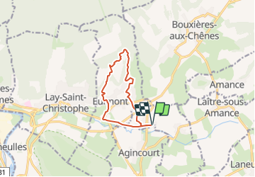
13.3 km | 17.8 km-effort
4h 3min
![](https://static1.geolcdn.com/siteimages/upload/files/16400158638029165_repeat_loop_refresh_sync_direction_icon.png)
No
![Trail On foot Lay-Saint-Christophe - Circuit L - Photo](https://media.geolcdn.com/t/375/260/8edc069d-a9b9-439a-9f46-3e2f5923a387.jpeg&format=jpg&maxdim=2)
![On foot On foot](https://static1.geolcdn.com/sitytour/trail-icons/100.png)
Circuit L
On foot
Easy
Lay-Saint-Christophe,
Grand Est,
Meurthe-et-Moselle,
France
![](/images/other/stat-length.png)
14.7 km | 18.5 km-effort
4h 11min
![](https://static1.geolcdn.com/siteimages/upload/files/16400158638029165_repeat_loop_refresh_sync_direction_icon.png)
Yes
![Trail Walking Eulmont - 2020-12-11_18h42m13_Eulmont_La tour du Crany_10kms - Photo](https://media.geolcdn.com/t/375/260/ext.jpg?maxdim=2&url=https%3A%2F%2Fstatic1.geolcdn.com%2Fsiteimages%2Fupload%2Ffiles%2F1553511878bg_sport_marche.png)
![Walking Walking](https://static1.geolcdn.com/sitytour/trail-icons/101.png)
2020-12-11_18h42m13_Eulmont_La tour du Crany_10kms
Walking
Difficult
(2)
Eulmont,
Grand Est,
Meurthe-et-Moselle,
France
![](/images/other/stat-length.png)
9.6 km | 12.6 km-effort
2h 51min
![](https://static1.geolcdn.com/siteimages/upload/files/16400158638029165_repeat_loop_refresh_sync_direction_icon.png)
Yes
![Trail Walking Dommartemont - Dommartemont - Photo](https://media.geolcdn.com/t/375/260/8cd51545-df85-4589-bd14-ed6d542f080f.jpg&format=jpg&maxdim=2)
![Walking Walking](https://static1.geolcdn.com/sitytour/trail-icons/101.png)
Dommartemont
Walking
Medium
Dommartemont,
Grand Est,
Meurthe-et-Moselle,
France
![](/images/other/stat-length.png)
29 km | 34 km-effort
3h 5min
![](https://static1.geolcdn.com/siteimages/upload/files/16400158638029165_repeat_loop_refresh_sync_direction_icon.png)
No
![Trail Hybrid bike Seichamps - Tonnoy - Photo](https://media.geolcdn.com/t/375/260/ext.jpg?maxdim=2&url=https%3A%2F%2Fstatic1.geolcdn.com%2Fsiteimages%2Fupload%2Ffiles%2F1524743154velo.jpg)
![Hybrid bike Hybrid bike](https://static1.geolcdn.com/sitytour/trail-icons/203.png)
Tonnoy
Hybrid bike
Medium
(1)
Seichamps,
Grand Est,
Meurthe-et-Moselle,
France
![](/images/other/stat-length.png)
54 km | 61 km-effort
3h 42min
![](https://static1.geolcdn.com/siteimages/upload/files/16400158638029165_repeat_loop_refresh_sync_direction_icon.png)
Yes
![Trail Walking Bouxières-aux-Chênes - tour crany 29/5/2019 - Photo](https://media.geolcdn.com/t/375/260/ext.jpg?maxdim=2&url=https%3A%2F%2Fstatic1.geolcdn.com%2Fsiteimages%2Fupload%2Ffiles%2F1553511878bg_sport_marche.png)
![Walking Walking](https://static1.geolcdn.com/sitytour/trail-icons/101.png)
tour crany 29/5/2019
Walking
Very easy
(1)
Bouxières-aux-Chênes,
Grand Est,
Meurthe-et-Moselle,
France
![](/images/other/stat-length.png)
11.1 km | 14 km-effort
3h 42min
![](https://static1.geolcdn.com/siteimages/upload/files/16400158638029165_repeat_loop_refresh_sync_direction_icon.png)
Yes
![Trail Walking Bouxières-aux-Chênes - Amance blanzey boucles des amance - Photo](https://media.geolcdn.com/t/375/260/682c5f23-15d3-4fdf-8eeb-a74f6e61dda1.jpg&format=jpg&maxdim=2)
![Walking Walking](https://static1.geolcdn.com/sitytour/trail-icons/101.png)
Amance blanzey boucles des amance
Walking
Medium
Bouxières-aux-Chênes,
Grand Est,
Meurthe-et-Moselle,
France
![](/images/other/stat-length.png)
9.2 km | 12.5 km-effort
4h 52min
![](https://static1.geolcdn.com/siteimages/upload/files/16400158638029165_repeat_loop_refresh_sync_direction_icon.png)
Yes
![Trail Walking Bouxières-aux-Chênes - bouxieres aux chênes - Blanzey - Photo](https://media.geolcdn.com/t/375/260/53a8e14a-fcca-41b7-ba10-e0d8828d01da.jpg&format=jpg&maxdim=2)
![Walking Walking](https://static1.geolcdn.com/sitytour/trail-icons/101.png)
bouxieres aux chênes - Blanzey
Walking
Medium
Bouxières-aux-Chênes,
Grand Est,
Meurthe-et-Moselle,
France
![](/images/other/stat-length.png)
12 km | 14.7 km-effort
19h 32min
![](https://static1.geolcdn.com/siteimages/upload/files/16400158638029165_repeat_loop_refresh_sync_direction_icon.png)
Yes
![Trail Walking Bouxières-aux-Chênes - bouxieres aux chênes - la tour de crany - Photo](https://media.geolcdn.com/t/375/260/a86bdc52-4815-4222-8ee6-18cca8f402a0.jpg&format=jpg&maxdim=2)
![Walking Walking](https://static1.geolcdn.com/sitytour/trail-icons/101.png)
bouxieres aux chênes - la tour de crany
Walking
Easy
Bouxières-aux-Chênes,
Grand Est,
Meurthe-et-Moselle,
France
![](/images/other/stat-length.png)
11.2 km | 14.2 km-effort
4h 52min
![](https://static1.geolcdn.com/siteimages/upload/files/16400158638029165_repeat_loop_refresh_sync_direction_icon.png)
Yes