Trail Walking Saint-Jean-d'Aulps - col de Ratti - Photo
 davvin13
davvin13

User

© OpenStreetMap contributors
Length
Length
7.3 km
Max alt
Max alt
1969 m
Uphill gradient
Uphill gradient
523 m
Km-Effort
Km-Effort  
14.7 km
Min alt
Min alt
1340 m
Downhill gradient
Downhill gradient
650 m
Boucle
Boucle
No
Creation date :
2023-07-27 08:51:52.921
Updated on :
2023-07-27 13:38:23.804

(0 Reviews)

Walking
Walking
4h20
Difficulty : Difficult

Scan this QR Code to open this trail in the SityTrail application

FREE GPS app for hiking

Logo SityTrail SityTrail

IGN / Geographical institutes

Download SityTrail from the App Store Download SityTrail from Google Play

Logo SityTrail SityTrail World

The world is yours!

Download SityTrail from the App Store Download SityTrail from Google Play Download SityTrail on Huawei AppGallery

About

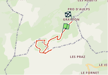
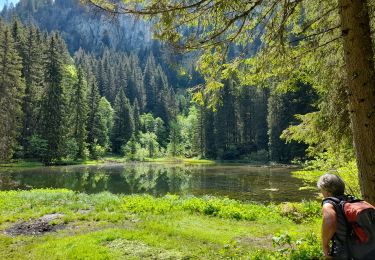
Trail Walking of 7.3 km to be discovered at Auvergne-Rhône-Alpes, Upper Savoy, Saint-Jean-d'Aulps. This trail is proposed by davvin13.

Elevation profile

Photos

Positioning

Country:
France
Region :
Auvergne-Rhône-Alpes
Department/Province :
Upper Savoy
Municipality :
Saint-Jean-d'Aulps
Location:
Unknown
Start:(UTM)
317172 ; 5118690 (32T) N.

Trails nearby

Trail Nordic walking Bellevaux - tour du roc - Photo
Nordic walking
PierreBellevaux

Nordic walking

Medium
(1)
Bellevaux, Auvergne-Rhône-Alpes, Upper Savoy, France
26 km | 53 km-effort
4h 7min
Yes
Trail Walking Bellevaux - La Haute Pointe 1968m, depuis le Plan des Rasses - Photo
Walking
tracegps

Walking

Medium
(1)
Bellevaux, Auvergne-Rhône-Alpes, Upper Savoy, France
9.8 km | 21 km-effort
5h 30min
Yes
Trail Walking Mieussy - La Pointe de Chavasse, 2012m - Photo
Walking
tracegps

Walking

Difficult
(1)
Mieussy, Auvergne-Rhône-Alpes, Upper Savoy, France
9.9 km | 18.2 km-effort
4h 45min
Yes
Trail Walking Morzine - morzine la cime de Nyon  - Photo
Walking
labarone

Walking

Difficult
Morzine, Auvergne-Rhône-Alpes, Upper Savoy, France
14.6 km | 22 km-effort
5h 59min
No
Trail Walking Les Gets - morzine col du mont chery - Photo
Walking
labarone

Walking

Very difficult
Les Gets, Auvergne-Rhône-Alpes, Upper Savoy, France
16.6 km | 30 km-effort
6h 45min
Yes
Trail Walking Taninges - Balade autour de Beauregard - Photo
Walking
000151.528cee2ba5ea499bb7720e62b4a3eb52.0056

Walking

Medium
Taninges, Auvergne-Rhône-Alpes, Upper Savoy, France
5.9 km | 10.5 km-effort
1h 39min
Yes
Trail Nordic walking Morzine - Tour pleney - Photo
Nordic walking
vincentdr

Nordic walking

Medium
Morzine, Auvergne-Rhône-Alpes, Upper Savoy, France
6 km | 9.5 km-effort
2h 6min
Yes
Trail Walking Mieussy - CHABLAIS: TOUR DE LA POINTE DE CHALUNE - Photo
Walking
djeepee74

Walking

Medium
Mieussy, Auvergne-Rhône-Alpes, Upper Savoy, France
12.2 km | 23 km-effort
5h 0min
Yes
Trail On foot Saint-Jean-d'Aulps - Tour des Portes du Soleil - Photo
On foot
GUIDE+

On foot

Very difficult
Saint-Jean-d'Aulps, Auvergne-Rhône-Alpes, Upper Savoy, France
34 km | 66 km-effort
15h 3min
No


Close
My subscriptions