


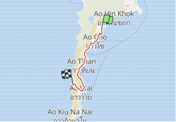
kho Samed, sentier littoral

MathieuBourgois
User

Length
3.6 km

Max alt
42 m

Uphill gradient
78 m
Km-Effort
4.5 km

Min alt
0 m

Downhill gradient
60 m
Boucle
No
Creation date :
2023-07-26 02:30:13.684
Updated on :
2023-07-26 02:30:18.493
1h01
Difficulty : Easy

FREE GPS app for hiking
 SityTrail
IGN / Geographical institutes
SityTrail World
The world is yours!
About
Trail Walking of 3.6 km to be discovered at Rayong Province. This trail is proposed by MathieuBourgois.
Positioning
Country:
Thailand
Region :
Rayong Province
Department/Province :
Unknown
Municipality :
Unknown
Location:
Unknown
Start:(Dec)
Start:(UTM)
766833 ; 1389841 (47P) N.
Comments
Trails nearby