Trail Motorbike Le Barroux - MOTO TOUR AIALA PATXI - Photo
 patxargi
patxargi

User

© OpenStreetMap contributors
Length
Length
114 km
Max alt
Max alt
1904 m
Uphill gradient
Uphill gradient
3027 m
Km-Effort
Km-Effort  
154 km
Min alt
Min alt
265 m
Downhill gradient
Downhill gradient
2996 m
Boucle
Boucle
No
Creation date :
2023-07-24 07:30:16.795
Updated on :
2023-07-24 14:21:06.424

(0 Reviews)

Motorbike
Motorbike
0m
Difficulty : Medium

Scan this QR Code to open this trail in the SityTrail application

FREE GPS app for hiking

Logo SityTrail SityTrail

IGN / Geographical institutes

Download SityTrail from the App Store Download SityTrail from Google Play

Logo SityTrail SityTrail World

The world is yours!

Download SityTrail from the App Store Download SityTrail from Google Play Download SityTrail on Huawei AppGallery

About

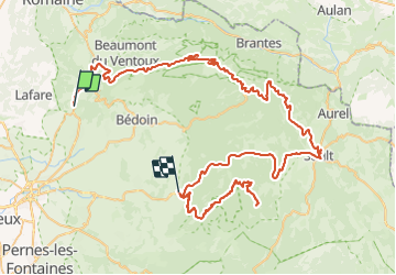
Trail Motorbike of 114 km to be discovered at Provence-Alpes-Côte d'Azur, Vaucluse, Le Barroux. This trail is proposed by patxargi.

Description

Depart Avignon----Mallaucene ----VENTOUX------descente vers SAULT-----Remonté gorges de la nesque.....descente par le même chemin......ETXEA

Elevation profile

Positioning

Country:
France
Region :
Provence-Alpes-Côte d'Azur
Department/Province :
Vaucluse
Municipality :
Le Barroux
Location:
Unknown
Start:(UTM)
668242 ; 4889090 (31T) N.

Trails nearby

Trail Walking Lafare - Le tour du Grand Montmirail - Lafare - Photo
Walking
tracegps

Walking

Medium
(3)
Lafare, Provence-Alpes-Côte d'Azur, Vaucluse, France
9.1 km | 13.9 km-effort
2h 30min
Yes
Trail Walking Saint-Hippolyte-le-Graveyron - Le graveron petit circuit  - Photo
Walking
Vero7684

Walking

Easy
(1)
Saint-Hippolyte-le-Graveyron, Provence-Alpes-Côte d'Azur, Vaucluse, France
5.7 km | 8.8 km-effort
2h 5min
Yes
Trail Walking Lafare - Une approche des Dentelles de Montmirail - Photo
Walking
tracegps

Walking

Medium
(2)
Lafare, Provence-Alpes-Côte d'Azur, Vaucluse, France
6.6 km | 11.4 km-effort
3h 0min
Yes
Trail Walking Le Barroux - Lac du Barroux - Photo
Walking
alainbarrot

Walking

Very easy
(2)
Le Barroux, Provence-Alpes-Côte d'Azur, Vaucluse, France
5.8 km | 8 km-effort
1h 42min
Yes
Trail Running Le Barroux - Sortie Barroux - Photo
Running
ssi6159

Running

Very easy
(1)
Le Barroux, Provence-Alpes-Côte d'Azur, Vaucluse, France
12.9 km | 20 km-effort
1h 47min
Yes
Trail Walking Malaucène - Campagne de Malaucène - Photo
Walking
tracegps

Walking

Easy
(2)
Malaucène, Provence-Alpes-Côte d'Azur, Vaucluse, France
6.6 km | 8.1 km-effort
1h 30min
Yes
Trail Walking Le Barroux - Les Crêtes du Graveyron par l'écluse de la Falque - Photo
Walking
supercolas

Walking

Difficult
Le Barroux, Provence-Alpes-Côte d'Azur, Vaucluse, France
9 km | 13.4 km-effort
2h 57min
Yes
Trail Walking Malaucène - Autour de Malaucène  - Photo
Walking
GUIDE
nadinebondoux

Walking

Difficult
Malaucène, Provence-Alpes-Côte d'Azur, Vaucluse, France
18.3 km | 27 km-effort
5h 53min
Yes
Trail Walking Malaucène - Malaucène  - Photo
Walking
GUIDE
Roger Philippe Wallez

Walking

Very difficult
Malaucène, Provence-Alpes-Côte d'Azur, Vaucluse, France
18.6 km | 27 km-effort
6h 32min
Yes


Close
My subscriptions