


Le glacier de svartissen

Morelli
User
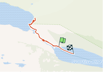

Length
7.8 km

Max alt
517 m

Uphill gradient
432 m
Km-Effort
13.6 km

Min alt
73 m

Downhill gradient
438 m
Boucle
No
Creation date :
2023-07-21 07:32:43.837
Updated on :
2023-07-22 17:03:09.761
2h43
Difficulty : Medium

FREE GPS app for hiking
 SityTrail
IGN / Geographical institutes
SityTrail World
The world is yours!
About
Trail Walking of 7.8 km to be discovered at Nordland. This trail is proposed by Morelli.
Positioning
Country:
Norway
Region :
Nordland
Department/Province :
Unknown
Municipality :
Unknown
Location:
Unknown
Start:(Dec)
Start:(UTM)
460912 ; 7376218 (33W) N.
Comments
Trails nearby