Trail On foot Vallière - Rando dite

Rando dite "Gour de Vaux"

 Surot
Surot

User

© OpenStreetMap contributors
Length
Length
10.6 km
Max alt
Max alt
603 m
Uphill gradient
Uphill gradient
206 m
Km-Effort
Km-Effort  
13.4 km
Min alt
Min alt
509 m
Downhill gradient
Downhill gradient
206 m
Boucle
Boucle
Yes
Creation date :
2023-07-21 14:32:10.133
Updated on :
2023-07-21 14:40:38.895

(1 Reviews)

On foot
On foot
3h02
Difficulty : Easy

Scan this QR Code to open this trail in the SityTrail application

FREE GPS app for hiking

Logo SityTrail SityTrail

IGN / Geographical institutes

Download SityTrail from the App Store Download SityTrail from Google Play

Logo SityTrail SityTrail World

The world is yours!

Download SityTrail from the App Store Download SityTrail from Google Play Download SityTrail on Huawei AppGallery

About

Trail On foot of 10.6 km to be discovered at New Aquitaine, Creuse, Vallière. This trail is proposed by Surot.

Description

Une dizaine de km en bords d'étangs, en forêt et au milieu des champs, en suivant bien les indications, trait jaune, de PR. Avant le pont de bois, prendre à droite vers le Gour en aller-retour puis on traverse le pont, circuit en sous bois très agréable passage aux rares maisons de Vaux puis retour vers le pt de départ avec malheureusement pas mal de cheminement sur route, mais beaux paysages , étang, vaches et chevaux

Elevation profile

Positioning

Country:
France
Region :
New Aquitaine
Department/Province :
Creuse
Municipality :
Vallière
Location:
Unknown
Start:(UTM)
422902 ; 5084618 (31T) N.

Comments

Please log in to post a review or rate the element


Très belle randonnée dans cette magnifique région doucement vallonnée et aux beaux villages et maisons de pierre. Sans difficultés importantes.


Trails nearby

Trail Walking Vallière - valliete - Photo
Walking
Martin Cassol

Walking

Medium
Vallière, New Aquitaine, Creuse, France
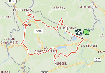
10.8 km | 13.4 km-effort
2h 38min
Yes
Trail Walking Vallière - Étang de Chabassière - Photo
Walking
martinjacque

Walking

Very easy
Vallière, New Aquitaine, Creuse, France
4.8 km | 5.5 km-effort
2h 0min
Yes
Trail Walking Banize - Beaubiat - Gaëc chèvres- La Roussille  - Photo
Walking
GUIDE
Ada11

Walking

Very easy
Banize, New Aquitaine, Creuse, France
5.6 km | 7 km-effort
1h 14min
Yes
Trail Walking Banize - Étape 3 juin 2024 - Photo
Walking
Pascal Bernaud

Walking

Very difficult
Banize, New Aquitaine, Creuse, France
21 km | 27 km-effort
7h 9min
No
Trail Walking Banize - Banize à Le Villard / Etape 2 - Photo
Walking
aucamus

Walking

Very difficult
Banize, New Aquitaine, Creuse, France
26 km | 33 km-effort
7h 28min
No
Trail Walking Vallière - Vallière-Pont des poupées - Photo
Walking
DanieleBocourt

Walking

Easy
Vallière, New Aquitaine, Creuse, France
3.8 km | 5 km-effort
1h 29min
Yes
Trail Walking Banize - Banize / Bourganeuf (Millevaches) étape 2 - Photo
Walking
aucamus

Walking

Very difficult
Banize, New Aquitaine, Creuse, France
30 km | 38 km-effort
8h 36min
No
Trail Walking Banize - GR4-55 - Banize - Chignat - Photo
Walking
Tournan

Walking

Very difficult
Banize, New Aquitaine, Creuse, France
22 km | 28 km-effort
6h 5min
No
Trail Walking Banize - GR46-02 - Banize - Faux la Montagne - Photo
Walking
Tournan

Walking

Medium
Banize, New Aquitaine, Creuse, France
30 km | 38 km-effort
8h 7min
No


Close
My subscriptions