Trail Walking Pralognan-la-Vanoise - Tour de la dent Parrachée - Photo
© OpenStreetMap contributors
Length
Length
58 km
Max alt
Max alt
2990 m
Uphill gradient
Uphill gradient
3271 m
Km-Effort
Km-Effort  
101 km
Min alt
Min alt
1424 m
Downhill gradient
Downhill gradient
3270 m
Boucle
Boucle
Yes
Creation date :
2023-07-20 21:08:15.016
Updated on :
2023-07-20 21:10:08.787

(0 Reviews)

Walking
Walking
23h03
Difficulty : Very difficult

Scan this QR Code to open this trail in the SityTrail application

FREE GPS app for hiking

Logo SityTrail SityTrail

IGN / Geographical institutes

Download SityTrail from the App Store Download SityTrail from Google Play

Logo SityTrail SityTrail World

The world is yours!

Download SityTrail from the App Store Download SityTrail from Google Play Download SityTrail on Huawei AppGallery

About

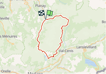
Trail Walking of 58 km to be discovered at Auvergne-Rhône-Alpes, Savoy, Pralognan-la-Vanoise. This trail is proposed by Camille Lecoutre 2.

Description

https://www.trekmag.com/micro-aventure-mini-trek-tour-glaciers-vanoise
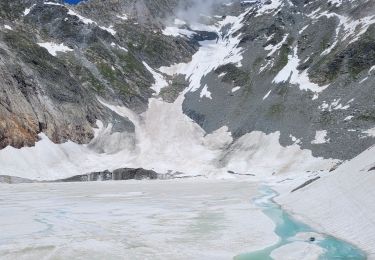
Étape 1 :Pralognan-la-Vanoise - Refuge du col de la Vanoise
3h /  1100 m / 7 km

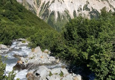
De Pralognan, monter aux Fontanettes (GR55) puis suivre les pistes pour entrer dans le vallon de la Glière. Passer le fameux lac des Vaches puis revenir vers le sud jusqu’au col de la Vanoise et son refuge. Une montée « sèche » pour le premier jour..
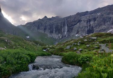
Étape 2 :Refuge du col de la Vanoise - Refuge de l'Arpont
5h /  500 m / -700 m / 14 km

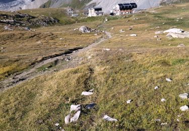
Suivre le GR55 qui descend versant est du col et le quitter pour traverser à flanc vers le sud dans le vallon de la Leisse. On rejoint le GR5 qui passe un petit col pour descendre aux petits lacs des Lozières. Continuer à flanc vers le sud jusqu’au refuge de l’Arpont.
Étape 3 : Refuge de l'Arpont - Refuge de la Dent Parrachée
7h /  1000 m / -800 m / 19 km

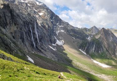
Suivre le GR5 vers le sud : il traverse tout le long à flanc de montagne avec multiples remontées et descentes jusqu’à gagner les pistes d’Aussois. On remonte au refuge de la Fournache (étape possible) puis à celui de la Parrachée (étape également possible au refuge du Fond-d’Aussois).
Étape 4 : Refuge de la Dent Parrachée - Pralognan
6h /  600 m / -1700 m / 18 km

Descendre dans le Fond-d’Aussois, passer au refuge puis monter au col d’Aussois. En descendre le versant nord (raide au départ, névés possibles) pour retrouver le GR55 au fond du vallon de Chavière. Le suivre intégralement jusqu’a Pralognan..

Elevation profile

Positioning

Country:
France
Region :
Auvergne-Rhône-Alpes
Department/Province :
Savoy
Municipality :
Pralognan-la-Vanoise
Location:
Unknown
Start:(UTM)
321655 ; 5027505 (32T) N.

Trails nearby

Trail Walking Pralognan-la-Vanoise - Pralognan - Les Prioux  Lac de Chalet Clou - Photo
Walking
countryjack

Walking

Easy
(3)
Pralognan-la-Vanoise, Auvergne-Rhône-Alpes, Savoy, France
11 km | 19.3 km-effort
4h 41min
Yes
Trail Walking Pralognan-la-Vanoise - Pralognan - la crête du mont Charvet - Photo
Walking
countryjack

Walking

Medium
(1)
Pralognan-la-Vanoise, Auvergne-Rhône-Alpes, Savoy, France
11.4 km | 24 km-effort
5h 1min
No
Trail Walking Val-Cenis - traversée Valette f faure - Photo
Walking
GUIDE
randodyssée

Walking

Difficult
Val-Cenis, Auvergne-Rhône-Alpes, Savoy, France
8.7 km | 13.8 km-effort
8h 24min
No
Trail Walking Pralognan-la-Vanoise - pointe de Leschaux - Photo
Walking
GUIDE
amiral13

Walking

Difficult
Pralognan-la-Vanoise, Auvergne-Rhône-Alpes, Savoy, France
12 km | 28 km-effort
5h 43min
Yes
Trail Walking Planay - la cascade de la Vuzelle - Photo
Walking
GUIDE
amiral13

Walking

Medium
Planay, Auvergne-Rhône-Alpes, Savoy, France
4.3 km | 10.4 km-effort
2h 21min
Yes
Trail Walking Pralognan-la-Vanoise - traversée des Fontanettes aux Prioux par le col du Grand marchet - Photo
Walking
GUIDE
amiral13

Walking

Difficult
Pralognan-la-Vanoise, Auvergne-Rhône-Alpes, Savoy, France
13.7 km | 30 km-effort
6h 51min
No
Trail Walking Pralognan-la-Vanoise - le lac de la patinoire - Photo
Walking
GUIDE
amiral13

Walking

Difficult
Pralognan-la-Vanoise, Auvergne-Rhône-Alpes, Savoy, France
11.3 km | 22 km-effort
5h 40min
Yes
Trail Walking Pralognan-la-Vanoise - col de napremont - Photo
Walking
GUIDE
amiral13

Walking

Easy
Pralognan-la-Vanoise, Auvergne-Rhône-Alpes, Savoy, France
9.4 km | 19.4 km-effort
4h 24min
Yes
Trail Walking Pralognan-la-Vanoise - 2022-06-28 Marche TGV Refuge Valette Pralognan - Photo
Walking
GUIDE
holtzv

Walking

Easy
Pralognan-la-Vanoise, Auvergne-Rhône-Alpes, Savoy, France
8.4 km | 16 km-effort
4h 20min
No


Close
My subscriptions