![](/images/other/stat-length.png)
![Trail Walking Hauteluce - Tour du Balcon des Côtes - Hauteluce - Photo](https://media.geolcdn.com/t/1900/400/ext.pjpeg?maxdim=2&url=https%3A%2F%2Fstatic1.geolcdn.com%2Fsiteimages%2Fupload%2Ffiles%2F1553511878bg_sport_marche.png)
Tour du Balcon des Côtes - Hauteluce
rapako
User
![Length](/images/other/stat-length.png)
Length
9.3 km
![Max alt](https://static1.geolcdn.com/siteimages/upload/files/1508320355ic_sort_altitude_max_24dp.png)
Max alt
1448 m
![Uphill gradient](https://static1.geolcdn.com/siteimages/upload/files/1508320355ic_sort_den_pos_24dp.png)
Uphill gradient
463 m
![Km-Effort](/images/other/stat-length.png)
Km-Effort
15.5 km
![Min alt](https://static1.geolcdn.com/siteimages/upload/files/1508320355ic_sort_altitude_min_24dp.png)
Min alt
1033 m
![Downhill gradient](https://static1.geolcdn.com/siteimages/upload/files/1508320355ic_sort_den_neg_24dp.png)
Downhill gradient
464 m
![Boucle](https://static1.geolcdn.com/siteimages/upload/files/16400158638029165_repeat_loop_refresh_sync_direction_icon.png)
Boucle
Yes
Creation date :
2023-07-20 07:35:42.927
Updated on :
2023-07-21 15:31:03.77
![Walking](https://static1.geolcdn.com/sitytour/trail-icons/101.png)
3h31
Difficulty : Medium
![Scan this QR Code to open this trail in the SityTrail application](https://capi.geolives.com/qq0zvz2zws4bq2lad0pu/sitytour/trails/3740953/qr.png?size=200)
FREE GPS app for hiking
About
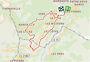
Trail Walking of 9.3 km to be discovered at Auvergne-Rhône-Alpes, Savoy, Hauteluce. This trail is proposed by rapako.
Description
Se garer sous le cimetière de Hauteluce
Une petite variante par rapport à la balade proposée par les Office de tourisme du Beaufortain pour minimiser un peu les parties bitumées, et apprécier encore un peu plus la vue sur le Massif du Mont Blanc sur le retour.
Positioning
Country:
France
Region :
Auvergne-Rhône-Alpes
Department/Province :
Savoy
Municipality :
Hauteluce
Location:
Unknown
Start:(Dec)
Start:(UTM)
312040 ; 5069038 (32T) N.
Comments
Trails nearby
![Trail Walking Hauteluce - sous Bisanne au lac des Saisies - Photo](https://media.geolcdn.com/t/375/260/ext.jpg?maxdim=2&url=https%3A%2F%2Fmedia.geolcdn.com%2Ff%2F37326f22-0206-4f0e-b1e9-16790c9e91ab.jpg)
![Walking Walking](https://static1.geolcdn.com/sitytour/trail-icons/101.png)
sous Bisanne au lac des Saisies
Walking
Medium
(1)
Hauteluce,
Auvergne-Rhône-Alpes,
Savoy,
France
![](/images/other/stat-length.png)
18.1 km | 28 km-effort
5h 36min
![](https://static1.geolcdn.com/siteimages/upload/files/16400158638029165_repeat_loop_refresh_sync_direction_icon.png)
Yes
![Trail Cycle Villard-sur-Doron - Boucle Villars le Mont Crest Voland Les Saisies - Photo](https://media.geolcdn.com/t/375/260/ext.jpg?maxdim=2&url=https%3A%2F%2Fservices.sitytrail.com%2FGeolivesWS%2FDownloadMedia.ashx%3FTrailID%3D855162%26Media%3D20171031161248.jpg)
![Cycle Cycle](https://static1.geolcdn.com/sitytour/trail-icons/200.png)
Boucle Villars le Mont Crest Voland Les Saisies
Cycle
Difficult
(1)
Villard-sur-Doron,
Auvergne-Rhône-Alpes,
Savoy,
France
![](/images/other/stat-length.png)
49 km | 74 km-effort
3h 42min
![](https://static1.geolcdn.com/siteimages/upload/files/16400158638029165_repeat_loop_refresh_sync_direction_icon.png)
Yes
![Trail Walking Hauteluce - Hauteluce - Photo](https://media.geolcdn.com/t/375/260/ext.jpg?maxdim=2&url=https%3A%2F%2Fstatic1.geolcdn.com%2Fsiteimages%2Fupload%2Ffiles%2F1553511878bg_sport_marche.png)
![Walking Walking](https://static1.geolcdn.com/sitytour/trail-icons/101.png)
Hauteluce
Walking
Very easy
(2)
Hauteluce,
Auvergne-Rhône-Alpes,
Savoy,
France
![](/images/other/stat-length.png)
4.1 km | 7.4 km-effort
1h 54min
![](https://static1.geolcdn.com/siteimages/upload/files/16400158638029165_repeat_loop_refresh_sync_direction_icon.png)
Yes
![Trail Walking Hauteluce - Mont Clocher - Photo](https://media.geolcdn.com/t/375/260/ext.jpg?maxdim=2&url=https%3A%2F%2Fservices.sitytrail.com%2FGeolivesWS%2FDownloadMedia.ashx%3FTrailID%3D85242%26Media%3D20110903163145.jpg)
![Walking Walking](https://static1.geolcdn.com/sitytour/trail-icons/101.png)
Mont Clocher
Walking
Very easy
(2)
Hauteluce,
Auvergne-Rhône-Alpes,
Savoy,
France
![](/images/other/stat-length.png)
7.3 km | 10.4 km-effort
1h 47min
![](https://static1.geolcdn.com/siteimages/upload/files/16400158638029165_repeat_loop_refresh_sync_direction_icon.png)
Yes
![Trail Walking Hauteluce - Croix de Coste - Mont Bisanne - Photo](https://media.geolcdn.com/t/375/260/ext.jpg?maxdim=2&url=https%3A%2F%2Fmedia.geolcdn.com%2Ff%2F6205cc33-0379-4e10-b69d-dfc0538206b7.jpg)
![Walking Walking](https://static1.geolcdn.com/sitytour/trail-icons/101.png)
Croix de Coste - Mont Bisanne
Walking
Very difficult
Hauteluce,
Auvergne-Rhône-Alpes,
Savoy,
France
![](/images/other/stat-length.png)
13.6 km | 23 km-effort
5h 6min
![](https://static1.geolcdn.com/siteimages/upload/files/16400158638029165_repeat_loop_refresh_sync_direction_icon.png)
Yes
![Trail Snowshoes Hauteluce - Col des Saisies - Croix de la Coste - Signal de Bisanne - Photo](https://media.geolcdn.com/t/375/260/ext.jpg?maxdim=2&url=https%3A%2F%2Fmedia.geolcdn.com%2Ff%2F920def6e-b175-4f7b-a774-91a74da13156.jpg)
![Snowshoes Snowshoes](https://static1.geolcdn.com/sitytour/trail-icons/504.png)
Col des Saisies - Croix de la Coste - Signal de Bisanne
Snowshoes
Difficult
Hauteluce,
Auvergne-Rhône-Alpes,
Savoy,
France
![](/images/other/stat-length.png)
15.3 km | 24 km-effort
6h 46min
![](https://static1.geolcdn.com/siteimages/upload/files/16400158638029165_repeat_loop_refresh_sync_direction_icon.png)
Yes
![Trail Walking Hauteluce - Mont Clocher et Combe de la Douce - Photo](https://media.geolcdn.com/t/375/260/ext.jpg?maxdim=2&url=https%3A%2F%2Fmedia.geolcdn.com%2Ff%2Fa2edfb01-eee9-45cf-8f65-75eca8a27771.jpg)
![Walking Walking](https://static1.geolcdn.com/sitytour/trail-icons/101.png)
Mont Clocher et Combe de la Douce
Walking
Very difficult
Hauteluce,
Auvergne-Rhône-Alpes,
Savoy,
France
![](/images/other/stat-length.png)
13.5 km | 19.4 km-effort
4h 24min
![](https://static1.geolcdn.com/siteimages/upload/files/16400158638029165_repeat_loop_refresh_sync_direction_icon.png)
Yes
![Trail Horseback riding Hauteluce - BEAUFORTAIN - Photo](https://media.geolcdn.com/t/375/260/ext.jpg?maxdim=2&url=https%3A%2F%2Fmedia.geolcdn.com%2Ff%2F10a440b9-7bd3-4e49-9339-b958e6de9440.jpg)
![Horseback riding Horseback riding](https://static1.geolcdn.com/sitytour/trail-icons/301.png)
BEAUFORTAIN
Horseback riding
Very difficult
Hauteluce,
Auvergne-Rhône-Alpes,
Savoy,
France
![](/images/other/stat-length.png)
117 km | 189 km-effort
24h 48min
![](https://static1.geolcdn.com/siteimages/upload/files/16400158638029165_repeat_loop_refresh_sync_direction_icon.png)
No
![Trail Walking Hauteluce - val d arly mont clocher - Photo](https://media.geolcdn.com/t/375/260/ext.jpg?maxdim=2&url=https%3A%2F%2Fstatic1.geolcdn.com%2Fsiteimages%2Fupload%2Ffiles%2F1553511878bg_sport_marche.png)
![Walking Walking](https://static1.geolcdn.com/sitytour/trail-icons/101.png)
val d arly mont clocher
Walking
Very easy
(1)
Hauteluce,
Auvergne-Rhône-Alpes,
Savoy,
France
![](/images/other/stat-length.png)
9.6 km | 13.4 km-effort
3h 35min
![](https://static1.geolcdn.com/siteimages/upload/files/16400158638029165_repeat_loop_refresh_sync_direction_icon.png)
Yes