Trail Walking Lafare - Lafare/col d'alsau /rocher du turc / cassan - Photo

Lafare/col d'alsau /rocher du turc / cassan

© OpenStreetMap contributors
Length
Length
9.7 km
Max alt
Max alt
582 m
Uphill gradient
Uphill gradient
535 m
Km-Effort
Km-Effort  
16.8 km
Min alt
Min alt
158 m
Downhill gradient
Downhill gradient
528 m
Boucle
Boucle
Yes
Creation date :
2014-12-30 00:00:00.0
Updated on :
2014-12-30 00:00:00.0

(0 Reviews)

Walking
Walking
3h22
Difficulty : Medium

Scan this QR Code to open this trail in the SityTrail application

FREE GPS app for hiking

Logo SityTrail SityTrail

IGN / Geographical institutes

Download SityTrail from the App Store Download SityTrail from Google Play

Logo SityTrail SityTrail World

The world is yours!

Download SityTrail from the App Store Download SityTrail from Google Play Download SityTrail on Huawei AppGallery

About

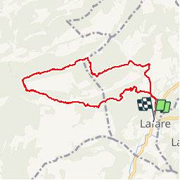
Trail Walking of 9.7 km to be discovered at Provence-Alpes-Côte d'Azur, Vaucluse, Lafare. This trail is proposed by alainbarrot.

Description

Rando avec des passages difficiles et une descente en fin de parcourt sur un sentier de chèvre lol.....Mais superbe vue

Elevation profile

Positioning

Country:
France
Region :
Provence-Alpes-Côte d'Azur
Department/Province :
Vaucluse
Municipality :
Lafare
Location:
Unknown
Start:(UTM)
664040 ; 4890210 (31T) N.

Trails nearby

Trail Walking Gigondas - Dentelles Montmirail   - Gigondas - Photo
Walking
tracegps

Walking

Very difficult
(3)
Gigondas, Provence-Alpes-Côte d'Azur, Vaucluse, France
12.4 km | 22 km-effort
7h 0min
Yes
Trail Walking Lafare - Le tour du Grand Montmirail - Lafare - Photo
Walking
tracegps

Walking

Medium
(3)
Lafare, Provence-Alpes-Côte d'Azur, Vaucluse, France
9.1 km | 13.9 km-effort
2h 30min
Yes
Trail Walking Saint-Hippolyte-le-Graveyron - Le graveron petit circuit  - Photo
Walking
Vero7684

Walking

Easy
(1)
Saint-Hippolyte-le-Graveyron, Provence-Alpes-Côte d'Azur, Vaucluse, France
5.7 km | 8.8 km-effort
2h 5min
Yes
Trail Walking Lafare - Une approche des Dentelles de Montmirail - Photo
Walking
tracegps

Walking

Medium
(2)
Lafare, Provence-Alpes-Côte d'Azur, Vaucluse, France
6.6 km | 11.4 km-effort
3h 0min
Yes
Trail Walking Le Barroux - Les Crêtes du Graveyron par l'écluse de la Falque - Photo
Walking
GUIDE
supercolas

Walking

Difficult
Le Barroux, Provence-Alpes-Côte d'Azur, Vaucluse, France
9 km | 13.4 km-effort
2h 57min
Yes
Trail Walking Gigondas - 84 dentelles montmirail - Photo
Walking
GUIDE
randodyssée

Walking

Difficult
Gigondas, Provence-Alpes-Côte d'Azur, Vaucluse, France
14.6 km | 25 km-effort
8h 18min
Yes
Trail Walking La Roque-Alric - Les 4 sommets de la Roque Alric - Photo
Walking
GUIDE
supercolas

Walking

Medium
La Roque-Alric, Provence-Alpes-Côte d'Azur, Vaucluse, France
10.9 km | 18 km-effort
3h 32min
Yes
Trail Walking La Roque-Alric - Rochers des Évêques  - Photo
Walking
GUIDE
supercolas

Walking

Medium
La Roque-Alric, Provence-Alpes-Côte d'Azur, Vaucluse, France
6.7 km | 11 km-effort
2h 26min
Yes
Trail Walking Gigondas - Gigondas Dentelles Sarasines Grande Montagne  - Photo
Walking
GUIDE
nadinebondoux

Walking

Difficult
(1)
Gigondas, Provence-Alpes-Côte d'Azur, Vaucluse, France
15.4 km | 26 km-effort
5h 57min
Yes


Close
My subscriptions