Trail Walking Antrona Schieranco - Lago Di Antrona - Photo
 i20
i20

User

© OpenStreetMap contributors
Length
Length
3.7 km
Max alt
Max alt
1256 m
Uphill gradient
Uphill gradient
225 m
Km-Effort
Km-Effort  
6.7 km
Min alt
Min alt
1067 m
Downhill gradient
Downhill gradient
225 m
Boucle
Boucle
Yes
Creation date :
2023-07-15 13:52:12.934
Updated on :
2023-07-15 14:55:03.668

(0 Reviews)

Walking
Walking
1h02
Difficulty : Medium

Scan this QR Code to open this trail in the SityTrail application

FREE GPS app for hiking

Logo SityTrail SityTrail

IGN / Geographical institutes

Download SityTrail from the App Store Download SityTrail from Google Play

Logo SityTrail SityTrail World

The world is yours!

Download SityTrail from the App Store Download SityTrail from Google Play Download SityTrail on Huawei AppGallery

About

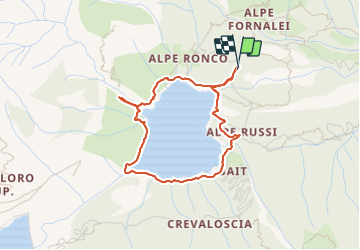
Trail Walking of 3.7 km to be discovered at Piemont, Verbano-Cusio-Ossola, Antrona Schieranco. This trail is proposed by i20.

Elevation profile

Positioning

Country:
Italy
Region :
Piemont
Department/Province :
Verbano-Cusio-Ossola
Municipality :
Antrona Schieranco
Location:
Unknown
Start:(UTM)
430049 ; 5100894 (32T) N.

Trails nearby

Trail On foot Antrona Schieranco - C34 - Lago di Campliccioli - Lago di Camposecco - Photo
On foot
GUIDE+

On foot

Easy
Antrona Schieranco, Piemont, Verbano-Cusio-Ossola, Italy
3.8 km | 13.2 km-effort
2h 59min
No
Trail On foot Antrona Schieranco - C23 - Campliccioli, bivio C00 - Alpe Lombraoro sotto, bivio C00 - Photo
On foot
GUIDE+

On foot

Easy
Antrona Schieranco, Piemont, Verbano-Cusio-Ossola, Italy
9.2 km | 18.7 km-effort
4h 14min
No
Trail On foot Antrona Schieranco - C00 - Strada Antronesca tappa 2 - Photo
On foot
GUIDE+

On foot

Easy
Antrona Schieranco, Piemont, Verbano-Cusio-Ossola, Italy
8.2 km | 18.8 km-effort
4h 16min
No
Trail On foot Antrona Schieranco - (SI E52N) Bivacco Cingino - Rifugio Andolla - Photo
On foot
GUIDE+

On foot

Medium
Antrona Schieranco, Piemont, Verbano-Cusio-Ossola, Italy
11.3 km | 28 km-effort
6h 25min
No
Trail On foot Antrona Schieranco - C00 - Strada Antronesca tappa 3 - Photo
On foot
GUIDE+

On foot

Medium
Antrona Schieranco, Piemont, Verbano-Cusio-Ossola, Italy
13 km | 23 km-effort
5h 11min
No
Trail On foot Antrona Schieranco - C32 - Forcola di Cheggio - Photo
On foot
GUIDE+

On foot

Easy
Antrona Schieranco, Piemont, Verbano-Cusio-Ossola, Italy
5.2 km | 14.8 km-effort
3h 22min
No
Trail On foot Antrona Schieranco - C27 - Antronapiana - Bivio C99 (Coronette) - Photo
On foot
GUIDE+

On foot

Difficult
Antrona Schieranco, Piemont, Verbano-Cusio-Ossola, Italy
13.2 km | 32 km-effort
7h 16min
No
Trail On foot Antrona Schieranco - (SI E56) Rifugio Città di Novara all'Alpe Cheggio - Rifugio Alpe Laghetto - Photo
On foot
GUIDE+

On foot

Medium
Antrona Schieranco, Piemont, Verbano-Cusio-Ossola, Italy
11.7 km | 26 km-effort
5h 52min
No
Trail On foot Antrona Schieranco - (SI E53N) Rifugio Andolla - Rifugio Alpe Laghetto - Photo
On foot
GUIDE+

On foot

Easy
Antrona Schieranco, Piemont, Verbano-Cusio-Ossola, Italy
9.6 km | 18.3 km-effort
4h 10min
No


Close
My subscriptions