Trail Bicycle tourism Győr - vienne Budapest jour 4 - Photo

vienne Budapest jour 4

 marc6262
marc6262

User

© OpenStreetMap contributors
Length
Length
49 km
Max alt
Max alt
130 m
Uphill gradient
Uphill gradient
268 m
Km-Effort
Km-Effort  
52 km
Min alt
Min alt
104 m
Downhill gradient
Downhill gradient
275 m
Boucle
Boucle
No
Creation date :
2023-07-15 05:51:53.309
Updated on :
2023-07-15 13:00:04.131

(0 Reviews)

Bicycle tourism
Bicycle tourism
3h19
Difficulty : Easy

Scan this QR Code to open this trail in the SityTrail application

FREE GPS app for hiking

Logo SityTrail SityTrail

IGN / Geographical institutes

Download SityTrail from the App Store Download SityTrail from Google Play

Logo SityTrail SityTrail World

The world is yours!

Download SityTrail from the App Store Download SityTrail from Google Play Download SityTrail on Huawei AppGallery

About

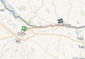
Trail Bicycle tourism of 49 km to be discovered at Transdanubia, Győr-Moson-Sopron, Győr. This trail is proposed by marc6262.

Elevation profile

Positioning

Country:
Hungary
Region :
Transdanubia
Department/Province :
Győr-Moson-Sopron
Municipality :
Győr
Location:
Unknown
Start:(UTM)
697446 ; 5284744 (33T) N.

Trails nearby

Trail On foot Pannonhalma - S+ Pannonhalma - Győrság - Écs v.á. - Photo
On foot
PRO

On foot

Easy
Pannonhalma, Transdanubia, Győr-Moson-Sopron, Hungary
7.5 km | 8.6 km-effort
1h 57min
No
Trail On foot Győrújbarát - K■ Győrújbarát - Photo
On foot
PRO

On foot

Easy
Győrújbarát, Transdanubia, Győr-Moson-Sopron, Hungary
9.7 km | 13.6 km-effort
3h 5min
No
Trail On foot Győrújbarát - Kökényező ösvény - Photo
On foot
PRO

On foot

Easy
Győrújbarát, Transdanubia, Győr-Moson-Sopron, Hungary
4.7 km | 5.8 km-effort
1h 18min
Yes
Trail On foot Győrújbarát - Tobozgyűjtő út - Photo
On foot
PRO

On foot

Easy
Győrújbarát, Transdanubia, Győr-Moson-Sopron, Hungary
5.3 km | 7.9 km-effort
1h 47min
Yes
Trail On foot Écs - P+ Écs v.á. - Photo
On foot
PRO

On foot

Easy
Écs, Transdanubia, Győr-Moson-Sopron, Hungary
4.8 km | 6.6 km-effort
1h 30min
No
Trail On foot Felpéc - S+ Tényő - Felpéc - Photo
On foot
PRO

On foot

Easy
Felpéc, Transdanubia, Győr-Moson-Sopron, Hungary
3.9 km | 5.4 km-effort
1h 14min
No
Trail On foot Tényő - Z+ - Photo
On foot
PRO

On foot

Easy
Tényő, Transdanubia, Győr-Moson-Sopron, Hungary
3 km | 4.1 km-effort
55min
No
Trail On foot Győrújbarát - P+ Győrújbarát- Tényő - Photo
On foot
PRO

On foot

Easy
Győrújbarát, Transdanubia, Győr-Moson-Sopron, Hungary
5.4 km | 7.3 km-effort
1h 40min
No
Trail Bicycle tourism Lipót - Descente Danube - Lipot - Gyor - Photo
Bicycle tourism
s0c7

Bicycle tourism

Very easy
Lipót, Transdanubia, Győr-Moson-Sopron, Hungary
28 km | 29 km-effort
1h 32min
No


Close
My subscriptions