Trail Walking Tournavaux - tournavaux 8,6 km - Photo

tournavaux 8,6 km

 rvapeldo
rvapeldo

User GUIDE

© OpenStreetMap contributors
Length
Length
8.4 km
Max alt
Max alt
329 m
Uphill gradient
Uphill gradient
242 m
Km-Effort
Km-Effort  
11.6 km
Min alt
Min alt
142 m
Downhill gradient
Downhill gradient
240 m
Boucle
Boucle
Yes
Creation date :
2018-10-06 08:30:39.854
Updated on :
2018-10-06 08:30:39.881

(0 Reviews)

Walking
Walking
2h31
Difficulty : Easy

Scan this QR Code to open this trail in the SityTrail application

FREE GPS app for hiking

Logo SityTrail SityTrail

IGN / Geographical institutes

Download SityTrail from the App Store Download SityTrail from Google Play

Logo SityTrail SityTrail World

The world is yours!

Download SityTrail from the App Store Download SityTrail from Google Play Download SityTrail on Huawei AppGallery

About

Trail Walking of 8.4 km to be discovered at Grand Est, Ardennes, Tournavaux. This trail is proposed by rvapeldo.

Description

Tout sur les crêtes de Tournavaux et de Haulmé, sur le point de vue du Liry

Elevation profile

Positioning

Country:
France
Region :
Grand Est
Department/Province :
Ardennes
Municipality :
Tournavaux
Location:
Unknown
Start:(UTM)
628331 ; 5526036 (31U) N.

Trails nearby

Trail Walking Haulmé - Thilay - Haulmé - Navaux - Photo
Walking
tracegps

Walking

Medium
(3)
Haulmé, Grand Est, Ardennes, France
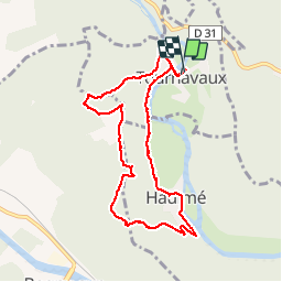
15.3 km | 21 km-effort
3h 15min
Yes
Trail Walking Monthermé - De Monthermé à Bogny sur Meuse par les sentiers de crêtes - Photo
Walking
tracegps

Walking

Difficult
(2)
Monthermé, Grand Est, Ardennes, France
14.6 km | 23 km-effort
5h 0min
Yes
Trail Walking Bogny-sur-Meuse - La promenade du Liry et des Quatre Fils Aymon - Photo
Walking
GUIDE
Desrumaux

Walking

Medium
(1)
Bogny-sur-Meuse, Grand Est, Ardennes, France
11.4 km | 16.9 km-effort
3h 0min
Yes
Trail Walking Les Hautes-Rivières - Hautes Rivières Roches aux Corpias 24,8 - Photo
Walking
GUIDE
rvapeldo

Walking

Difficult
Les Hautes-Rivières, Grand Est, Ardennes, France
25 km | 39 km-effort
8h 34min
Yes
Trail Walking Monthermé - La roche 7H Monthermé  - Photo
Walking
macrid

Walking

Medium
Monthermé, Grand Est, Ardennes, France
5.9 km | 9 km-effort
2h 24min
Yes
Trail Walking Monthermé - les woiries  mercredi  - Photo
Walking
Nicolesophie08

Walking

Medium
Monthermé, Grand Est, Ardennes, France
9.6 km | 12.7 km-effort
3h 37min
No
Trail Walking Les Hautes-Rivières - Hautes Rivières Naux retour 13 Km - Photo
Walking
GUIDE
rvapeldo

Walking

Medium
Les Hautes-Rivières, Grand Est, Ardennes, France
13.7 km | 19.6 km-effort
4h 0min
Yes
Trail Walking Monthermé - Monthermé 22,7 km tour des rochers  - Photo
Walking
GUIDE
rvapeldo

Walking

Difficult
Monthermé, Grand Est, Ardennes, France
23 km | 36 km-effort
8h 20min
Yes
Trail Walking Monthermé - Monthermé - Photo
Walking
mjh

Walking

Medium
Monthermé, Grand Est, Ardennes, France
16 km | 21 km-effort
3h 46min
Yes


Close
My subscriptions