![](/images/other/stat-length.png)
![Trail Bicycle tourism Carantec - kermen à Goulven - Photo](https://media.geolcdn.com/t/1900/400/1b0896a8-9fcc-41e5-a561-8f07dcc5f01b.jpg&format=pjpeg&maxdim=2)
kermen à Goulven
nadd73
User GUIDE
![Length](/images/other/stat-length.png)
Length
53 km
![Max alt](https://static1.geolcdn.com/siteimages/upload/files/1508320355ic_sort_altitude_max_24dp.png)
Max alt
55 m
![Uphill gradient](https://static1.geolcdn.com/siteimages/upload/files/1508320355ic_sort_den_pos_24dp.png)
Uphill gradient
458 m
![Km-Effort](/images/other/stat-length.png)
Km-Effort
59 km
![Min alt](https://static1.geolcdn.com/siteimages/upload/files/1508320355ic_sort_altitude_min_24dp.png)
Min alt
-1 m
![Downhill gradient](https://static1.geolcdn.com/siteimages/upload/files/1508320355ic_sort_den_neg_24dp.png)
Downhill gradient
499 m
![Boucle](https://static1.geolcdn.com/siteimages/upload/files/16400158638029165_repeat_loop_refresh_sync_direction_icon.png)
Boucle
No
Creation date :
2023-07-10 08:00:08.705
Updated on :
2023-07-10 17:33:26.677
![Bicycle tourism](https://static1.geolcdn.com/sitytour/trail-icons/204.png)
4h41
Difficulty : Difficult
![Scan this QR Code to open this trail in the SityTrail application](https://capi.geolives.com/qq0zvz2zws4bq2lad0pu/sitytour/trails/3729501/qr.png?size=200)
FREE GPS app for hiking
About
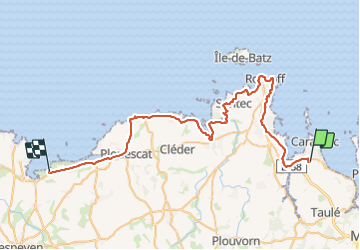
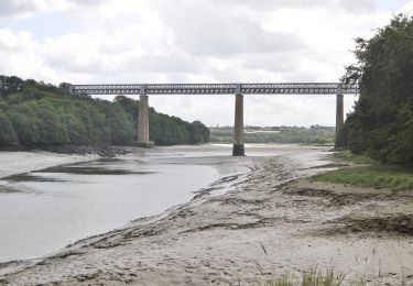
Trail Bicycle tourism of 53 km to be discovered at Brittany, Finistère, Carantec. This trail is proposed by nadd73.
Description
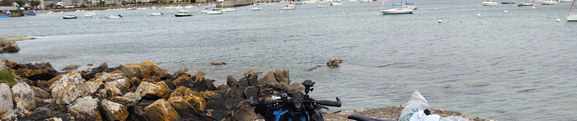
Le vent est très fort et je l'ai de face.
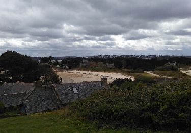
Belles plages de sable blanc.
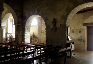
Visite de St pol de Léon et Plouescat
Je mets difficile à cause du vent.
Positioning
Country:
France
Region :
Brittany
Department/Province :
Finistère
Municipality :
Carantec
Location:
Unknown
Start:(Dec)
Start:(UTM)
432194 ; 5388971 (30U) N.
Comments
Trails nearby
![Trail Walking Carantec - N°2 Carantec - Roscoff (30.08.23) - Photo](https://media.geolcdn.com/t/375/260/ext.jpg?maxdim=2&url=https%3A%2F%2Fstatic1.geolcdn.com%2Fsiteimages%2Fupload%2Ffiles%2F1553511878bg_sport_marche.png)
![Walking Walking](https://static1.geolcdn.com/sitytour/trail-icons/101.png)
N°2 Carantec - Roscoff (30.08.23)
Walking
Very difficult
(1)
Carantec,
Brittany,
Finistère,
France
![](/images/other/stat-length.png)
22 km | 25 km-effort
5h 43min
![](https://static1.geolcdn.com/siteimages/upload/files/16400158638029165_repeat_loop_refresh_sync_direction_icon.png)
No
![Trail Other activity Carantec - le frout - ile calot 23,km - Photo](https://media.geolcdn.com/t/375/260/ext.jpg?maxdim=2&url=https%3A%2F%2Fservices.sitytrail.com%2FGeolivesWS%2FDownloadMedia.ashx%3FTrailID%3D558971%26Media%3Dfix__20160425130033.jpg)
![Other activity Other activity](https://static1.geolcdn.com/sitytour/trail-icons/900.png)
le frout - ile calot 23,km
Other activity
Very easy
(2)
Carantec,
Brittany,
Finistère,
France
![](/images/other/stat-length.png)
23 km | 28 km-effort
6h 4min
![](https://static1.geolcdn.com/siteimages/upload/files/16400158638029165_repeat_loop_refresh_sync_direction_icon.png)
Yes
![Trail Walking Carantec - 30.08.23 Carantec -- Roscoff - Photo](https://media.geolcdn.com/t/375/260/a939044f-ea50-435a-ad51-7a43207b839a.jpg&format=jpg&maxdim=2)
![Walking Walking](https://static1.geolcdn.com/sitytour/trail-icons/101.png)
30.08.23 Carantec -- Roscoff
Walking
Very difficult
Carantec,
Brittany,
Finistère,
France
![](/images/other/stat-length.png)
23 km | 26 km-effort
5h 54min
![](https://static1.geolcdn.com/siteimages/upload/files/16400158638029165_repeat_loop_refresh_sync_direction_icon.png)
No
![Trail Walking Plouénan - Bretagne nord J3am - Plouénan - Carantec - Photo](https://media.geolcdn.com/t/375/260/fbfcf502-134b-411d-8e24-e15ad3669ff7.jpg&format=jpg&maxdim=2)
![Walking Walking](https://static1.geolcdn.com/sitytour/trail-icons/101.png)
Bretagne nord J3am - Plouénan - Carantec
Walking
Very easy
Plouénan,
Brittany,
Finistère,
France
![](/images/other/stat-length.png)
9 km | 10.9 km-effort
2h 10min
![](https://static1.geolcdn.com/siteimages/upload/files/16400158638029165_repeat_loop_refresh_sync_direction_icon.png)
No
![Trail Walking Carantec - Autour de Carantec ( GR34) - Photo](https://media.geolcdn.com/t/375/260/ext.jpg?maxdim=2&url=https%3A%2F%2Fservices.sitytrail.com%2FGeolivesWS%2FDownloadMedia.ashx%3FTrailID%3D577566%26Media%3D4ff25c3a-e18b-4096-9c2b-0ffe1f850942.jpg)
![Walking Walking](https://static1.geolcdn.com/sitytour/trail-icons/101.png)
Autour de Carantec ( GR34)
Walking
Easy
Carantec,
Brittany,
Finistère,
France
![](/images/other/stat-length.png)
13.3 km | 15.8 km-effort
4h 14min
![](https://static1.geolcdn.com/siteimages/upload/files/16400158638029165_repeat_loop_refresh_sync_direction_icon.png)
Yes
![Trail Walking Henvic - HENVIC - Photo](https://media.geolcdn.com/t/375/260/7054e9a2-6688-4c1c-aa62-f85e7ae2b1d7.jpg&format=jpg&maxdim=2)
![Walking Walking](https://static1.geolcdn.com/sitytour/trail-icons/101.png)
![Trail Walking Carantec - Tour de l'île Callot - Photo](https://media.geolcdn.com/t/375/260/81a2c851-db0f-4393-b8b8-d71c962b11f2.jpg&format=jpg&maxdim=2)
![Walking Walking](https://static1.geolcdn.com/sitytour/trail-icons/101.png)
Tour de l'île Callot
Walking
Easy
Carantec,
Brittany,
Finistère,
France
![](/images/other/stat-length.png)
9.9 km | 11.4 km-effort
3h 9min
![](https://static1.geolcdn.com/siteimages/upload/files/16400158638029165_repeat_loop_refresh_sync_direction_icon.png)
Yes
![Trail On foot Henvic - Boucle du Vanneg - Photo](https://media.geolcdn.com/t/375/260/f481ee96-ce92-46e0-b4ad-41ed96dba38e.jpeg&format=jpg&maxdim=2)
![On foot On foot](https://static1.geolcdn.com/sitytour/trail-icons/100.png)
Boucle du Vanneg
On foot
Easy
Henvic,
Brittany,
Finistère,
France
![](/images/other/stat-length.png)
9.2 km | 11.4 km-effort
2h 34min
![](https://static1.geolcdn.com/siteimages/upload/files/16400158638029165_repeat_loop_refresh_sync_direction_icon.png)
Yes
![Trail On foot Locquénolé - Circuit du Phare de la Lande - Photo](https://media.geolcdn.com/t/375/260/f1f4f500-15ba-42ad-a100-c3242f454aa5.jpeg&format=jpg&maxdim=2)
![On foot On foot](https://static1.geolcdn.com/sitytour/trail-icons/100.png)
Circuit du Phare de la Lande
On foot
Easy
Locquénolé,
Brittany,
Finistère,
France
![](/images/other/stat-length.png)
7.9 km | 10.1 km-effort
2h 17min
![](https://static1.geolcdn.com/siteimages/upload/files/16400158638029165_repeat_loop_refresh_sync_direction_icon.png)
Yes