![](/images/other/stat-length.png)
![Trail Walking Saint-Paul-sur-Ubaye - lac des neuf couleurs - Photo](https://media.geolcdn.com/t/1900/400/42d8d111-cdeb-47c8-a88d-bbc43b7643b5.jpg&format=pjpeg&maxdim=2)
lac des neuf couleurs
GuyVachet
User
![Length](/images/other/stat-length.png)
![Max alt](https://static1.geolcdn.com/siteimages/upload/files/1508320355ic_sort_altitude_max_24dp.png)
![Uphill gradient](https://static1.geolcdn.com/siteimages/upload/files/1508320355ic_sort_den_pos_24dp.png)
![Km-Effort](/images/other/stat-length.png)
![Min alt](https://static1.geolcdn.com/siteimages/upload/files/1508320355ic_sort_altitude_min_24dp.png)
![Downhill gradient](https://static1.geolcdn.com/siteimages/upload/files/1508320355ic_sort_den_neg_24dp.png)
![Boucle](https://static1.geolcdn.com/siteimages/upload/files/16400158638029165_repeat_loop_refresh_sync_direction_icon.png)
![Walking](https://static1.geolcdn.com/sitytour/trail-icons/101.png)
7h04
Difficulty : Very difficult
![Scan this QR Code to open this trail in the SityTrail application](https://capi.geolives.com/qq0zvz2zws4bq2lad0pu/sitytour/trails/3728362/qr.png?size=200)
FREE GPS app for hiking
About
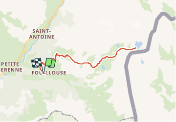
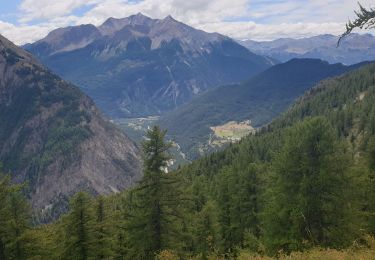
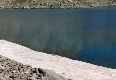
Trail Walking of 18.9 km to be discovered at Provence-Alpes-Côte d'Azur, Alpes-de-Haute-Provence, Saint-Paul-sur-Ubaye. This trail is proposed by GuyVachet.
Description
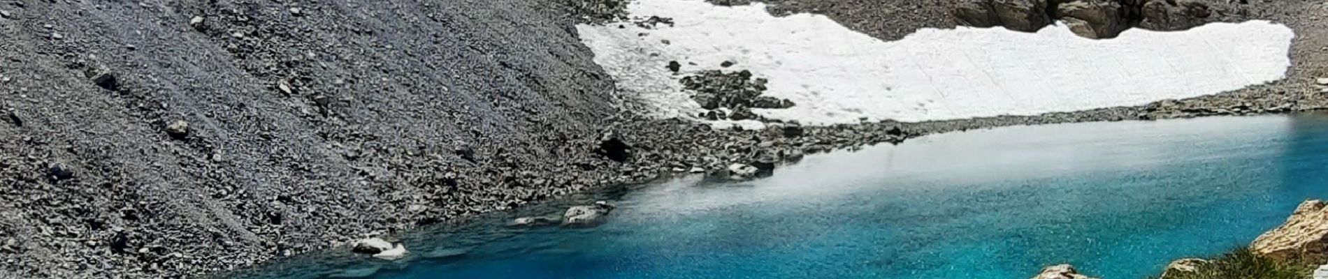
Rando en Aller/Retour à partir de Fouillouse pour atteindre le lac des neuf couleurs qui se mérite et aussi quelques autres au-delà du refuge de Chambeyron, entre l'Aiguille et le Brec du même nom. La montée est heureusement très régulière en commençant tranquillement jusqu'aux Vistes puis la pente s'installe en forêt jusqu'au Carrefour des Cloutasses, forêt que l'on quitte progressivement pour profiter de la magnifique diversité des fleurs et aussi des marmottes. Une halte au refuge est bienvenue, ne serait-ce que pour reprendre de l'eau (ou un café pourquoi pas) avant de poursuivre pour découvrir les lacs jusqu'à celui des 9 couleurs. Il est difficile de les comparer mais le Lac Long est remarquable avant d'atteindre celui qui constitue le clou de la randonnée et où la frontière italienne est à portée de main via le Col de Gypière. La descente emprunte le même itinéraire.
Positioning
Comments
Trails nearby
![Trail Walking Saint-Paul-sur-Ubaye - SAINT PAUL . Fouillouse o - Photo](https://media.geolcdn.com/t/375/260/01b97f27-72a2-48c1-94e8-20c6a12c365d.jpg&format=jpg&maxdim=2)
![Walking Walking](https://static1.geolcdn.com/sitytour/trail-icons/101.png)
Walking
![](/images/other/stat-length.png)
![](https://static1.geolcdn.com/siteimages/upload/files/16400158638029165_repeat_loop_refresh_sync_direction_icon.png)
![Trail Walking Saint-Paul-sur-Ubaye - Pic Panestrel - Photo](https://media.geolcdn.com/t/375/260/ext.jpg?maxdim=2&url=https%3A%2F%2Fstatic1.geolcdn.com%2Fsiteimages%2Fupload%2Ffiles%2F1553511878bg_sport_marche.png)
![Walking Walking](https://static1.geolcdn.com/sitytour/trail-icons/101.png)
Walking
![](/images/other/stat-length.png)
![](https://static1.geolcdn.com/siteimages/upload/files/16400158638029165_repeat_loop_refresh_sync_direction_icon.png)
![Trail Other activity Saint-Paul-sur-Ubaye - massour - Photo](https://media.geolcdn.com/t/375/260/ext.jpg?maxdim=2&url=https%3A%2F%2Fstatic1.geolcdn.com%2Fsiteimages%2Fupload%2Ffiles%2F1545311037marcheuse_200dpi.jpg)
![Other activity Other activity](https://static1.geolcdn.com/sitytour/trail-icons/900.png)
Other activity
![](/images/other/stat-length.png)
![](https://static1.geolcdn.com/siteimages/upload/files/16400158638029165_repeat_loop_refresh_sync_direction_icon.png)
![Trail Walking Saint-Paul-sur-Ubaye - Lac des 9 couleurs - Photo](https://media.geolcdn.com/t/375/260/ext.jpg?maxdim=2&url=https%3A%2F%2Fstatic1.geolcdn.com%2Fsiteimages%2Fupload%2Ffiles%2F1553511878bg_sport_marche.png)
![Walking Walking](https://static1.geolcdn.com/sitytour/trail-icons/101.png)
Walking
![](/images/other/stat-length.png)
![](https://static1.geolcdn.com/siteimages/upload/files/16400158638029165_repeat_loop_refresh_sync_direction_icon.png)
![Trail Walking Saint-Paul-sur-Ubaye - Col des Houerts - Photo](https://media.geolcdn.com/t/375/260/e589d054-4f9a-4316-9b77-f2f1a1c65f56.jpg&format=jpg&maxdim=2)
![Walking Walking](https://static1.geolcdn.com/sitytour/trail-icons/101.png)
Walking
![](/images/other/stat-length.png)
![](https://static1.geolcdn.com/siteimages/upload/files/16400158638029165_repeat_loop_refresh_sync_direction_icon.png)
![Trail Walking Val-d'Oronaye - FORT DE ST-OURS HAUT - Photo](https://media.geolcdn.com/t/375/260/2761062a-5cf2-4907-8838-1cdfd32b0b4f.jpg&format=jpg&maxdim=2)
![Walking Walking](https://static1.geolcdn.com/sitytour/trail-icons/101.png)
Walking
![](/images/other/stat-length.png)
![](https://static1.geolcdn.com/siteimages/upload/files/16400158638029165_repeat_loop_refresh_sync_direction_icon.png)
![Trail Touring skiing Saint-Paul-sur-Ubaye - tour du breck de Chambeyron - Photo](https://media.geolcdn.com/t/375/260/f8df1b9b-c618-4fb1-a2a1-0cbef9a93db1.jpg&format=jpg&maxdim=2)
![Touring skiing Touring skiing](https://static1.geolcdn.com/sitytour/trail-icons/503.png)
Touring skiing
![](/images/other/stat-length.png)
![](https://static1.geolcdn.com/siteimages/upload/files/16400158638029165_repeat_loop_refresh_sync_direction_icon.png)
![Trail Walking Saint-Paul-sur-Ubaye - Ancienne Batterie de Vallon Claous - Photo](https://media.geolcdn.com/t/375/260/4cf3070c-6efe-42b2-b373-f9134ec46e4e.jpg&format=jpg&maxdim=2)
![Walking Walking](https://static1.geolcdn.com/sitytour/trail-icons/101.png)
Walking
![](/images/other/stat-length.png)
![](https://static1.geolcdn.com/siteimages/upload/files/16400158638029165_repeat_loop_refresh_sync_direction_icon.png)
![Trail Walking Saint-Paul-sur-Ubaye - pic de la Fema par le lac des 9 couleurs - Photo](https://media.geolcdn.com/t/375/260/5cbb024d-f3ce-4de7-b2f6-e2e7bc05dc82.jpg&format=jpg&maxdim=2)
![Walking Walking](https://static1.geolcdn.com/sitytour/trail-icons/101.png)
Walking
![](/images/other/stat-length.png)
![](https://static1.geolcdn.com/siteimages/upload/files/16400158638029165_repeat_loop_refresh_sync_direction_icon.png)