Trail Walking Saint-Aventin - Pic du Céciré = tentative - Photo

Pic du Céciré = tentative

 chrisgps
chrisgps

User

© OpenStreetMap contributors
Length
Length
12.5 km
Max alt
Max alt
2280 m
Uphill gradient
Uphill gradient
821 m
Km-Effort
Km-Effort  
23 km
Min alt
Min alt
1700 m
Downhill gradient
Downhill gradient
821 m
Boucle
Boucle
Yes
Creation date :
2023-06-29 06:58:02.522
Updated on :
2023-07-26 18:19:58.277

(0 Reviews)

Walking
Walking
5h19
Difficulty : Medium

Scan this QR Code to open this trail in the SityTrail application

FREE GPS app for hiking

Logo SityTrail SityTrail

IGN / Geographical institutes

Download SityTrail from the App Store Download SityTrail from Google Play

Logo SityTrail SityTrail World

The world is yours!

Download SityTrail from the App Store Download SityTrail from Google Play Download SityTrail on Huawei AppGallery

About

Trail Walking of 12.5 km to be discovered at Occitania, Haute-Garonne, Saint-Aventin. This trail is proposed by chrisgps.

Description

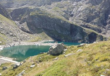
en suivant le GR10 comme conseillé, le départ sur le plateau de Superbagnère est à 1831m et il faut "descendre" jusqu'au ruisseau de Betet à 1770 et remonter jusqu'à la Coume de Bourg à 2272m. Là on a déjà fait 820m.
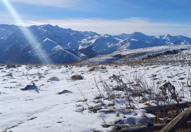
Pour arriver au Céciré ça fera 950m environ, contre 560m par l'ancienne trace du GR10 !
En plus la brume montait. On le refera !

Elevation profile

Positioning

Country:
France
Region :
Occitania
Department/Province :
Haute-Garonne
Municipality :
Saint-Aventin
Location:
Unknown
Start:(UTM)
301702 ; 4737765 (31T) N.

Trails nearby

Trail Snowshoes Juzet-de-Luchon - JUZET - PAS DE LA COMBE (LABACH) - Photo
Snowshoes
Marcocroco

Snowshoes

Medium
(1)
Juzet-de-Luchon, Occitania, Haute-Garonne, France
7.1 km | 12.5 km-effort
2h 33min
Yes
Trail Walking Saint-Mamet - Fonds de Burbe - Saint Mamet - Photo
Walking
tracegps

Walking

Difficult
(1)
Saint-Mamet, Occitania, Haute-Garonne, France
15.6 km | 27 km-effort
4h 0min
Yes
Trail Mountain bike Saint-Aventin - Luchon Kbour - Photo
Mountain bike
tracegps

Mountain bike

Very difficult
(1)
Saint-Aventin, Occitania, Haute-Garonne, France
11 km | 16.7 km-effort
1h 0min
No
Trail On foot Castillon-de-Larboust - Lac Vert, Boucle par l'Est - Photo
On foot
GUIDE+

On foot

Easy
Castillon-de-Larboust, Occitania, Haute-Garonne, France
8.8 km | 19.5 km-effort
4h 26min
No
Trail Walking Bagnères-de-Luchon - GR 10 - 3 - Photo
Walking
loic09

Walking

Medium
(2)
Bagnères-de-Luchon, Occitania, Haute-Garonne, France
250 km | 489 km-effort
89h 8min
No
Trail Walking Castillon-de-Larboust - lac Charles, lac bleu, lac vert vallée du Lys  - Photo
Walking
GUIDE
lhomme.ph

Walking

Difficult
Castillon-de-Larboust, Occitania, Haute-Garonne, France
15.1 km | 32 km-effort
11h 17min
Yes
Trail Walking Sode - cabane de Plan Pouné, par refuge de Cualot - Photo
Walking
chrisgps

Walking

Very difficult
Sode, Occitania, Haute-Garonne, France
9.8 km | 19.5 km-effort
4h 26min
Yes
Trail Walking Saint-Aventin - Cabane de Courreau en boucle depuis St Aventin  - Photo
Walking
GUIDE
lhomme.ph

Walking

Medium
Saint-Aventin, Occitania, Haute-Garonne, France
13.3 km | 24 km-effort
6h 10min
Yes
Trail Walking Castillon-de-Larboust - Cabane de la Coume - Photo
Walking
swp648

Walking

Difficult
Castillon-de-Larboust, Occitania, Haute-Garonne, France
9.1 km | 18.4 km-effort
3h 39min
Yes


Close
My subscriptions