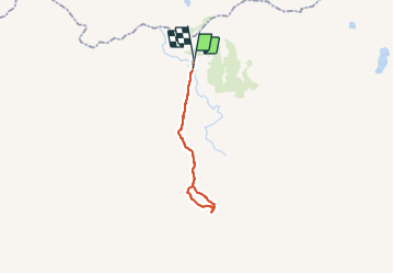
Trail Trail Unknown - kerlingarfjoll - Photo
© OpenStreetMap contributors
Length
Length
11.2 km
Max alt
Max alt
0 m
Uphill gradient
Uphill gradient
0 m
Km-Effort
Km-Effort  
11.2 km
Min alt
Min alt
0 m
Downhill gradient
Downhill gradient
0 m
Boucle
Boucle
No
Creation date :
2023-07-08 14:30:19.691
Updated on :
2023-07-08 17:50:15.45

(0 Reviews)

Trail
Trail
3h18
Difficulty : Medium

Scan this QR Code to open this trail in the SityTrail application

FREE GPS app for hiking

Logo SityTrail SityTrail

IGN / Geographical institutes

Download SityTrail from the App Store Download SityTrail from Google Play

Logo SityTrail SityTrail World

The world is yours!

Download SityTrail from the App Store Download SityTrail from Google Play Download SityTrail on Huawei AppGallery

About

Trail Trail of 11.2 km to be discovered at Unknown, Hrunamannahreppur. This trail is proposed by MartineLeermakers.

Description

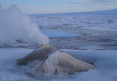
trail van base camp naar geothermisch gebied

Elevation profile

Positioning

Country:
Iceland
Region :
Unknown
Department/Province :
Hrunamannahreppur
Municipality :
Unknown
Location:
Unknown
Start:(UTM)
581057 ; 7174026 (27W) N.

Trails nearby

Trail On foot  - Kjalvegur - Photo
On foot
GUIDE+

On foot

Very easy
, Unknown, Bláskógabyggð, Iceland
21 km | 0 m-effort
Unknown
No


Close
My subscriptions