Trail Walking Manneville-la-Pipard - mannblangy30062023 - Photo
© OpenStreetMap contributors
Length
Length
16.3 km
Max alt
Max alt
135 m
Uphill gradient
Uphill gradient
311 m
Km-Effort
Km-Effort  
20 km
Min alt
Min alt
29 m
Downhill gradient
Downhill gradient
311 m
Boucle
Boucle
Yes
Creation date :
2023-06-30 11:52:38.371
Updated on :
2024-06-15 07:48:16.468

(1 Reviews)

Walking
Walking
4h39
Difficulty : Very difficult

Scan this QR Code to open this trail in the SityTrail application

FREE GPS app for hiking

Logo SityTrail SityTrail

IGN / Geographical institutes

Download SityTrail from the App Store Download SityTrail from Google Play

Logo SityTrail SityTrail World

The world is yours!

Download SityTrail from the App Store Download SityTrail from Google Play Download SityTrail on Huawei AppGallery

About

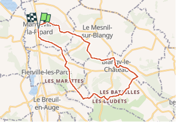
Trail Walking of 16.3 km to be discovered at Normandy, Calvados, Manneville-la-Pipard. This trail is proposed by Gaspard14.

Elevation profile

Positioning

Country:
France
Region :
Normandy
Department/Province :
Calvados
Municipality :
Manneville-la-Pipard
Location:
Unknown
Start:(UTM)
297765 ; 5460292 (31U) N.

Comments

Please log in to post a review or rate the element


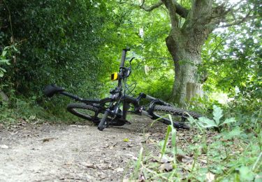
Départ très compliqué végétation envahissante et beaucoup de cailloux


Trails nearby

Trail Walking Pont-l'Évêque - Lac de Pont l'Évêque  - Photo
Walking
tracegps

Walking

Difficult
(3)
Pont-l'Évêque, Normandy, Calvados, France
14.8 km | 18.9 km-effort
4h 10min
Yes
Trail Walking Saint-Hymer - St Hymer - Photo
Walking
Eve - Line

Walking

Medium
Saint-Hymer, Normandy, Calvados, France
12.6 km | 15.3 km-effort
2h 49min
Yes
Trail Walking Pierrefitte-en-Auge - Pierrefitte-en-Auge - Photo
Walking
gr1346

Walking

Medium
(1)
Pierrefitte-en-Auge, Normandy, Calvados, France
15 km | 18.6 km-effort
4h 3min
Yes
Trail Walking Le Torquesne - Le Torquesne - Photo
Walking
tracegps

Walking

Difficult
Le Torquesne, Normandy, Calvados, France
14.9 km | 17.8 km-effort
3h 10min
Yes
Trail Mountain bike Pont-l'Évêque - Rando Pont l'Evèque - Photo
Mountain bike
tracegps

Mountain bike

Difficult
Pont-l'Évêque, Normandy, Calvados, France
32 km | 39 km-effort
2h 30min
Yes
Trail Walking Pont-l'Évêque - Rando Pont l'Evèque - Photo
Walking
tracegps

Walking

Difficult
Pont-l'Évêque, Normandy, Calvados, France
32 km | 39 km-effort
6h 0min
Yes
Trail Mountain bike Pont-l'Évêque - 32 km VTT avec Denys  - Photo
Mountain bike
Marc Girard

Mountain bike

Pont-l'Évêque, Normandy, Calvados, France
32 km | 38 km-effort
2h 55min
No
Trail Mountain bike Saint-Hymer - De Saint - Hymer à Clarbec - Photo
Mountain bike
tracegps

Mountain bike

Difficult
Saint-Hymer, Normandy, Calvados, France
34 km | 41 km-effort
2h 30min
Yes
Trail Mountain bike Saint-Julien-sur-Calonne - De St Julien sur Calonne à Fierville les Parcs - Photo
Mountain bike
tracegps

Mountain bike

Difficult
Saint-Julien-sur-Calonne, Normandy, Calvados, France
23 km | 28 km-effort
2h 0min
Yes


Close
My subscriptions