![](/images/other/stat-length.png)
![Trail Walking Clervaux - 2023-07-03_16h50m23_autopedestres-clervaux - Photo](https://media.geolcdn.com/t/1900/400/ext.pjpeg?maxdim=2&url=https%3A%2F%2Fstatic1.geolcdn.com%2Fsiteimages%2Fupload%2Ffiles%2F1553511878bg_sport_marche.png)
2023-07-03_16h50m23_autopedestres-clervaux
mumu.larandonneuse
User GUIDE
![Length](/images/other/stat-length.png)
![Max alt](https://static1.geolcdn.com/siteimages/upload/files/1508320355ic_sort_altitude_max_24dp.png)
![Uphill gradient](https://static1.geolcdn.com/siteimages/upload/files/1508320355ic_sort_den_pos_24dp.png)
![Km-Effort](/images/other/stat-length.png)
![Min alt](https://static1.geolcdn.com/siteimages/upload/files/1508320355ic_sort_altitude_min_24dp.png)
![Downhill gradient](https://static1.geolcdn.com/siteimages/upload/files/1508320355ic_sort_den_neg_24dp.png)
![Boucle](https://static1.geolcdn.com/siteimages/upload/files/16400158638029165_repeat_loop_refresh_sync_direction_icon.png)
![Walking](https://static1.geolcdn.com/sitytour/trail-icons/101.png)
2h28
Difficulty : Medium
![Scan this QR Code to open this trail in the SityTrail application](https://capi.geolives.com/qq0zvz2zws4bq2lad0pu/sitytour/trails/3721369/qr.png?size=200)
FREE GPS app for hiking
About
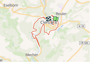
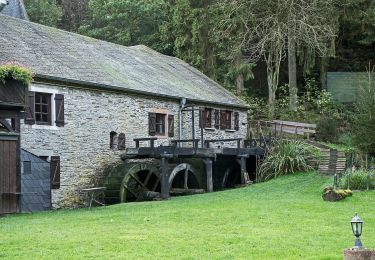
Trail Walking of 7.5 km to be discovered at Unknown, Canton Clervaux, Clervaux. This trail is proposed by mumu.larandonneuse.
Description
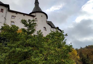
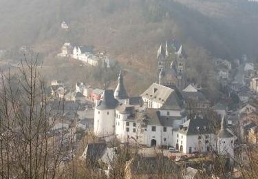
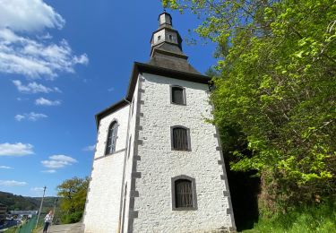
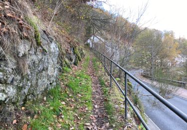
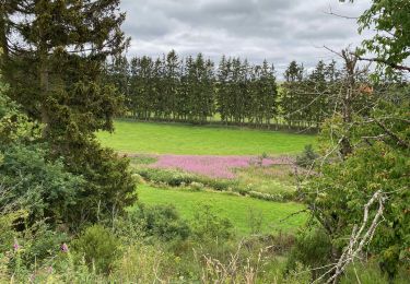
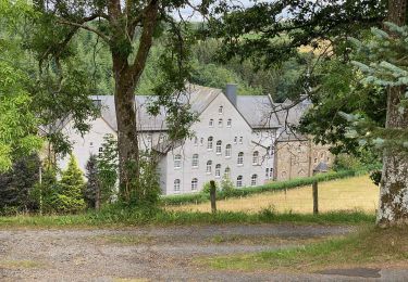
Il s'agit de la randonnée à faire lors de votre séjour à Clervaux. La longueur est accessible à tous bien que les dénivellés sont importants (comme toujours à Clervaux). Vous commencerez par grimper l'ancien parc à gibier pour rejoindre Reuler et découvrir quelques panoramas sur la cité. Ensuite, ce sont les paysages de campagnes qui s'offrent à vous et des points de vue sur l'Abbaye. Ensuite, la forêt prend le dessus jusque l'Abbaye.
ℹ️ www.visit-clervaux.lu
Positioning
Comments
Trails nearby
![Trail Walking Clervaux - 2023-09-06_11h37m03_sentier-local-cl-5 - Photo](https://media.geolcdn.com/t/375/260/4d9c17af-90bd-4623-96d9-f2a288b490ef.jpg&format=jpg&maxdim=2)
![Walking Walking](https://static1.geolcdn.com/sitytour/trail-icons/101.png)
Walking
![](/images/other/stat-length.png)
![](https://static1.geolcdn.com/siteimages/upload/files/16400158638029165_repeat_loop_refresh_sync_direction_icon.png)
![Trail Walking Clervaux - 2023-09-06_11h14m49_sentier-local-cl-2 - Photo](https://media.geolcdn.com/t/375/260/378df12a-c7ca-4826-9832-7c942624e739.jpg&format=jpg&maxdim=2)
![Walking Walking](https://static1.geolcdn.com/sitytour/trail-icons/101.png)
Walking
![](/images/other/stat-length.png)
![](https://static1.geolcdn.com/siteimages/upload/files/16400158638029165_repeat_loop_refresh_sync_direction_icon.png)
![Trail Walking Clervaux - Eislek Pad Clervaux - Photo](https://media.geolcdn.com/t/375/260/a09f0ff8-a7ec-4176-a920-c74694117be0.jpg&format=jpg&maxdim=2)
![Walking Walking](https://static1.geolcdn.com/sitytour/trail-icons/101.png)
Walking
![](/images/other/stat-length.png)
![](https://static1.geolcdn.com/siteimages/upload/files/16400158638029165_repeat_loop_refresh_sync_direction_icon.png)
![Trail Walking Clervaux - Boucle Les paysages cachés - Tronçon 4 - Clervaux - Kautenbach - Photo](https://media.geolcdn.com/t/375/260/ext.jpg?maxdim=2&url=https%3A%2F%2Fservices.sitytrail.com%2FGeolivesWS%2FDownloadMedia.ashx%3FTrailID%3D186890%26Media%3D90f81d4e-606b-4dcc-b8fd-d174effe43fc.jpg)
![Walking Walking](https://static1.geolcdn.com/sitytour/trail-icons/101.png)
Walking
![](/images/other/stat-length.png)
![](https://static1.geolcdn.com/siteimages/upload/files/16400158638029165_repeat_loop_refresh_sync_direction_icon.png)
![Trail Walking Clervaux - LW_CL_2 - Photo](https://media.geolcdn.com/t/375/260/bb422fcb-3477-43d2-8ac8-41400bf08bbc.jpeg&format=jpg&maxdim=2)
![Walking Walking](https://static1.geolcdn.com/sitytour/trail-icons/101.png)
Walking
![](/images/other/stat-length.png)
![](https://static1.geolcdn.com/siteimages/upload/files/16400158638029165_repeat_loop_refresh_sync_direction_icon.png)
![Trail Walking Clervaux - Clervaux Abbaye et Mecher 10 km boucle - Photo](https://media.geolcdn.com/t/375/260/511fe587-f595-4c49-b220-32b06facd07f.jpg&format=jpg&maxdim=2)
![Walking Walking](https://static1.geolcdn.com/sitytour/trail-icons/101.png)
Walking
![](/images/other/stat-length.png)
![](https://static1.geolcdn.com/siteimages/upload/files/16400158638029165_repeat_loop_refresh_sync_direction_icon.png)
![Trail Walking Wincrange - Escapardenne Eisleck Trail: Moulin d'Asselborn - Houffalize - Photo](https://media.geolcdn.com/t/375/260/92df795c-9ebe-4619-8d75-350f07c2d083.jpeg&format=jpg&maxdim=2)
![Walking Walking](https://static1.geolcdn.com/sitytour/trail-icons/101.png)
Walking
![](/images/other/stat-length.png)
![](https://static1.geolcdn.com/siteimages/upload/files/16400158638029165_repeat_loop_refresh_sync_direction_icon.png)
![Trail Walking Clervaux - Escapardenne Eisleck Trail: Clervaux - Moulin d'Asselborn - Photo](https://media.geolcdn.com/t/375/260/46bbdc45-c1ec-447d-9c74-92fb6110c2e6.jpeg&format=jpg&maxdim=2)
![Walking Walking](https://static1.geolcdn.com/sitytour/trail-icons/101.png)
Walking
![](/images/other/stat-length.png)
![](https://static1.geolcdn.com/siteimages/upload/files/16400158638029165_repeat_loop_refresh_sync_direction_icon.png)
![Trail On foot Wincrange - Auto Pedestre Boxhorn - Photo](https://media.geolcdn.com/t/375/260/6e89663e-cdc4-4290-9137-b9abc28300a9.jpeg&format=jpg&maxdim=2)
![On foot On foot](https://static1.geolcdn.com/sitytour/trail-icons/100.png)
On foot
![](/images/other/stat-length.png)
![](https://static1.geolcdn.com/siteimages/upload/files/16400158638029165_repeat_loop_refresh_sync_direction_icon.png)