![](/images/other/stat-length.png)
![Trail Walking Saint-Gildas-de-Rhuys - St Gildas de Rhuys: Le Grand Mont (officiel) - Photo](https://media.geolcdn.com/t/1900/400/ext.pjpeg?maxdim=2&url=https%3A%2F%2Fstatic1.geolcdn.com%2Fsiteimages%2Fupload%2Ffiles%2F1553511878bg_sport_marche.png)
St Gildas de Rhuys: Le Grand Mont (officiel)
dufland
User
![Length](/images/other/stat-length.png)
Length
9.4 km
![Max alt](https://static1.geolcdn.com/siteimages/upload/files/1508320355ic_sort_altitude_max_24dp.png)
Max alt
42 m
![Uphill gradient](https://static1.geolcdn.com/siteimages/upload/files/1508320355ic_sort_den_pos_24dp.png)
Uphill gradient
80 m
![Km-Effort](/images/other/stat-length.png)
Km-Effort
10.4 km
![Min alt](https://static1.geolcdn.com/siteimages/upload/files/1508320355ic_sort_altitude_min_24dp.png)
Min alt
-1 m
![Downhill gradient](https://static1.geolcdn.com/siteimages/upload/files/1508320355ic_sort_den_neg_24dp.png)
Downhill gradient
81 m
![Boucle](https://static1.geolcdn.com/siteimages/upload/files/16400158638029165_repeat_loop_refresh_sync_direction_icon.png)
Boucle
Yes
Creation date :
2023-07-03 14:30:43.515
Updated on :
2023-08-23 14:41:53.387
![Walking](https://static1.geolcdn.com/sitytour/trail-icons/101.png)
2h22
Difficulty : Medium
![Scan this QR Code to open this trail in the SityTrail application](https://capi.geolives.com/qq0zvz2zws4bq2lad0pu/sitytour/trails/3721331/qr.png?size=200)
FREE GPS app for hiking
About
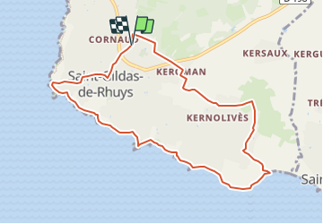
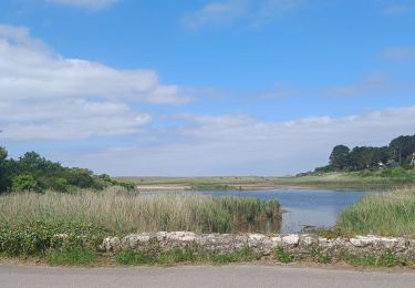
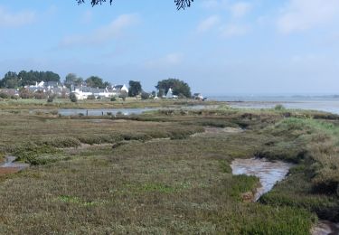
Trail Walking of 9.4 km to be discovered at Brittany, Morbihan, Saint-Gildas-de-Rhuys. This trail is proposed by dufland.
Description
Retrouvez ce circuit dans le Topoguide de Randonnée de la Presqu'ïle de Rhuys disponible dans les offices de tourisme de Sarzeau, Arzon, Saint Gildas et St Colombier. (18 circuits)http://www.rhuys.com/balades-rando-golfe-du-morbihan.php
Positioning
Country:
France
Region :
Brittany
Department/Province :
Morbihan
Municipality :
Saint-Gildas-de-Rhuys
Location:
Unknown
Start:(Dec)
Start:(UTM)
512408 ; 5261337 (30T) N.
Comments
Trails nearby
![Trail Walking Arzon - tour d'Arzon - Photo](https://media.geolcdn.com/t/375/260/8d2666dc-76b6-4531-82fb-267206fdbff7.jpg&format=jpg&maxdim=2)
![Walking Walking](https://static1.geolcdn.com/sitytour/trail-icons/101.png)
tour d'Arzon
Walking
Easy
(1)
Arzon,
Brittany,
Morbihan,
France
![](/images/other/stat-length.png)
12.6 km | 14.1 km-effort
3h 19min
![](https://static1.geolcdn.com/siteimages/upload/files/16400158638029165_repeat_loop_refresh_sync_direction_icon.png)
Yes
![Trail Walking Arzon - Tour du Golfe du Morbihan - 01 - Arzon - Photo](https://media.geolcdn.com/t/375/260/ext.jpg?maxdim=2&url=https%3A%2F%2Fservices.sitytrail.com%2FGeolivesWS%2FDownloadMedia.ashx%3FTrailID%3D109031%26Media%3D2997_2.jpg)
![Walking Walking](https://static1.geolcdn.com/sitytour/trail-icons/101.png)
Tour du Golfe du Morbihan - 01 - Arzon
Walking
Medium
(1)
Arzon,
Brittany,
Morbihan,
France
![](/images/other/stat-length.png)
18.9 km | 21 km-effort
4h 0min
![](https://static1.geolcdn.com/siteimages/upload/files/16400158638029165_repeat_loop_refresh_sync_direction_icon.png)
No
![Trail Walking Arzon - Tour du Golfe - Arzon - Photo](https://media.geolcdn.com/t/375/260/ext.jpg?maxdim=2&url=https%3A%2F%2Fservices.sitytrail.com%2FGeolivesWS%2FDownloadMedia.ashx%3FTrailID%3D107071%26Media%3D11890_2.jpg)
![Walking Walking](https://static1.geolcdn.com/sitytour/trail-icons/101.png)
Tour du Golfe - Arzon
Walking
Medium
(1)
Arzon,
Brittany,
Morbihan,
France
![](/images/other/stat-length.png)
18.2 km | 20 km-effort
4h 30min
![](https://static1.geolcdn.com/siteimages/upload/files/16400158638029165_repeat_loop_refresh_sync_direction_icon.png)
Yes
![Trail Walking Sarzeau - Sarzeau Saint Jacques - Saint Gildas de Rhuys - Photo](https://media.geolcdn.com/t/375/260/ext.jpg?maxdim=2&url=https%3A%2F%2Fstatic1.geolcdn.com%2Fsiteimages%2Fupload%2Ffiles%2F1553511878bg_sport_marche.png)
![Walking Walking](https://static1.geolcdn.com/sitytour/trail-icons/101.png)
Sarzeau Saint Jacques - Saint Gildas de Rhuys
Walking
Easy
(1)
Sarzeau,
Brittany,
Morbihan,
France
![](/images/other/stat-length.png)
14.9 km | 16.4 km-effort
3h 38min
![](https://static1.geolcdn.com/siteimages/upload/files/16400158638029165_repeat_loop_refresh_sync_direction_icon.png)
Yes
![Trail Walking Sarzeau - Pointes de Bernon et de l'Ours - Photo](https://media.geolcdn.com/t/375/260/ext.jpg?maxdim=2&url=https%3A%2F%2Fstatic1.geolcdn.com%2Fsiteimages%2Fupload%2Ffiles%2F1553511878bg_sport_marche.png)
![Walking Walking](https://static1.geolcdn.com/sitytour/trail-icons/101.png)
Pointes de Bernon et de l'Ours
Walking
Medium
(2)
Sarzeau,
Brittany,
Morbihan,
France
![](/images/other/stat-length.png)
9.6 km | 10.8 km-effort
2h 22min
![](https://static1.geolcdn.com/siteimages/upload/files/16400158638029165_repeat_loop_refresh_sync_direction_icon.png)
Yes
![Trail Walking Sarzeau - Circuit du Château de Truscat - Photo](https://media.geolcdn.com/t/375/260/ext.jpg?maxdim=2&url=https%3A%2F%2Fstatic1.geolcdn.com%2Fsiteimages%2Fupload%2Ffiles%2F1553511878bg_sport_marche.png)
![Walking Walking](https://static1.geolcdn.com/sitytour/trail-icons/101.png)
Circuit du Château de Truscat
Walking
Easy
(1)
Sarzeau,
Brittany,
Morbihan,
France
![](/images/other/stat-length.png)
7.4 km | 8.2 km-effort
1h 50min
![](https://static1.geolcdn.com/siteimages/upload/files/16400158638029165_repeat_loop_refresh_sync_direction_icon.png)
Yes
![Trail Other activity Saint-Gildas-de-Rhuys - Houat 1 - Photo](https://media.geolcdn.com/t/375/260/ext.jpg?maxdim=2&url=https%3A%2F%2Fstatic1.geolcdn.com%2Fsiteimages%2Fupload%2Ffiles%2F1545311037marcheuse_200dpi.jpg)
![Other activity Other activity](https://static1.geolcdn.com/sitytour/trail-icons/900.png)
Houat 1
Other activity
Very easy
(1)
Saint-Gildas-de-Rhuys,
Brittany,
Morbihan,
France
![](/images/other/stat-length.png)
18.2 km | 18.7 km-effort
4h 15min
![](https://static1.geolcdn.com/siteimages/upload/files/16400158638029165_repeat_loop_refresh_sync_direction_icon.png)
No
![Trail Walking Saint-Gildas-de-Rhuys - PR_56_St-Gildas-Rhuys_BA_02_Circuit1b_Les-Etangs_20240602 - Photo](https://media.geolcdn.com/t/375/260/c32a814c-43f5-42d3-9319-bc45835ee10e.jpg&format=jpg&maxdim=2)
![Walking Walking](https://static1.geolcdn.com/sitytour/trail-icons/101.png)
PR_56_St-Gildas-Rhuys_BA_02_Circuit1b_Les-Etangs_20240602
Walking
Very easy
Saint-Gildas-de-Rhuys,
Brittany,
Morbihan,
France
![](/images/other/stat-length.png)
12.9 km | 14.3 km-effort
3h 14min
![](https://static1.geolcdn.com/siteimages/upload/files/16400158638029165_repeat_loop_refresh_sync_direction_icon.png)
Yes
![Trail Walking Sarzeau - PR_56_Sarzeau_HA_08_Circuit1b_Les-Parcs-Ostreicoles_20240407 - Photo](https://media.geolcdn.com/t/375/260/aeca3880-48e4-4511-b52f-e7eaa46b5ea1.jpg&format=jpg&maxdim=2)
![Walking Walking](https://static1.geolcdn.com/sitytour/trail-icons/101.png)
PR_56_Sarzeau_HA_08_Circuit1b_Les-Parcs-Ostreicoles_20240407
Walking
Very easy
Sarzeau,
Brittany,
Morbihan,
France
![](/images/other/stat-length.png)
8.2 km | 9.2 km-effort
2h 5min
![](https://static1.geolcdn.com/siteimages/upload/files/16400158638029165_repeat_loop_refresh_sync_direction_icon.png)
Yes