![](/images/other/stat-length.png)
![Trail Walking Saint-Jean-Saint-Nicolas - Le Palastre - Photo](https://media.geolcdn.com/t/1900/400/faa920e9-1ef8-4a51-8aab-abb18442e5b8.jpg&format=pjpeg&maxdim=2)
Le Palastre
Marco05
User GUIDE
![Length](/images/other/stat-length.png)
![Max alt](https://static1.geolcdn.com/siteimages/upload/files/1508320355ic_sort_altitude_max_24dp.png)
![Uphill gradient](https://static1.geolcdn.com/siteimages/upload/files/1508320355ic_sort_den_pos_24dp.png)
![Km-Effort](/images/other/stat-length.png)
![Min alt](https://static1.geolcdn.com/siteimages/upload/files/1508320355ic_sort_altitude_min_24dp.png)
![Downhill gradient](https://static1.geolcdn.com/siteimages/upload/files/1508320355ic_sort_den_neg_24dp.png)
![Boucle](https://static1.geolcdn.com/siteimages/upload/files/16400158638029165_repeat_loop_refresh_sync_direction_icon.png)
![Walking](https://static1.geolcdn.com/sitytour/trail-icons/101.png)
4h04
Difficulty : Medium
![Scan this QR Code to open this trail in the SityTrail application](https://capi.geolives.com/qq0zvz2zws4bq2lad0pu/sitytour/trails/3719439/qr.png?size=200)
FREE GPS app for hiking
About
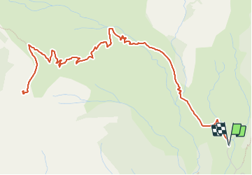
Trail Walking of 9.1 km to be discovered at Provence-Alpes-Côte d'Azur, Hautes-Alpes, Saint-Jean-Saint-Nicolas. This trail is proposed by Marco05.
Description
A la sortie de Pont du Fossé, prendre à gauche la direction des Richards. La route serpente pendant 6km.
Le parking est bien indiqué et évident.
Suivre la piste puis le sentier jusqu'au col du Palastre.
A cet endroit le sommet est évident sur la gauche.
On peut monter pleine pente ou bien prendre le sentier qui contourne par la gauche et beaucoup moins pentu.
Pour le final on s'équilibre un peu avec les mains, mais rien de très technique.
On peut redescendre à vue sur le col.
Positioning
Comments
Trails nearby
![Trail Walking Saint-Jean-Saint-Nicolas - Circuit de Costebelle - Photo](https://media.geolcdn.com/t/375/260/ext.jpg?maxdim=2&url=https%3A%2F%2Fservices.sitytrail.com%2FGeolivesWS%2FDownloadMedia.ashx%3FTrailID%3D269960%26Media%3Dfix__20140424150455.jpg)
![Walking Walking](https://static1.geolcdn.com/sitytour/trail-icons/101.png)
Walking
![](/images/other/stat-length.png)
![](https://static1.geolcdn.com/siteimages/upload/files/16400158638029165_repeat_loop_refresh_sync_direction_icon.png)
![Trail On foot Champoléon - Refuge du Tourond - Photo](https://media.geolcdn.com/t/375/260/42cbf5d1-e48d-4896-9483-7cb6a380b211.jpg&format=jpg&maxdim=2)
![On foot On foot](https://static1.geolcdn.com/sitytour/trail-icons/100.png)
On foot
![](/images/other/stat-length.png)
![](https://static1.geolcdn.com/siteimages/upload/files/16400158638029165_repeat_loop_refresh_sync_direction_icon.png)
![Trail Walking Champoléon - Méollion - Photo](https://media.geolcdn.com/t/375/260/da24cc78-a99a-4fa8-9dce-d97d6d7f39a5.jpg&format=jpg&maxdim=2)
![Walking Walking](https://static1.geolcdn.com/sitytour/trail-icons/101.png)
Walking
![](/images/other/stat-length.png)
![](https://static1.geolcdn.com/siteimages/upload/files/16400158638029165_repeat_loop_refresh_sync_direction_icon.png)
![Trail Walking Champoléon - Balade Vallée Champoléon - Photo](https://media.geolcdn.com/t/375/260/23c779ce-adcf-411d-9db1-4b3234bce8ff.jpg&format=jpg&maxdim=2)
![Walking Walking](https://static1.geolcdn.com/sitytour/trail-icons/101.png)
Walking
![](/images/other/stat-length.png)
![](https://static1.geolcdn.com/siteimages/upload/files/16400158638029165_repeat_loop_refresh_sync_direction_icon.png)
![Trail Touring skiing Saint-Jean-Saint-Nicolas - Soleil boeuf - Photo](https://media.geolcdn.com/t/375/260/845c7dbb-c2d0-4333-a1ea-f52a60db91cf.jpg&format=jpg&maxdim=2)
![Touring skiing Touring skiing](https://static1.geolcdn.com/sitytour/trail-icons/503.png)
Touring skiing
![](/images/other/stat-length.png)
![](https://static1.geolcdn.com/siteimages/upload/files/16400158638029165_repeat_loop_refresh_sync_direction_icon.png)
![Trail Touring skiing Saint-Jean-Saint-Nicolas - Soleil boeuf et petite remontée à Prouveyrat - Photo](https://media.geolcdn.com/t/375/260/24b9b2dd-138e-4875-9609-8a92cb5ef256.jpg&format=jpg&maxdim=2)
![Touring skiing Touring skiing](https://static1.geolcdn.com/sitytour/trail-icons/503.png)
Touring skiing
![](/images/other/stat-length.png)
![](https://static1.geolcdn.com/siteimages/upload/files/16400158638029165_repeat_loop_refresh_sync_direction_icon.png)
![Trail Touring skiing Saint-Jean-Saint-Nicolas - Le Palastre . Pic clos Lamiante - Photo](https://media.geolcdn.com/t/375/260/48549508-2dac-470b-a869-765cc826fbbc.jpg&format=jpg&maxdim=2)
![Touring skiing Touring skiing](https://static1.geolcdn.com/sitytour/trail-icons/503.png)
Touring skiing
![](/images/other/stat-length.png)
![](https://static1.geolcdn.com/siteimages/upload/files/16400158638029165_repeat_loop_refresh_sync_direction_icon.png)
![Trail Walking Champoléon - Refuge Tourond + Cascade 28/07/20 - Photo](https://media.geolcdn.com/t/375/260/e7d034e9-7e3b-42ad-9caa-76a3aa68be48.jpg&format=jpg&maxdim=2)
![Walking Walking](https://static1.geolcdn.com/sitytour/trail-icons/101.png)
Walking
![](/images/other/stat-length.png)
![](https://static1.geolcdn.com/siteimages/upload/files/16400158638029165_repeat_loop_refresh_sync_direction_icon.png)
![Trail Walking Saint-Michel-de-Chaillol - Tête ouest de Mal Cros 11/08/18 - Photo](https://media.geolcdn.com/t/375/260/8702d498-6db2-40a6-b115-ed3ce3d7c0b6.jpg&format=jpg&maxdim=2)
![Walking Walking](https://static1.geolcdn.com/sitytour/trail-icons/101.png)
Walking
![](/images/other/stat-length.png)
![](https://static1.geolcdn.com/siteimages/upload/files/16400158638029165_repeat_loop_refresh_sync_direction_icon.png)