![](/images/other/stat-length.png)
![Trail Walking Saint-Laurent-en-Royans - la roche des arnaud - Photo](https://media.geolcdn.com/t/1900/400/ext.pjpeg?maxdim=2&url=https%3A%2F%2Fstatic1.geolcdn.com%2Fsiteimages%2Fupload%2Ffiles%2F1553511878bg_sport_marche.png)
la roche des arnaud
hugo26
User
![Length](/images/other/stat-length.png)
Length
17.5 km
![Max alt](https://static1.geolcdn.com/siteimages/upload/files/1508320355ic_sort_altitude_max_24dp.png)
Max alt
1393 m
![Uphill gradient](https://static1.geolcdn.com/siteimages/upload/files/1508320355ic_sort_den_pos_24dp.png)
Uphill gradient
1186 m
![Km-Effort](/images/other/stat-length.png)
Km-Effort
33 km
![Min alt](https://static1.geolcdn.com/siteimages/upload/files/1508320355ic_sort_altitude_min_24dp.png)
Min alt
382 m
![Downhill gradient](https://static1.geolcdn.com/siteimages/upload/files/1508320355ic_sort_den_neg_24dp.png)
Downhill gradient
1186 m
![Boucle](https://static1.geolcdn.com/siteimages/upload/files/16400158638029165_repeat_loop_refresh_sync_direction_icon.png)
Boucle
Yes
Creation date :
2023-07-01 12:56:37.103
Updated on :
2023-07-01 13:00:22.089
![Walking](https://static1.geolcdn.com/sitytour/trail-icons/101.png)
7h33
Difficulty : Very difficult
![Scan this QR Code to open this trail in the SityTrail application](https://capi.geolives.com/qq0zvz2zws4bq2lad0pu/sitytour/trails/3718684/qr.png?size=200)
FREE GPS app for hiking
About
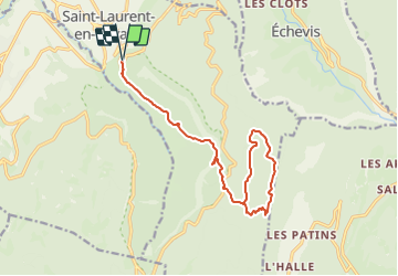
Trail Walking of 17.5 km to be discovered at Auvergne-Rhône-Alpes, Drôme, Saint-Laurent-en-Royans. This trail is proposed by hugo26.
Description
la roche des Arnaud en boucle par les crêtes puis retour par le sentier de monté vers la fin de la rando au départ de Saint laurrent en royans
Positioning
Country:
France
Region :
Auvergne-Rhône-Alpes
Department/Province :
Drôme
Municipality :
Saint-Laurent-en-Royans
Location:
Unknown
Start:(Dec)
Start:(UTM)
683650 ; 4987829 (31T) N.
Comments
Trails nearby
![Trail Walking Châtelus - Boucle Pas de l'Allier - Pas des Voutes - Photo](https://media.geolcdn.com/t/375/260/ext.jpg?maxdim=2&url=https%3A%2F%2Fservices.sitytrail.com%2FGeolivesWS%2FDownloadMedia.ashx%3FTrailID%3D105085%26Media%3D8675_1.jpg)
![Walking Walking](https://static1.geolcdn.com/sitytour/trail-icons/101.png)
Boucle Pas de l'Allier - Pas des Voutes
Walking
Medium
(1)
Châtelus,
Auvergne-Rhône-Alpes,
Isère,
France
![](/images/other/stat-length.png)
10.1 km | 22 km-effort
4h 30min
![](https://static1.geolcdn.com/siteimages/upload/files/16400158638029165_repeat_loop_refresh_sync_direction_icon.png)
Yes
![Trail Walking Saint-Laurent-en-Royans - 26 rocher des mines ARP - Photo](https://media.geolcdn.com/t/375/260/bd4f581f-b362-467f-a5ca-afa55317a017.jpg&format=jpg&maxdim=2)
![Walking Walking](https://static1.geolcdn.com/sitytour/trail-icons/101.png)
26 rocher des mines ARP
Walking
Very difficult
Saint-Laurent-en-Royans,
Auvergne-Rhône-Alpes,
Drôme,
France
![](/images/other/stat-length.png)
8.6 km | 16.2 km-effort
6h 53min
![](https://static1.geolcdn.com/siteimages/upload/files/16400158638029165_repeat_loop_refresh_sync_direction_icon.png)
Yes
![Trail Walking Sainte-Eulalie-en-Royans - 26 ste eulalie - Photo](https://media.geolcdn.com/t/375/260/cc17d7c1-039b-4811-aa20-433bfbe37107.jpg&format=jpg&maxdim=2)
![Walking Walking](https://static1.geolcdn.com/sitytour/trail-icons/101.png)
26 ste eulalie
Walking
Medium
Sainte-Eulalie-en-Royans,
Auvergne-Rhône-Alpes,
Drôme,
France
![](/images/other/stat-length.png)
14.8 km | 27 km-effort
6h 43min
![](https://static1.geolcdn.com/siteimages/upload/files/16400158638029165_repeat_loop_refresh_sync_direction_icon.png)
No
![Trail Walking Châtelus - 38 pabro charmatte - Photo](https://media.geolcdn.com/t/375/260/983fca8d-ac95-4180-878f-eb8932bd4279.jpg&format=jpg&maxdim=2)
![Walking Walking](https://static1.geolcdn.com/sitytour/trail-icons/101.png)
38 pabro charmatte
Walking
Difficult
Châtelus,
Auvergne-Rhône-Alpes,
Isère,
France
![](/images/other/stat-length.png)
11.4 km | 29 km-effort
7h 43min
![](https://static1.geolcdn.com/siteimages/upload/files/16400158638029165_repeat_loop_refresh_sync_direction_icon.png)
Yes
![Trail Walking Pont-en-Royans - 38 pont en Royans choranche presles - Photo](https://media.geolcdn.com/t/375/260/55a7031b-27da-4fe2-88f7-a5894b7e1ffc.jpg&format=jpg&maxdim=2)
![Walking Walking](https://static1.geolcdn.com/sitytour/trail-icons/101.png)
38 pont en Royans choranche presles
Walking
Difficult
Pont-en-Royans,
Auvergne-Rhône-Alpes,
Isère,
France
![](/images/other/stat-length.png)
15.4 km | 30 km-effort
6h 52min
![](https://static1.geolcdn.com/siteimages/upload/files/16400158638029165_repeat_loop_refresh_sync_direction_icon.png)
Yes
![Trail Walking Pont-en-Royans - 38 pont en Royans st andre - Photo](https://media.geolcdn.com/t/375/260/9999e3ad-9f99-41dc-bf89-768d521527c3.jpg&format=jpg&maxdim=2)
![Walking Walking](https://static1.geolcdn.com/sitytour/trail-icons/101.png)
38 pont en Royans st andre
Walking
Easy
Pont-en-Royans,
Auvergne-Rhône-Alpes,
Isère,
France
![](/images/other/stat-length.png)
14.1 km | 19.3 km-effort
3h 33min
![](https://static1.geolcdn.com/siteimages/upload/files/16400158638029165_repeat_loop_refresh_sync_direction_icon.png)
Yes
![Trail Walking Oriol-en-Royans - 26 pas de l écho - Photo](https://media.geolcdn.com/t/375/260/ac202026-42b8-42ae-9ed4-0d1c52688ae8.jpg&format=jpg&maxdim=2)
![Walking Walking](https://static1.geolcdn.com/sitytour/trail-icons/101.png)
26 pas de l écho
Walking
Medium
Oriol-en-Royans,
Auvergne-Rhône-Alpes,
Drôme,
France
![](/images/other/stat-length.png)
22 km | 36 km-effort
8h 42min
![](https://static1.geolcdn.com/siteimages/upload/files/16400158638029165_repeat_loop_refresh_sync_direction_icon.png)
Yes
![Trail Walking Pont-en-Royans - 38 pont en Royans serre cocu - Photo](https://media.geolcdn.com/t/375/260/72853ffa-a2a8-4453-a880-6a63c61d611f.jpg&format=jpg&maxdim=2)
![Walking Walking](https://static1.geolcdn.com/sitytour/trail-icons/101.png)
38 pont en Royans serre cocu
Walking
Medium
Pont-en-Royans,
Auvergne-Rhône-Alpes,
Isère,
France
![](/images/other/stat-length.png)
16 km | 29 km-effort
7h 44min
![](https://static1.geolcdn.com/siteimages/upload/files/16400158638029165_repeat_loop_refresh_sync_direction_icon.png)
Yes
![Trail Walking Châtelus - la grande cournouse - Photo](https://media.geolcdn.com/t/375/260/81ce0c57-e303-433f-a090-0d0401f39630.jpg&format=jpg&maxdim=2)
![Walking Walking](https://static1.geolcdn.com/sitytour/trail-icons/101.png)
la grande cournouse
Walking
Difficult
Châtelus,
Auvergne-Rhône-Alpes,
Isère,
France
![](/images/other/stat-length.png)
10.5 km | 26 km-effort
6h 34min
![](https://static1.geolcdn.com/siteimages/upload/files/16400158638029165_repeat_loop_refresh_sync_direction_icon.png)
Yes