Trail Walking Séguret - Séguret - cheval long - Photo
 M7184
M7184

User

© OpenStreetMap contributors
Length
Length
7.6 km
Max alt
Max alt
377 m
Uphill gradient
Uphill gradient
224 m
Km-Effort
Km-Effort  
10.6 km
Min alt
Min alt
217 m
Downhill gradient
Downhill gradient
223 m
Boucle
Boucle
Yes
Creation date :
2023-07-01 12:35:35.325
Updated on :
2023-07-02 16:09:43.134

(0 Reviews)

Walking
Walking
2h24
Difficulty : Medium

Scan this QR Code to open this trail in the SityTrail application

FREE GPS app for hiking

Logo SityTrail SityTrail

IGN / Geographical institutes

Download SityTrail from the App Store Download SityTrail from Google Play

Logo SityTrail SityTrail World

The world is yours!

Download SityTrail from the App Store Download SityTrail from Google Play Download SityTrail on Huawei AppGallery

About

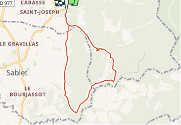
Trail Walking of 7.6 km to be discovered at Provence-Alpes-Côte d'Azur, Vaucluse, Séguret. This trail is proposed by M7184.

Description

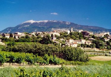
randonnée avec de belle vues sur les villages de Sablet et Rasteau, parking facile à Séguret.
En été vérifiez l'accès au massif forestier sur le site :
https://www.risque-prevention-incendie.fr/vaucluse/

Elevation profile

Positioning

Country:
France
Region :
Provence-Alpes-Côte d'Azur
Department/Province :
Vaucluse
Municipality :
Séguret
Location:
Unknown
Start:(UTM)
661638 ; 4896893 (31T) N.

Trails nearby

Trail Walking Séguret - 170917 EnCours - Photo
Walking
MarcheEtReve

Walking

Very easy
(1)
Séguret, Provence-Alpes-Côte d'Azur, Vaucluse, France
6.3 km | 9.8 km-effort
2h 8min
Yes
Trail Walking Gigondas - Dentelles Montmirail   - Gigondas - Photo
Walking
tracegps

Walking

Very difficult
(3)
Gigondas, Provence-Alpes-Côte d'Azur, Vaucluse, France
12.4 km | 22 km-effort
7h 0min
Yes
Trail Cycle Vaison-la-Romaine - Circuit Vélo - Les villages des Templiers (entre Aygues et Ouvèze) Variante - Vaison-la-Romaine - Photo
Cycle
tracegps

Cycle

Medium
(2)
Vaison-la-Romaine, Provence-Alpes-Côte d'Azur, Vaucluse, France
33 km | 40 km-effort
3h 0min
Yes
Trail Cycle Vaison-la-Romaine - Circuit Vélo - Les villages médiévaux - Vaison la Romaine - Photo
Cycle
tracegps

Cycle

Medium
(1)
Vaison-la-Romaine, Provence-Alpes-Côte d'Azur, Vaucluse, France
27 km | 33 km-effort
2h 0min
Yes
Trail Walking Gigondas - 84 dentelles montmirail - Photo
Walking
GUIDE
randodyssée

Walking

Difficult
Gigondas, Provence-Alpes-Côte d'Azur, Vaucluse, France
14.6 km | 25 km-effort
8h 18min
Yes
Trail Walking Gigondas - Gigondas Dentelles Sarasines Grande Montagne  - Photo
Walking
GUIDE
nadinebondoux

Walking

Difficult
(1)
Gigondas, Provence-Alpes-Côte d'Azur, Vaucluse, France
15.4 km | 26 km-effort
5h 57min
Yes
Trail Walking Gigondas - Grand Montmirail par 3 Yeux - Photo
Walking
Drailloun

Walking

Medium
(2)
Gigondas, Provence-Alpes-Côte d'Azur, Vaucluse, France
13.3 km | 21 km-effort
4h 29min
Yes
Trail Walking Gigondas - dentelles de Montmirail  - Photo
Walking
fmarois

Walking

Very easy
(1)
Gigondas, Provence-Alpes-Côte d'Azur, Vaucluse, France
15.7 km | 26 km-effort
8h 9min
Yes
Trail Walking Roaix - Alentour de Roaix - Photo
Walking
atuttabirra

Walking

Very easy
(2)
Roaix, Provence-Alpes-Côte d'Azur, Vaucluse, France
10.1 km | 13.5 km-effort
2h 42min
Yes


Close
My subscriptions