![](/images/other/stat-length.png)
![Trail Walking Saint-Gildas-des-Bois - Sentier de la ferme école de la Croix rouge - Photo](https://media.geolcdn.com/t/1900/400/ext.pjpeg?maxdim=2&url=https%3A%2F%2Fstatic1.geolcdn.com%2Fsiteimages%2Fupload%2Ffiles%2F1553511878bg_sport_marche.png)
Sentier de la ferme école de la Croix rouge
phila128
User
![Length](/images/other/stat-length.png)
Length
14.3 km
![Max alt](https://static1.geolcdn.com/siteimages/upload/files/1508320355ic_sort_altitude_max_24dp.png)
Max alt
55 m
![Uphill gradient](https://static1.geolcdn.com/siteimages/upload/files/1508320355ic_sort_den_pos_24dp.png)
Uphill gradient
84 m
![Km-Effort](/images/other/stat-length.png)
Km-Effort
15.5 km
![Min alt](https://static1.geolcdn.com/siteimages/upload/files/1508320355ic_sort_altitude_min_24dp.png)
Min alt
-2 m
![Downhill gradient](https://static1.geolcdn.com/siteimages/upload/files/1508320355ic_sort_den_neg_24dp.png)
Downhill gradient
84 m
![Boucle](https://static1.geolcdn.com/siteimages/upload/files/16400158638029165_repeat_loop_refresh_sync_direction_icon.png)
Boucle
Yes
Creation date :
2023-06-29 08:25:33.898
Updated on :
2023-06-29 12:32:08.78
![Walking](https://static1.geolcdn.com/sitytour/trail-icons/101.png)
3h06
Difficulty : Medium
![Scan this QR Code to open this trail in the SityTrail application](https://capi.geolives.com/qq0zvz2zws4bq2lad0pu/sitytour/trails/3716667/qr.png?size=200)
FREE GPS app for hiking
About
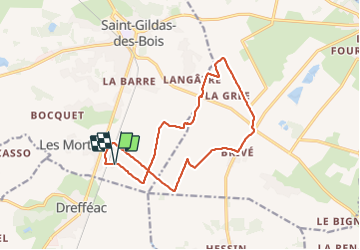
Trail Walking of 14.3 km to be discovered at Pays de la Loire, Loire-Atlantique, Saint-Gildas-des-Bois. This trail is proposed by phila128.
Description
Une partie (début et fin) dans le marais de Brivé. Ensuite on monte à la Croix-Rouge. Chemins agricoles et un peu de route. Ne pas faire quand c'est trop sec ni en hivers car trop d'eau.
Positioning
Country:
France
Region :
Pays de la Loire
Department/Province :
Loire-Atlantique
Municipality :
Saint-Gildas-des-Bois
Location:
Unknown
Start:(Dec)
Start:(UTM)
571962 ; 5259719 (30T) N.
Comments
Trails nearby
![Trail Walking Saint-Gildas-des-Bois - circuit des pins - Photo](https://media.geolcdn.com/t/375/260/620585ac-e4ed-4181-9662-9c1086f1c5f8.jpg&format=jpg&maxdim=2)
![Walking Walking](https://static1.geolcdn.com/sitytour/trail-icons/101.png)
circuit des pins
Walking
Very easy
Saint-Gildas-des-Bois,
Pays de la Loire,
Loire-Atlantique,
France
![](/images/other/stat-length.png)
4 km | 4.9 km-effort
1h 4min
![](https://static1.geolcdn.com/siteimages/upload/files/16400158638029165_repeat_loop_refresh_sync_direction_icon.png)
Yes
![Trail Mountain bike Sainte-Anne-sur-Brivet - ste Anne sur Brivet - Photo](https://media.geolcdn.com/t/375/260/ext.jpg?maxdim=2&url=https%3A%2F%2Fstatic1.geolcdn.com%2Fsiteimages%2Fupload%2Ffiles%2F1524743154velo.jpg)
![Mountain bike Mountain bike](https://static1.geolcdn.com/sitytour/trail-icons/202.png)
ste Anne sur Brivet
Mountain bike
Difficult
Sainte-Anne-sur-Brivet,
Pays de la Loire,
Loire-Atlantique,
France
![](/images/other/stat-length.png)
25 km | 27 km-effort
2h 41min
![](https://static1.geolcdn.com/siteimages/upload/files/16400158638029165_repeat_loop_refresh_sync_direction_icon.png)
Yes
![Trail Walking Sainte-Anne-sur-Brivet - Circuit des landes - Photo](https://media.geolcdn.com/t/375/260/ext.jpg?maxdim=2&url=https%3A%2F%2Fstatic1.geolcdn.com%2Fsiteimages%2Fupload%2Ffiles%2F1553511878bg_sport_marche.png)
![Walking Walking](https://static1.geolcdn.com/sitytour/trail-icons/101.png)
Circuit des landes
Walking
Easy
Sainte-Anne-sur-Brivet,
Pays de la Loire,
Loire-Atlantique,
France
![](/images/other/stat-length.png)
13.3 km | 14.5 km-effort
3h 20min
![](https://static1.geolcdn.com/siteimages/upload/files/16400158638029165_repeat_loop_refresh_sync_direction_icon.png)
Yes
![Trail Walking Drefféac - pon - Photo](https://media.geolcdn.com/t/375/260/ext.jpg?maxdim=2&url=https%3A%2F%2Fstatic1.geolcdn.com%2Fsiteimages%2Fupload%2Ffiles%2F1553511878bg_sport_marche.png)
![Walking Walking](https://static1.geolcdn.com/sitytour/trail-icons/101.png)
pon
Walking
Easy
Drefféac,
Pays de la Loire,
Loire-Atlantique,
France
![](/images/other/stat-length.png)
11.7 km | 12.7 km-effort
2h 53min
![](https://static1.geolcdn.com/siteimages/upload/files/16400158638029165_repeat_loop_refresh_sync_direction_icon.png)
Yes
![Trail Walking Saint-Gildas-des-Bois - St gildes - Photo](https://media.geolcdn.com/t/375/260/ext.jpg?maxdim=2&url=https%3A%2F%2Fstatic1.geolcdn.com%2Fsiteimages%2Fupload%2Ffiles%2F1553511878bg_sport_marche.png)
![Walking Walking](https://static1.geolcdn.com/sitytour/trail-icons/101.png)
St gildes
Walking
Easy
Saint-Gildas-des-Bois,
Pays de la Loire,
Loire-Atlantique,
France
![](/images/other/stat-length.png)
15.5 km | 18.1 km-effort
3h 0min
![](https://static1.geolcdn.com/siteimages/upload/files/16400158638029165_repeat_loop_refresh_sync_direction_icon.png)
Yes
![Trail Walking Sainte-Anne-sur-Brivet - St Anne sur brivet - De St Omer au canal - Photo](https://media.geolcdn.com/t/375/260/ext.jpg?maxdim=2&url=https%3A%2F%2Fstatic1.geolcdn.com%2Fsiteimages%2Fupload%2Ffiles%2F1553511878bg_sport_marche.png)
![Walking Walking](https://static1.geolcdn.com/sitytour/trail-icons/101.png)
St Anne sur brivet - De St Omer au canal
Walking
Very easy
Sainte-Anne-sur-Brivet,
Pays de la Loire,
Loire-Atlantique,
France
![](/images/other/stat-length.png)
7.2 km | 7.6 km-effort
1h 36min
![](https://static1.geolcdn.com/siteimages/upload/files/16400158638029165_repeat_loop_refresh_sync_direction_icon.png)
Yes
![Trail Cycle Sainte-Anne-sur-Brivet - 2011-07-03 13h05m25 - Photo](https://media.geolcdn.com/t/375/260/ext.jpg?maxdim=2&url=https%3A%2F%2Fstatic1.geolcdn.com%2Fsiteimages%2Fupload%2Ffiles%2F1524743154velo.jpg)
![Cycle Cycle](https://static1.geolcdn.com/sitytour/trail-icons/200.png)
2011-07-03 13h05m25
Cycle
Medium
Sainte-Anne-sur-Brivet,
Pays de la Loire,
Loire-Atlantique,
France
![](/images/other/stat-length.png)
35 km | 38 km-effort
Unknown
![](https://static1.geolcdn.com/siteimages/upload/files/16400158638029165_repeat_loop_refresh_sync_direction_icon.png)
Yes