![](/images/other/stat-length.png)
![Trail Walking Annot - Rando gastro Roncharel - Photo](https://media.geolcdn.com/t/1900/400/4e3f8487-9887-4ec3-94b2-d5bbd50aefe8.jpg&format=pjpeg&maxdim=2)
Rando gastro Roncharel
Marchopier
User
![Length](/images/other/stat-length.png)
![Max alt](https://static1.geolcdn.com/siteimages/upload/files/1508320355ic_sort_altitude_max_24dp.png)
![Uphill gradient](https://static1.geolcdn.com/siteimages/upload/files/1508320355ic_sort_den_pos_24dp.png)
![Km-Effort](/images/other/stat-length.png)
![Min alt](https://static1.geolcdn.com/siteimages/upload/files/1508320355ic_sort_altitude_min_24dp.png)
![Downhill gradient](https://static1.geolcdn.com/siteimages/upload/files/1508320355ic_sort_den_neg_24dp.png)
![Boucle](https://static1.geolcdn.com/siteimages/upload/files/16400158638029165_repeat_loop_refresh_sync_direction_icon.png)
![Walking](https://static1.geolcdn.com/sitytour/trail-icons/101.png)
2h42
Difficulty : Medium
![Scan this QR Code to open this trail in the SityTrail application](https://capi.geolives.com/qq0zvz2zws4bq2lad0pu/sitytour/trails/3716435/qr.png?size=200)
FREE GPS app for hiking
About
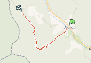
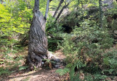
Trail Walking of 5.8 km to be discovered at Provence-Alpes-Côte d'Azur, Alpes-de-Haute-Provence, Annot. This trail is proposed by Marchopier.
Description
Départ de la place d'Annot, devant la Mairie, pour franchir la Vaïre en direction de Colle Basse. Après une portion de route ,un sentier à droite amène au-dessus du terrain d'enduro, où il faut traverser la route pour suivre à gauche le sentier de pays balisé jaune. Prendre à gauche sur la piste pendant quelques dizaines de mètres et à la balise Piste de Palluy, prendre à droite en direction de Chemin de ceinture, Colle Basse. Arrivée au chemin de ceinture prendre à droite en direction du Gîte de Roncharel.
Laisser ensuite la direction Colle Basse sur le sentier de gauche, poursuivre sur la piste jusqu'au sentier suivant à gauche qui rejoint la route. Sur la route après une centaine de mètres le Gîte de Roncharel est atteint après 6 km, 560 mètres de montée
Positioning
Comments
Trails nearby
![Trail On foot Annot - Le Grès d'Annot - Photo](https://media.geolcdn.com/t/375/260/d494c9f4-04f5-4184-be97-f5fea23e1191.jpeg&format=jpg&maxdim=2)
![On foot On foot](https://static1.geolcdn.com/sitytour/trail-icons/100.png)
On foot
![](/images/other/stat-length.png)
![](https://static1.geolcdn.com/siteimages/upload/files/16400158638029165_repeat_loop_refresh_sync_direction_icon.png)
![Trail Walking Annot - J4 Annot - Photo](https://media.geolcdn.com/t/375/260/be9d9d12-b8a6-45a8-bd70-6f8cacf32730.jpg&format=jpg&maxdim=2)
![Walking Walking](https://static1.geolcdn.com/sitytour/trail-icons/101.png)
Walking
![](/images/other/stat-length.png)
![](https://static1.geolcdn.com/siteimages/upload/files/16400158638029165_repeat_loop_refresh_sync_direction_icon.png)
![Walking Walking](https://static1.geolcdn.com/sitytour/trail-icons/101.png)
Walking
![](/images/other/stat-length.png)
![](https://static1.geolcdn.com/siteimages/upload/files/16400158638029165_repeat_loop_refresh_sync_direction_icon.png)
![Trail Walking Annot - Les grès d'Annot - Photo](https://media.geolcdn.com/t/375/260/ext.jpg?maxdim=2&url=https%3A%2F%2Fstatic1.geolcdn.com%2Fsiteimages%2Fupload%2Ffiles%2F1553511878bg_sport_marche.png)
![Walking Walking](https://static1.geolcdn.com/sitytour/trail-icons/101.png)
Walking
![](/images/other/stat-length.png)
![](https://static1.geolcdn.com/siteimages/upload/files/16400158638029165_repeat_loop_refresh_sync_direction_icon.png)
![Trail Walking Annot - Rando bleue - Photo](https://media.geolcdn.com/t/375/260/94ab7e9b-3b20-4840-b15c-d5a4c12ad390.jpg&format=jpg&maxdim=2)
![Walking Walking](https://static1.geolcdn.com/sitytour/trail-icons/101.png)
Walking
![](/images/other/stat-length.png)
![](https://static1.geolcdn.com/siteimages/upload/files/16400158638029165_repeat_loop_refresh_sync_direction_icon.png)
![Trail Walking Braux - Rando Pieŕre qui tremble Chabrieres Peloussis Argenton - Photo](https://media.geolcdn.com/t/375/260/cfc0cc00-9a69-459b-9e00-f152d8d54736.jpg&format=jpg&maxdim=2)
![Walking Walking](https://static1.geolcdn.com/sitytour/trail-icons/101.png)
Walking
![](/images/other/stat-length.png)
![](https://static1.geolcdn.com/siteimages/upload/files/16400158638029165_repeat_loop_refresh_sync_direction_icon.png)
![Trail Walking Annot - Grès d'Annot Carte IGN 3541OT - Photo](https://media.geolcdn.com/t/375/260/9f9453a3-f8fb-41f4-87f9-67579e26dbf0.jpg&format=jpg&maxdim=2)
![Walking Walking](https://static1.geolcdn.com/sitytour/trail-icons/101.png)
Walking
![](/images/other/stat-length.png)
![](https://static1.geolcdn.com/siteimages/upload/files/16400158638029165_repeat_loop_refresh_sync_direction_icon.png)
![Trail Walking Annot - Les grès d'Annot-20-05-22 - Photo](https://media.geolcdn.com/t/375/260/3872c580-3dd5-4977-8057-6ad4a77228f8.jpg&format=jpg&maxdim=2)
![Walking Walking](https://static1.geolcdn.com/sitytour/trail-icons/101.png)
Walking
![](/images/other/stat-length.png)
![](https://static1.geolcdn.com/siteimages/upload/files/16400158638029165_repeat_loop_refresh_sync_direction_icon.png)
![Trail Walking Annot - LES GRÈS D'ANNOT - Photo](https://media.geolcdn.com/t/375/260/8378a4cb-00ce-46f7-aa61-d9a6ee4d8606.jpg&format=jpg&maxdim=2)
![Walking Walking](https://static1.geolcdn.com/sitytour/trail-icons/101.png)
Walking
![](/images/other/stat-length.png)
![](https://static1.geolcdn.com/siteimages/upload/files/16400158638029165_repeat_loop_refresh_sync_direction_icon.png)