Trail Walking Pray - Pray - Photo
 guydu41
guydu41

User

© OpenStreetMap contributors
Length
Length
11.3 km
Max alt
Max alt
140 m
Uphill gradient
Uphill gradient
64 m
Km-Effort
Km-Effort  
12.1 km
Min alt
Min alt
114 m
Downhill gradient
Downhill gradient
63 m
Boucle
Boucle
Yes
Creation date :
2023-06-27 06:09:02.621
Updated on :
2023-06-27 13:42:45.133

(0 Reviews)

Walking
Walking
2h45
Difficulty : Easy

Scan this QR Code to open this trail in the SityTrail application

FREE GPS app for hiking

Logo SityTrail SityTrail

IGN / Geographical institutes

Download SityTrail from the App Store Download SityTrail from Google Play

Logo SityTrail SityTrail World

The world is yours!

Download SityTrail from the App Store Download SityTrail from Google Play Download SityTrail on Huawei AppGallery

About

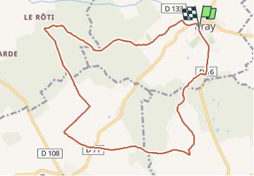
Trail Walking of 11.3 km to be discovered at Centre-Loire Valley, Loir-et-Cher, Pray. This trail is proposed by guydu41.

Description

Petite randonnée très agréable sur des chemins et sentiers dans les bois et champs au Sud-Ouest de Pray.
Le plus étonnant, c'est la fontaine à manivelle en bordure de la D71 au milieu des champs ?
Note : A ne pas faire en période de chasse

Elevation profile

Photos

Positioning

Country:
France
Region :
Centre-Loire Valley
Department/Province :
Loir-et-Cher
Municipality :
Pray
Location:
Unknown
Start:(UTM)
358535 ; 5281950 (31T) N.

Trails nearby

Trail Walking Pray - Pray - Photo
Walking
Michel Frain

Walking

Very easy
Pray, Centre-Loire Valley, Loir-et-Cher, France
18.7 km | 20 km-effort
4h 9min
Yes
Trail Walking Landes-le-Gaulois - Landes le Gaulois BF - Photo
Walking
nelly41

Walking

Difficult
Landes-le-Gaulois, Centre-Loire Valley, Loir-et-Cher, France
14.6 km | 15.9 km-effort
3h 0min
Yes


Close
My subscriptions