![](/images/other/stat-length.png)
![Trail Walking Cerfontaine - SILENRIEUX _ Marche Fédérale _ NA _ 24/06/2023 - Photo](https://media.geolcdn.com/t/1900/400/c023e8f1-0ef5-45e1-b07f-6f5163515d49.jpg&format=pjpeg&maxdim=2)
SILENRIEUX _ Marche Fédérale _ NA _ 24/06/2023
jeangulu
User
![Length](/images/other/stat-length.png)
Length
23 km
![Max alt](https://static1.geolcdn.com/siteimages/upload/files/1508320355ic_sort_altitude_max_24dp.png)
Max alt
285 m
![Uphill gradient](https://static1.geolcdn.com/siteimages/upload/files/1508320355ic_sort_den_pos_24dp.png)
Uphill gradient
478 m
![Km-Effort](/images/other/stat-length.png)
Km-Effort
29 km
![Min alt](https://static1.geolcdn.com/siteimages/upload/files/1508320355ic_sort_altitude_min_24dp.png)
Min alt
178 m
![Downhill gradient](https://static1.geolcdn.com/siteimages/upload/files/1508320355ic_sort_den_neg_24dp.png)
Downhill gradient
478 m
![Boucle](https://static1.geolcdn.com/siteimages/upload/files/16400158638029165_repeat_loop_refresh_sync_direction_icon.png)
Boucle
Yes
Creation date :
2023-06-24 08:13:08.937
Updated on :
2023-07-08 18:38:43.392
![Walking](https://static1.geolcdn.com/sitytour/trail-icons/101.png)
5h14
Difficulty : Medium
![Scan this QR Code to open this trail in the SityTrail application](https://capi.geolives.com/qq0zvz2zws4bq2lad0pu/sitytour/trails/3710630/qr.png?size=200)
FREE GPS app for hiking
About
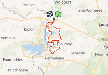
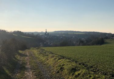
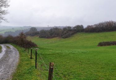
Trail Walking of 23 km to be discovered at Wallonia, Namur, Cerfontaine. This trail is proposed by jeangulu.
Description
Organisateur : NA 051 _ LES GODASSES DE FRAIRE.
- Marche de l'Eau d'Heure.
Point de départ : Salle <<La Silène>> _ Rue Nou Pré 1_ 5630 - SILENRIEUX.
Carte IGN : 52/7
Positioning
Country:
Belgium
Region :
Wallonia
Department/Province :
Namur
Municipality :
Cerfontaine
Location:
Unknown
Start:(Dec)
Start:(UTM)
600719 ; 5564408 (31U) N.
Comments
Trails nearby
![Trail Walking Walcourt - GG-Na-17_Walcourt - Philippeville - Photo](https://media.geolcdn.com/t/375/260/0ead20f8-4d85-41da-a61f-64e7e946f31c.jpg&format=jpg&maxdim=2)
![Walking Walking](https://static1.geolcdn.com/sitytour/trail-icons/101.png)
GG-Na-17_Walcourt - Philippeville
Walking
Very difficult
(2)
Walcourt,
Wallonia,
Namur,
Belgium
![](/images/other/stat-length.png)
21 km | 26 km-effort
5h 9min
![](https://static1.geolcdn.com/siteimages/upload/files/16400158638029165_repeat_loop_refresh_sync_direction_icon.png)
No
![Trail Walking Cerfontaine - La balade du Ballonnet - Photo](https://media.geolcdn.com/t/375/260/ext.jpg?maxdim=2&url=https%3A%2F%2Fservices.sitytrail.com%2FGeolivesWS%2FDownloadMedia.ashx%3FTrailID%3D661211%26Media%3Df8ef018a-8a4e-43e9-8982-4175f97a626c.jpg)
![Walking Walking](https://static1.geolcdn.com/sitytour/trail-icons/101.png)
La balade du Ballonnet
Walking
Very easy
(6)
Cerfontaine,
Wallonia,
Namur,
Belgium
![](/images/other/stat-length.png)
4.2 km | 5.2 km-effort
1h 12min
![](https://static1.geolcdn.com/siteimages/upload/files/16400158638029165_repeat_loop_refresh_sync_direction_icon.png)
Yes
![Trail Walking Froidchapelle - Du Lac de l'Eau d'Heure au Lac du Ry Jaune - Photo](https://media.geolcdn.com/t/375/260/ext.jpg?maxdim=2&url=https%3A%2F%2Fservices.sitytrail.com%2FGeolivesWS%2FDownloadMedia.ashx%3FTrailID%3D379812%26Media%3Dd36c7a2e-70fd-44ad-a77a-7190af56fd8b.JPG)
![Walking Walking](https://static1.geolcdn.com/sitytour/trail-icons/101.png)
Du Lac de l'Eau d'Heure au Lac du Ry Jaune
Walking
Very easy
(3)
Froidchapelle,
Wallonia,
Hainaut,
Belgium
![](/images/other/stat-length.png)
7.5 km | 9.4 km-effort
2h 6min
![](https://static1.geolcdn.com/siteimages/upload/files/16400158638029165_repeat_loop_refresh_sync_direction_icon.png)
Yes
![Trail Walking Froidchapelle - Marche ADEPS à Boussu-lez-Walcourt - Photo](https://media.geolcdn.com/t/375/260/ext.jpg?maxdim=2&url=https%3A%2F%2Fservices.sitytrail.com%2FGeolivesWS%2FDownloadMedia.ashx%3FTrailID%3D251033%26Media%3D06de1a7a-a6bd-4c9d-b2ff-1e6fcd4fa4cd.JPG)
![Walking Walking](https://static1.geolcdn.com/sitytour/trail-icons/101.png)
Marche ADEPS à Boussu-lez-Walcourt
Walking
Easy
(1)
Froidchapelle,
Wallonia,
Hainaut,
Belgium
![](/images/other/stat-length.png)
10.4 km | 12.8 km-effort
2h 47min
![](https://static1.geolcdn.com/siteimages/upload/files/16400158638029165_repeat_loop_refresh_sync_direction_icon.png)
Yes
![Trail Walking Walcourt - Promenade à Chastrès - Photo](https://media.geolcdn.com/t/375/260/ext.jpg?maxdim=2&url=https%3A%2F%2Fservices.sitytrail.com%2FGeolivesWS%2FDownloadMedia.ashx%3FTrailID%3D117187%26Media%3D3da6a3b3-b81a-4fdc-a255-5d93ffb1cd0b.JPG)
![Walking Walking](https://static1.geolcdn.com/sitytour/trail-icons/101.png)
Promenade à Chastrès
Walking
Very easy
(1)
Walcourt,
Wallonia,
Namur,
Belgium
![](/images/other/stat-length.png)
4.7 km | 6 km-effort
1h 10min
![](https://static1.geolcdn.com/siteimages/upload/files/16400158638029165_repeat_loop_refresh_sync_direction_icon.png)
Yes
![Trail Walking Walcourt - Randonnée autour de Walcourt - Photo](https://media.geolcdn.com/t/375/260/a37238d0-f00c-4fff-8a56-6d6b6e8a9220.jpg&format=jpg&maxdim=2)
![Walking Walking](https://static1.geolcdn.com/sitytour/trail-icons/101.png)
Randonnée autour de Walcourt
Walking
Medium
(2)
Walcourt,
Wallonia,
Namur,
Belgium
![](/images/other/stat-length.png)
16 km | 20 km-effort
3h 43min
![](https://static1.geolcdn.com/siteimages/upload/files/16400158638029165_repeat_loop_refresh_sync_direction_icon.png)
Yes
![Trail Walking Froidchapelle - Le Tour du lac de la Plate Taille - Photo](https://media.geolcdn.com/t/375/260/ext.jpg?maxdim=2&url=https%3A%2F%2Fstatic1.geolcdn.com%2Fsiteimages%2Fupload%2Ffiles%2F1553511878bg_sport_marche.png)
![Walking Walking](https://static1.geolcdn.com/sitytour/trail-icons/101.png)
Le Tour du lac de la Plate Taille
Walking
Easy
(3)
Froidchapelle,
Wallonia,
Hainaut,
Belgium
![](/images/other/stat-length.png)
15.8 km | 18 km-effort
4h 0min
![](https://static1.geolcdn.com/siteimages/upload/files/16400158638029165_repeat_loop_refresh_sync_direction_icon.png)
Yes
![Trail Walking Froidchapelle - Du lac de l'Eau d'Heure vers la Plate Taille - Photo](https://media.geolcdn.com/t/375/260/ext.jpg?maxdim=2&url=https%3A%2F%2Fstatic1.geolcdn.com%2Fsiteimages%2Fupload%2Ffiles%2F1553511878bg_sport_marche.png)
![Walking Walking](https://static1.geolcdn.com/sitytour/trail-icons/101.png)
Du lac de l'Eau d'Heure vers la Plate Taille
Walking
Easy
(4)
Froidchapelle,
Wallonia,
Hainaut,
Belgium
![](/images/other/stat-length.png)
13.7 km | 16.2 km-effort
3h 20min
![](https://static1.geolcdn.com/siteimages/upload/files/16400158638029165_repeat_loop_refresh_sync_direction_icon.png)
Yes
![Trail Walking Walcourt - Balade à Walcourt - Photo](https://media.geolcdn.com/t/375/260/cc15b3fa-e158-4d51-b096-71bef2cb45f1.jpeg&format=jpg&maxdim=2)
![Walking Walking](https://static1.geolcdn.com/sitytour/trail-icons/101.png)
Balade à Walcourt
Walking
Medium
Walcourt,
Wallonia,
Namur,
Belgium
![](/images/other/stat-length.png)
5.9 km | 7.3 km-effort
1h 39min
![](https://static1.geolcdn.com/siteimages/upload/files/16400158638029165_repeat_loop_refresh_sync_direction_icon.png)
Yes