![](/images/other/stat-length.png)
![Trail Walking Eyne - La vallée d'Eyne - Photo](https://media.geolcdn.com/t/1900/400/be69964d-c4e7-4d39-babf-3870ad4e1a16.jpg&format=pjpeg&maxdim=2)
La vallée d'Eyne
suresnois
User
![Length](/images/other/stat-length.png)
![Max alt](https://static1.geolcdn.com/siteimages/upload/files/1508320355ic_sort_altitude_max_24dp.png)
![Uphill gradient](https://static1.geolcdn.com/siteimages/upload/files/1508320355ic_sort_den_pos_24dp.png)
![Km-Effort](/images/other/stat-length.png)
![Min alt](https://static1.geolcdn.com/siteimages/upload/files/1508320355ic_sort_altitude_min_24dp.png)
![Downhill gradient](https://static1.geolcdn.com/siteimages/upload/files/1508320355ic_sort_den_neg_24dp.png)
![Boucle](https://static1.geolcdn.com/siteimages/upload/files/16400158638029165_repeat_loop_refresh_sync_direction_icon.png)
![Walking](https://static1.geolcdn.com/sitytour/trail-icons/101.png)
7h08
Difficulty : Difficult
![Scan this QR Code to open this trail in the SityTrail application](https://capi.geolives.com/qq0zvz2zws4bq2lad0pu/sitytour/trails/3709671/qr.png?size=200)
FREE GPS app for hiking
About
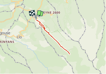
Trail Walking of 11.2 km to be discovered at Occitania, Pyrénées-Orientales, Eyne. This trail is proposed by suresnois.
Description
On se gare sur le parking aménagé à la sortie du village d'Eyne,
On prends le sentier « Réserve botanique », celui-ci monte dans la forêt, attention à bien refermer les portillons car on emprunte des chemins d'estives, On prends la piste à gauche, On remarquera l'orri, bien conservé, à droite, On continue de montée à travers la forêt en suivant le canal, Après la forêt le sentier continue à travers les estives, attention aux animaux qui sont en total liberté, On remarquera un autre orri de l'autre côté du torrent, Pour rejoindre la cascade continuer le sentier qui serpente à travers les rochers, attention le sentier peu être glissant à certaines périodes car de l'eau ruisselle, Arrivée sur un méplat prendre le petit sentier à droite, pas de balisage suivre la trace GPS, On revient au parking par le même chemin,
Attention le sentier est caillouteux parfois glissant, Ne pas faire par de très forte chaleur,
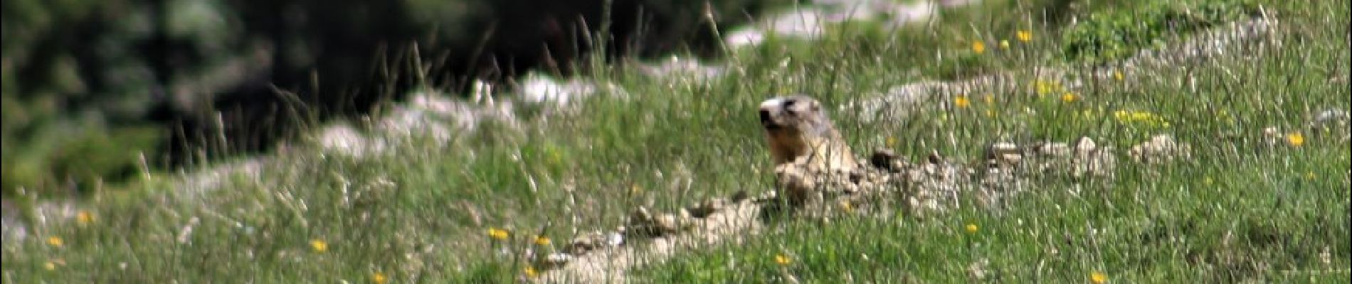
Ne pas effrayer les vaches et les chevaux,
Ne pas cueillir les fleurs
Ramener vos déchets,
Distance 11km
Dénivelé 500m
Durée sans les pauses 4h
Pour info :
Si vous partez seul prévenir un proche de votre itinéraire et de la durée,
Chaussures de marche, bâtons, GPS, carte de la randonnée avec l'itinéraire,,,
Apportez suffisamment d'eau, des en cas (fruits sec, barres de céréales,,,)
Selon les saisons : bonnet, gants, vêtements chauds, casquette, lunettes de soleil, crème solaire
Positioning
Comments
Trails nearby
![Trail Walking Eyne - Eyne,col de Nuria,pic d'Eyne,Torre d'Eyne,Eyne. - Photo](https://media.geolcdn.com/t/375/260/ext.jpg?maxdim=2&url=https%3A%2F%2Fservices.sitytrail.com%2FGeolivesWS%2FDownloadMedia.ashx%3FTrailID%3D530520%26Media%3D20150811115220.jpg)
![Walking Walking](https://static1.geolcdn.com/sitytour/trail-icons/101.png)
Walking
![](/images/other/stat-length.png)
![](https://static1.geolcdn.com/siteimages/upload/files/16400158638029165_repeat_loop_refresh_sync_direction_icon.png)
![Trail Snowshoes Font-Romeu-Odeillo-Via - pic dels moros - Photo](https://media.geolcdn.com/t/375/260/ext.jpg?maxdim=2&url=https%3A%2F%2Fservices.sitytrail.com%2FGeolivesWS%2FDownloadMedia.ashx%3FTrailID%3D509986%26Media%3Dfix__20140323122816.jpg)
![Snowshoes Snowshoes](https://static1.geolcdn.com/sitytour/trail-icons/504.png)
Snowshoes
![](/images/other/stat-length.png)
![](https://static1.geolcdn.com/siteimages/upload/files/16400158638029165_repeat_loop_refresh_sync_direction_icon.png)
![Trail Walking Font-Romeu-Odeillo-Via - Font Romeu Egat - Photo](https://media.geolcdn.com/t/375/260/ext.jpg?maxdim=2&url=https%3A%2F%2Fservices.sitytrail.com%2FGeolivesWS%2FDownloadMedia.ashx%3FTrailID%3D555215%26Media%3D20160418074519.jpg)
![Walking Walking](https://static1.geolcdn.com/sitytour/trail-icons/101.png)
Walking
![](/images/other/stat-length.png)
![](https://static1.geolcdn.com/siteimages/upload/files/16400158638029165_repeat_loop_refresh_sync_direction_icon.png)
![Trail Snowshoes Font-Romeu-Odeillo-Via - Pic dels Moros avec Pierre - Photo](https://media.geolcdn.com/t/375/260/ext.jpg?maxdim=2&url=https%3A%2F%2Fservices.sitytrail.com%2FGeolivesWS%2FDownloadMedia.ashx%3FTrailID%3D542171%26Media%3Dfix__20160322124727.jpg)
![Snowshoes Snowshoes](https://static1.geolcdn.com/sitytour/trail-icons/504.png)
Snowshoes
![](/images/other/stat-length.png)
![](https://static1.geolcdn.com/siteimages/upload/files/16400158638029165_repeat_loop_refresh_sync_direction_icon.png)
![Trail Walking Planès - étang de Planès - Photo](https://media.geolcdn.com/t/375/260/ext.jpg?maxdim=2&url=https%3A%2F%2Fservices.sitytrail.com%2FGeolivesWS%2FDownloadMedia.ashx%3FTrailID%3D330882%26Media%3Dfix__20140804135744.jpg)
![Walking Walking](https://static1.geolcdn.com/sitytour/trail-icons/101.png)
Walking
![](/images/other/stat-length.png)
![](https://static1.geolcdn.com/siteimages/upload/files/16400158638029165_repeat_loop_refresh_sync_direction_icon.png)
![Trail Walking Égat - La croix d'Egat - Photo](https://media.geolcdn.com/t/375/260/ext.jpg?maxdim=2&url=https%3A%2F%2Fservices.sitytrail.com%2FGeolivesWS%2FDownloadMedia.ashx%3FTrailID%3D143230%26Media%3D20120803102022.jpeg)
![Walking Walking](https://static1.geolcdn.com/sitytour/trail-icons/101.png)
Walking
![](/images/other/stat-length.png)
![](https://static1.geolcdn.com/siteimages/upload/files/16400158638029165_repeat_loop_refresh_sync_direction_icon.png)
![Trail Walking Eyne - Le Cambre d'Ase - Photo](https://media.geolcdn.com/t/375/260/ext.jpg?maxdim=2&url=https%3A%2F%2Fservices.sitytrail.com%2FGeolivesWS%2FDownloadMedia.ashx%3FTrailID%3D102891%26Media%3D4141_2.jpg)
![Walking Walking](https://static1.geolcdn.com/sitytour/trail-icons/101.png)
Walking
![](/images/other/stat-length.png)
![](https://static1.geolcdn.com/siteimages/upload/files/16400158638029165_repeat_loop_refresh_sync_direction_icon.png)
![Trail Mountain bike Font-Romeu-Odeillo-Via - Espace VTT FFC Pyrénées Catalanes - Circuit n° 6 - Forêt d'Egat - Photo](https://media.geolcdn.com/t/375/260/ext.jpg?maxdim=2&url=https%3A%2F%2Fservices.sitytrail.com%2FGeolivesWS%2FDownloadMedia.ashx%3FTrailID%3D102104%26Media%3D2487_1.jpg)
![Mountain bike Mountain bike](https://static1.geolcdn.com/sitytour/trail-icons/202.png)
Mountain bike
![](/images/other/stat-length.png)
![](https://static1.geolcdn.com/siteimages/upload/files/16400158638029165_repeat_loop_refresh_sync_direction_icon.png)
![Trail Walking Eyne - Vallée d'Eyne - Photo](https://media.geolcdn.com/t/375/260/93dd56ed-3f9b-487e-93c8-7f2ec1ca29ff.jpg&format=jpg&maxdim=2)
![Walking Walking](https://static1.geolcdn.com/sitytour/trail-icons/101.png)
Walking
![](/images/other/stat-length.png)
![](https://static1.geolcdn.com/siteimages/upload/files/16400158638029165_repeat_loop_refresh_sync_direction_icon.png)