Trail Walking Saint-Martin-Vésubie - Pointe Giegn - Photo
 bozo1970
bozo1970

User

© OpenStreetMap contributors
Length
Length
15.3 km
Max alt
Max alt
2865 m
Uphill gradient
Uphill gradient
1213 m
Km-Effort
Km-Effort  
31 km
Min alt
Min alt
1674 m
Downhill gradient
Downhill gradient
1215 m
Boucle
Boucle
Yes
Creation date :
2023-06-22 07:06:20.0
Updated on :
2023-06-22 19:30:57.506

(0 Reviews)

Walking
Walking
6h23
Difficulty : Very difficult

Scan this QR Code to open this trail in the SityTrail application

FREE GPS app for hiking

Logo SityTrail SityTrail

IGN / Geographical institutes

Download SityTrail from the App Store Download SityTrail from Google Play

Logo SityTrail SityTrail World

The world is yours!

Download SityTrail from the App Store Download SityTrail from Google Play Download SityTrail on Huawei AppGallery

About

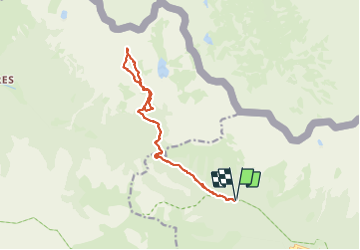
Trail Walking of 15.3 km to be discovered at Provence-Alpes-Côte d'Azur, Maritime Alps, Saint-Martin-Vésubie. This trail is proposed by bozo1970.

Description

Départ du parking été de Salèse
Col de Salèse en 45’ et 3km
Balise 269 en1h et 4km
Prendre la piste à gauche
Arrivée au lac de Graveirette en1h30’, 6km et D 600m
Montée hors sentier nord ouest jusqu’à la crête de Colombrons en 2h56’, 7km400 et D  1000m
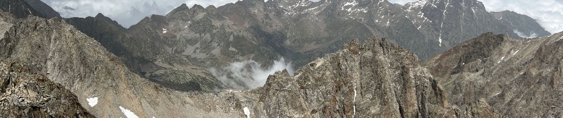
Pointe Giegn en suivant la crête en 3h50’, 8km et D  1220m
A/R en 6h23’, 15km500 et D 1248m

Elevation profile

Photos

Positioning

Country:
France
Region :
Provence-Alpes-Côte d'Azur
Department/Province :
Maritime Alps
Municipality :
Saint-Martin-Vésubie
Location:
Unknown
Start:(UTM)
360869 ; 4887343 (32T) N.

Trails nearby

Trail Walking Saint-Martin-Vésubie - Lac de Trécolpas - Photo
Walking
patsure

Walking

Medium
(2)
Saint-Martin-Vésubie, Provence-Alpes-Côte d'Azur, Maritime Alps, France
13.3 km | 20 km-effort
4h 17min
Yes
Trail Walking Saint-Martin-Vésubie - lacs bessons - Photo
Walking
REYPatrick

Walking

Very easy
(1)
Saint-Martin-Vésubie, Provence-Alpes-Côte d'Azur, Maritime Alps, France
13.1 km | 0 m-effort
7h 36min
Yes
Trail Walking Saint-Martin-Vésubie - Lac Ne`gre bis - Photo
Walking
kenhava

Walking

Medium
(1)
Saint-Martin-Vésubie, Provence-Alpes-Côte d'Azur, Maritime Alps, France
13.1 km | 23 km-effort
3h 42min
Yes
Trail On foot Saint-Martin-Vésubie - Col de Cerise - Photo
On foot
GUIDE+

On foot

Medium
Saint-Martin-Vésubie, Provence-Alpes-Côte d'Azur, Maritime Alps, France
9.7 km | 23 km-effort
5h 18min
Yes
Trail On foot Saint-Martin-Vésubie - Circuit des Adus - Photo
On foot
GUIDE+

On foot

Easy
Saint-Martin-Vésubie, Provence-Alpes-Côte d'Azur, Maritime Alps, France
9.9 km | 18.8 km-effort
4h 16min
Yes
Trail On foot Saint-Martin-Vésubie - Circuit de Trécolpas - Photo
On foot
GUIDE+

On foot

Easy
Saint-Martin-Vésubie, Provence-Alpes-Côte d'Azur, Maritime Alps, France
8.9 km | 15.8 km-effort
3h 35min
Yes
Trail On foot Valdeblore - Lac Nègre - Photo
On foot
GUIDE+

On foot

Easy
Valdeblore, Provence-Alpes-Côte d'Azur, Maritime Alps, France
11.1 km | 19.6 km-effort
4h 27min
Yes
Trail Touring skiing Saint-Martin-Vésubie - Col de cerise et lac du Mercantour - Photo
Touring skiing
GUIDE
nadd73

Touring skiing

Medium
Saint-Martin-Vésubie, Provence-Alpes-Côte d'Azur, Maritime Alps, France
11.9 km | 29 km-effort
7h 39min
Yes
Trail Touring skiing Saint-Martin-Vésubie - Baisse de Pagari de Salèse - Photo
Touring skiing
GUIDE
nadd73

Touring skiing

Difficult
Saint-Martin-Vésubie, Provence-Alpes-Côte d'Azur, Maritime Alps, France
10.5 km | 23 km-effort
6h 53min
Yes


Close
My subscriptions