Trail Walking Presles - boucle du belvédère du Ranc - Photo

boucle du belvédère du Ranc

 fafa74
fafa74

User

© OpenStreetMap contributors
Length
Length
6.9 km
Max alt
Max alt
1272 m
Uphill gradient
Uphill gradient
284 m
Km-Effort
Km-Effort  
10.7 km
Min alt
Min alt
1013 m
Downhill gradient
Downhill gradient
281 m
Boucle
Boucle
No
Creation date :
2023-05-28 08:52:06.47
Updated on :
2023-06-17 16:41:46.341

(0 Reviews)

Walking
Walking
2h23
Difficulty : Easy

Scan this QR Code to open this trail in the SityTrail application

FREE GPS app for hiking

Logo SityTrail SityTrail

IGN / Geographical institutes

Download SityTrail from the App Store Download SityTrail from Google Play

Logo SityTrail SityTrail World

The world is yours!

Download SityTrail from the App Store Download SityTrail from Google Play Download SityTrail on Huawei AppGallery

About

Trail Walking of 6.9 km to be discovered at Auvergne-Rhône-Alpes, Isère, Presles. This trail is proposed by fafa74.

Description

rando tranquille entre forêts et prairies avec magnifique belvédère sur les gorges de la Bourne et panorama sur la plaine du Rhône

Elevation profile

Positioning

Country:
France
Region :
Auvergne-Rhône-Alpes
Department/Province :
Isère
Municipality :
Presles
Location:
Unknown
Start:(UTM)
691384 ; 4994888 (31T) N.

Trails nearby

Trail Walking Châtelus - 38 bournillon porte du diable charmatte - Photo
Walking
GUIDE
randodyssée

Walking

Difficult
(1)
Châtelus, Auvergne-Rhône-Alpes, Isère, France
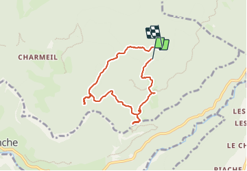
16.5 km | 34 km-effort
8h 7min
Yes
Trail Walking Châtelus - Boucle Pas de l'Allier - Pas des Voutes - Photo
Walking
tracegps

Walking

Medium
(1)
Châtelus, Auvergne-Rhône-Alpes, Isère, France
10.1 km | 22 km-effort
4h 30min
Yes
Trail Walking Châtelus - 38 pabro charmatte - Photo
Walking
GUIDE
randodyssée

Walking

Difficult
Châtelus, Auvergne-Rhône-Alpes, Isère, France
11.4 km | 29 km-effort
7h 43min
Yes
Trail Walking Rencurel - 38 vire bourne goule noire  - Photo
Walking
GUIDE
randodyssée

Walking

Medium
Rencurel, Auvergne-Rhône-Alpes, Isère, France
11.9 km | 24 km-effort
6h 44min
Yes
Trail On foot Rencurel - La Balme Noire par la vire de Haute Valette - Photo
On foot
cmarit

On foot

Difficult
(1)
Rencurel, Auvergne-Rhône-Alpes, Isère, France
10.5 km | 21 km-effort
Unknown
Yes
Trail Walking Châtelus - la grande cournouse - Photo
Walking
GUIDE
nadd73

Walking

Difficult
Châtelus, Auvergne-Rhône-Alpes, Isère, France
10.5 km | 26 km-effort
6h 34min
Yes
Trail Walking Châtelus - la grotte des Gaulois, le pas de l' Echarasson, porte du diable, pas de charmate - Photo
Walking
GUIDE
nadd73

Walking

Difficult
Châtelus, Auvergne-Rhône-Alpes, Isère, France
18.3 km | 37 km-effort
8h 23min
Yes
Trail Walking Choranche - Presles grotte de Gournier et de balme rousse - Photo
Walking
GUIDE
nadd73

Walking

Medium
Choranche, Auvergne-Rhône-Alpes, Isère, France
5.5 km | 14.6 km-effort
3h 19min
Yes
Trail Walking Choranche - La Grotte de Choranche - Photo
Walking
grfamily

Walking

Difficult
(1)
Choranche, Auvergne-Rhône-Alpes, Isère, France
17.8 km | 33 km-effort
7h 6min
Yes


Close
My subscriptions