Trail On foot Sewen - Sewen-lac d'Alfeld-Schahling Hutte - Photo

Sewen-lac d'Alfeld-Schahling Hutte

 JCLUTT
JCLUTT

User

© OpenStreetMap contributors
Length
Length
10.6 km
Max alt
Max alt
927 m
Uphill gradient
Uphill gradient
612 m
Km-Effort
Km-Effort  
18.8 km
Min alt
Min alt
494 m
Downhill gradient
Downhill gradient
613 m
Boucle
Boucle
Yes
Creation date :
2023-06-15 07:17:48.217
Updated on :
2023-06-15 07:52:51.068

(0 Reviews)

On foot
On foot
4h16
Difficulty : Easy

Scan this QR Code to open this trail in the SityTrail application

FREE GPS app for hiking

Logo SityTrail SityTrail

IGN / Geographical institutes

Download SityTrail from the App Store Download SityTrail from Google Play

Logo SityTrail SityTrail World

The world is yours!

Download SityTrail from the App Store Download SityTrail from Google Play Download SityTrail on Huawei AppGallery

About

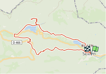
Trail On foot of 10.6 km to be discovered at Grand Est, Haut-Rhin, Sewen. This trail is proposed by JCLUTT.

Description

Circuit souvent à couvert et un peu de dénivelé !

Elevation profile

Points of interest

Point of interest Sewen - Cercle bleu-blanc - Photo
JCLUTT
Point of interest Sewen - Croisement D466 - Photo
JCLUTT
Point of interest Sewen - Cercle rouge - Photo
JCLUTT
Point of interest Sewen - Croisement D466 - Photo
JCLUTT
Point of interest Sewen - Triangle rouge - Photo
JCLUTT
Point of interest Sewen - Croisement D466 - Photo
JCLUTT

Positioning

Country:
France
Region :
Grand Est
Department/Province :
Haut-Rhin
Municipality :
Sewen
Location:
Unknown
Start:(UTM)
343184 ; 5296967 (32T) N.

Trails nearby

Trail Walking Rimbach-près-Masevaux - Haute Bers - Photo
Walking
helmut68

Walking

Medium
(1)
Rimbach-près-Masevaux, Grand Est, Haut-Rhin, France
12 km | 20 km-effort
3h 25min
Yes
Trail Walking Saint-Maurice-sur-Moselle - Tour du Ballon d'Alsace - Photo
Walking
VacheKiri67

Walking

Difficult
(1)
Saint-Maurice-sur-Moselle, Grand Est, Vosges, France
10.5 km | 17.7 km-effort
5h 25min
Yes
Trail Walking Sewen - Boucle entre les lacs de Sewen et d'Alfeld - Photo
Walking
tracegps

Walking

Medium
(1)
Sewen, Grand Est, Haut-Rhin, France
8.1 km | 12.3 km-effort
2h 30min
Yes
Trail Walking Sewen - lac d'Alfeld  - Photo
Walking
klopbill

Walking

Very difficult
(1)
Sewen, Grand Est, Haut-Rhin, France
17.1 km | 28 km-effort
8h 7min
Yes
Trail Walking Kirchberg - 2022-07-15 Marche Refuge Baerenkopf Auberge Gazon Vert - Photo
Walking
GUIDE
holtzv

Walking

Very difficult
Kirchberg, Grand Est, Haut-Rhin, France
23 km | 38 km-effort
8h 21min
No
Trail Walking Rimbach-près-Masevaux - Les deux lacs - Photo
Walking
helmut68

Walking

Difficult
Rimbach-près-Masevaux, Grand Est, Haut-Rhin, France
15.5 km | 25 km-effort
5h 47min
Yes
Trail Walking Wegscheid - FucksfelsenBelacker - Photo
Walking
helmut68

Walking

Medium
Wegscheid, Grand Est, Haut-Rhin, France
14.4 km | 24 km-effort
4h 9min
Yes
Trail Walking Wegscheid - Sattelboden Stahlberg - Photo
Walking
helmut68

Walking

Very difficult
Wegscheid, Grand Est, Haut-Rhin, France
11.9 km | 20 km-effort
4h 35min
Yes
Trail Walking Wegscheid - Sortie école primaire - Rossberg - Photo
Walking
helmut68

Walking

Medium
Wegscheid, Grand Est, Haut-Rhin, France
11.8 km | 19.1 km-effort
4h 48min
Yes


Close
My subscriptions