![](/images/other/stat-length.png)
Pain de Sucre 400m+ depuis le col Agnel
ericberlin
User
![Length](/images/other/stat-length.png)
Length
4.2 km
![Max alt](https://static1.geolcdn.com/siteimages/upload/files/1508320355ic_sort_altitude_max_24dp.png)
Max alt
3145 m
![Uphill gradient](https://static1.geolcdn.com/siteimages/upload/files/1508320355ic_sort_den_pos_24dp.png)
Uphill gradient
400 m
![Km-Effort](/images/other/stat-length.png)
Km-Effort
9.6 km
![Min alt](https://static1.geolcdn.com/siteimages/upload/files/1508320355ic_sort_altitude_min_24dp.png)
Min alt
2738 m
![Downhill gradient](https://static1.geolcdn.com/siteimages/upload/files/1508320355ic_sort_den_neg_24dp.png)
Downhill gradient
400 m
![Boucle](https://static1.geolcdn.com/siteimages/upload/files/16400158638029165_repeat_loop_refresh_sync_direction_icon.png)
Boucle
Yes
Creation date :
2023-06-14 14:55:56.636
Updated on :
2023-06-14 15:04:00.457
![Walking](https://static1.geolcdn.com/sitytour/trail-icons/101.png)
2h10
Difficulty : Medium
![Scan this QR Code to open this trail in the SityTrail application](https://capi.geolives.com/qq0zvz2zws4bq2lad0pu/sitytour/trails/3699253/qr.png?size=200)
FREE GPS app for hiking
About
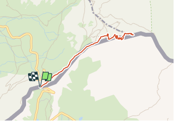
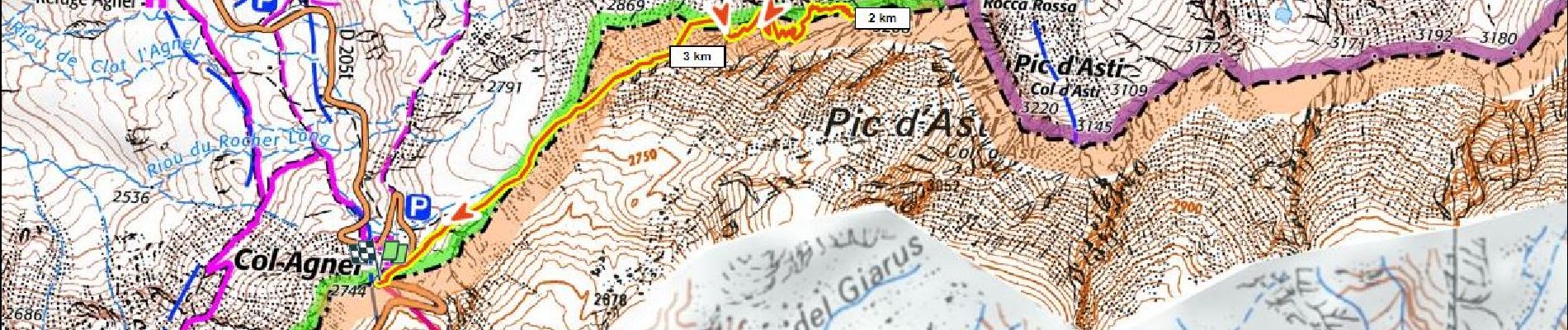
Trail Walking of 4.2 km to be discovered at Piemont, Cuneo, Pontechianale. This trail is proposed by ericberlin.
Description
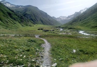
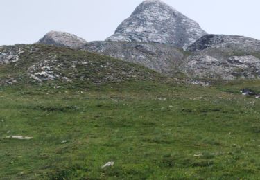
Un "3000" facile mais attention aux conditions de haute montagne, neige au début de l'été, orages fréquents après 11h.
Un panorama à decouvrir au lever du soleil.
Refuge Agnel à proximité du départ
Positioning
Country:
Italy
Region :
Piemont
Department/Province :
Cuneo
Municipality :
Pontechianale
Location:
Unknown
Start:(Dec)
Start:(UTM)
339864 ; 4949812 (32T) N.
Comments
Trails nearby
![Trail Walking Saint-Véran - Lac de la Blanche, lacs blanchet et pic de Caramantran - Photo](https://media.geolcdn.com/t/375/260/ext.jpg?maxdim=2&url=https%3A%2F%2Fservices.sitytrail.com%2FGeolivesWS%2FDownloadMedia.ashx%3FTrailID%3D596077%26Media%3Dfix__20160710142025.jpg)
![Walking Walking](https://static1.geolcdn.com/sitytour/trail-icons/101.png)
Lac de la Blanche, lacs blanchet et pic de Caramantran
Walking
Medium
(2)
Saint-Véran,
Provence-Alpes-Côte d'Azur,
Hautes-Alpes,
France
![](/images/other/stat-length.png)
13.1 km | 23 km-effort
6h 12min
![](https://static1.geolcdn.com/siteimages/upload/files/16400158638029165_repeat_loop_refresh_sync_direction_icon.png)
Yes
![Trail Walking Pontechianale - ITALIE BELLINO CHIANALE . TOUR DU PAIN DU SUCRE . AR. O - Photo](https://media.geolcdn.com/t/375/260/605ee47c-e413-41ea-82a5-10806d48b77c.jpg&format=jpg&maxdim=2)
![Walking Walking](https://static1.geolcdn.com/sitytour/trail-icons/101.png)
ITALIE BELLINO CHIANALE . TOUR DU PAIN DU SUCRE . AR. O
Walking
Medium
Pontechianale,
Piemont,
Cuneo,
Italy
![](/images/other/stat-length.png)
7.7 km | 11.3 km-effort
2h 36min
![](https://static1.geolcdn.com/siteimages/upload/files/16400158638029165_repeat_loop_refresh_sync_direction_icon.png)
Yes
![Trail Walking Molines-en-Queyras - le tour du Pain de Sucre - Photo](https://media.geolcdn.com/t/375/260/ext.jpg?maxdim=2&url=https%3A%2F%2Fservices.sitytrail.com%2FGeolivesWS%2FDownloadMedia.ashx%3FTrailID%3D820382%26Media%3Dfix__20170830144825.jpg)
![Walking Walking](https://static1.geolcdn.com/sitytour/trail-icons/101.png)
le tour du Pain de Sucre
Walking
Difficult
Molines-en-Queyras,
Provence-Alpes-Côte d'Azur,
Hautes-Alpes,
France
![](/images/other/stat-length.png)
8.1 km | 16 km-effort
4h 57min
![](https://static1.geolcdn.com/siteimages/upload/files/16400158638029165_repeat_loop_refresh_sync_direction_icon.png)
Yes
![Trail Walking Saint-Véran - Pic de Caramantran - Photo](https://media.geolcdn.com/t/375/260/ext.jpg?maxdim=2&url=https%3A%2F%2Fservices.sitytrail.com%2FGeolivesWS%2FDownloadMedia.ashx%3FTrailID%3D629317%26Media%3D93967439-727d-490c-bf0f-c5937248e7c8.jpg)
![Walking Walking](https://static1.geolcdn.com/sitytour/trail-icons/101.png)
Pic de Caramantran
Walking
Very difficult
Saint-Véran,
Provence-Alpes-Côte d'Azur,
Hautes-Alpes,
France
![](/images/other/stat-length.png)
12 km | 23 km-effort
4h 41min
![](https://static1.geolcdn.com/siteimages/upload/files/16400158638029165_repeat_loop_refresh_sync_direction_icon.png)
Yes
![Trail Walking Molines-en-Queyras - Lacs Foréant, Egorgéou, Baricle et de l'Eychassier - Photo](https://media.geolcdn.com/t/375/260/ext.jpg?maxdim=2&url=https%3A%2F%2Fservices.sitytrail.com%2FGeolivesWS%2FDownloadMedia.ashx%3FTrailID%3D597581%26Media%3Dfix__20160713160454.jpg)
![Walking Walking](https://static1.geolcdn.com/sitytour/trail-icons/101.png)
Lacs Foréant, Egorgéou, Baricle et de l'Eychassier
Walking
Medium
Molines-en-Queyras,
Provence-Alpes-Côte d'Azur,
Hautes-Alpes,
France
![](/images/other/stat-length.png)
13.8 km | 24 km-effort
6h 20min
![](https://static1.geolcdn.com/siteimages/upload/files/16400158638029165_repeat_loop_refresh_sync_direction_icon.png)
Yes
![Trail Walking Molines-en-Queyras - le pain de sucre - Photo](https://media.geolcdn.com/t/375/260/ext.jpg?maxdim=2&url=https%3A%2F%2Fservices.sitytrail.com%2FGeolivesWS%2FDownloadMedia.ashx%3FTrailID%3D444362%26Media%3Dfix__20150712140232.jpg)
![Walking Walking](https://static1.geolcdn.com/sitytour/trail-icons/101.png)
le pain de sucre
Walking
Difficult
(1)
Molines-en-Queyras,
Provence-Alpes-Côte d'Azur,
Hautes-Alpes,
France
![](/images/other/stat-length.png)
4.5 km | 10.1 km-effort
4h 39min
![](https://static1.geolcdn.com/siteimages/upload/files/16400158638029165_repeat_loop_refresh_sync_direction_icon.png)
Yes
![Trail Walking Pontechianale - pain de sucre circuit - Photo](https://media.geolcdn.com/t/375/260/765c798f-47ae-4e08-a9cf-50bd35561578.jpg&format=jpg&maxdim=2)
![Walking Walking](https://static1.geolcdn.com/sitytour/trail-icons/101.png)
pain de sucre circuit
Walking
Medium
Pontechianale,
Piemont,
Cuneo,
Italy
![](/images/other/stat-length.png)
5.9 km | 11.9 km-effort
2h 12min
![](https://static1.geolcdn.com/siteimages/upload/files/16400158638029165_repeat_loop_refresh_sync_direction_icon.png)
No
![Trail Walking Molines-en-Queyras - Pic Foréant et Col d'Asti - Photo](https://media.geolcdn.com/t/375/260/0a0f75bf-b7eb-4c17-be04-8e1330cfc2d9.jpg&format=jpg&maxdim=2)
![Walking Walking](https://static1.geolcdn.com/sitytour/trail-icons/101.png)
Pic Foréant et Col d'Asti
Walking
Very difficult
Molines-en-Queyras,
Provence-Alpes-Côte d'Azur,
Hautes-Alpes,
France
![](/images/other/stat-length.png)
11.8 km | 24 km-effort
7h 14min
![](https://static1.geolcdn.com/siteimages/upload/files/16400158638029165_repeat_loop_refresh_sync_direction_icon.png)
No
![Trail Walking Molines-en-Queyras - 05-Pain-de-sucre-6.5km-525m-aout21 - Photo](https://media.geolcdn.com/t/375/260/7e381716-a2f4-4b1d-8463-85a8f85532fe.jpg&format=jpg&maxdim=2)
![Walking Walking](https://static1.geolcdn.com/sitytour/trail-icons/101.png)
05-Pain-de-sucre-6.5km-525m-aout21
Walking
Medium
Molines-en-Queyras,
Provence-Alpes-Côte d'Azur,
Hautes-Alpes,
France
![](/images/other/stat-length.png)
6.5 km | 13.5 km-effort
4h 14min
![](https://static1.geolcdn.com/siteimages/upload/files/16400158638029165_repeat_loop_refresh_sync_direction_icon.png)
Yes