Trail Walking Mayrinhac-Lentour - Le marais de Bonnefond  - Photo

Le marais de Bonnefond

 Gegetop
Gegetop

User

© OpenStreetMap contributors
Length
Length
2.1 km
Max alt
Max alt
339 m
Uphill gradient
Uphill gradient
20 m
Km-Effort
Km-Effort  
2.3 km
Min alt
Min alt
321 m
Downhill gradient
Downhill gradient
20 m
Boucle
Boucle
Yes
Creation date :
2023-06-01 12:28:38.529
Updated on :
2023-06-01 13:37:44.648

(0 Reviews)

Walking
Walking
1h07
Difficulty : Easy

Scan this QR Code to open this trail in the SityTrail application

FREE GPS app for hiking

Logo SityTrail SityTrail

IGN / Geographical institutes

Download SityTrail from the App Store Download SityTrail from Google Play

Logo SityTrail SityTrail World

The world is yours!

Download SityTrail from the App Store Download SityTrail from Google Play Download SityTrail on Huawei AppGallery

About

Trail Walking of 2.1 km to be discovered at Occitania, Lot, Mayrinhac-Lentour. This trail is proposed by Gegetop.

Description

Petit circuit aménagé qui vous fera découvrir la vie dans les milieux humides.

Elevation profile

Photos

Positioning

Country:
France
Region :
Occitania
Department/Province :
Lot
Municipality :
Mayrinhac-Lentour
Location:
Unknown
Start:(UTM)
405038 ; 4963636 (31T) N.

Trails nearby

Trail On foot Saint-Jean-Lespinasse - St Jean Lespinasse - La Césarine - Photo
On foot
PRO

On foot

Easy
Saint-Jean-Lespinasse, Occitania, Lot, France
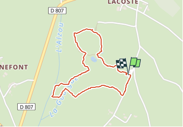
3.8 km | 5.9 km-effort
1h 20min
Yes
Trail Walking Loubressac - autoire cascade siran - Photo
Walking
Forsans

Walking

Medium
Loubressac, Occitania, Lot, France
5.5 km | 8.4 km-effort
1h 55min
No
Trail Walking Autoire - Autoire - Loubressac - Photo
Walking
neitag61

Walking

Medium
Autoire, Occitania, Lot, France
10.4 km | 15.1 km-effort
3h 9min
Yes
Trail Walking Autoire - Le cirque d'Autoire - Photo
Walking
sdroneau

Walking

Medium
Autoire, Occitania, Lot, France
16 km | 22 km-effort
3h 40min
Yes
Trail sport Padirac - Dordogne - Photo
sport
jlmauriz

sport

Very easy
Padirac, Occitania, Lot, France
15.7 km | 22 km-effort
Unknown
No
Trail Walking Thégra - Thégra - Circuit des fontaines - Photo
Walking
houbart

Walking

Difficult
(1)
Thégra, Occitania, Lot, France
11.5 km | 14.4 km-effort
3h 10min
Yes
Trail Walking Autoire - Autoire Loubressac Gouffre de Padirac - Photo
Walking
Gaillard Isabelle

Walking

Difficult
Autoire, Occitania, Lot, France
20 km | 28 km-effort
7h 2min
Yes
Trail Walking Autoire - Autoire lot Of sports - Photo
Walking
cps46

Walking

Autoire, Occitania, Lot, France
14.7 km | 21 km-effort
5h 25min
Yes
Trail Walking Saignes - saigne - Photo
Walking
marmotte64

Walking

Easy
Saignes, Occitania, Lot, France
11.1 km | 14.3 km-effort
2h 56min
Yes


Close
My subscriptions