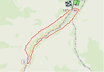
![](/images/other/stat-length.png)
![Trail Walking Beaudéan - Vallée de Lesponne et cascade de Magenta. - Photo](https://media.geolcdn.com/t/1900/400/ext.pjpeg?maxdim=2&url=https%3A%2F%2Fstatic1.geolcdn.com%2Fsiteimages%2Fupload%2Ffiles%2F1553511878bg_sport_marche.png)
Vallée de Lesponne et cascade de Magenta.
Santblasi
User
![Length](/images/other/stat-length.png)
Length
8.7 km
![Max alt](https://static1.geolcdn.com/siteimages/upload/files/1508320355ic_sort_altitude_max_24dp.png)
Max alt
1003 m
![Uphill gradient](https://static1.geolcdn.com/siteimages/upload/files/1508320355ic_sort_den_pos_24dp.png)
Uphill gradient
301 m
![Km-Effort](/images/other/stat-length.png)
Km-Effort
12.7 km
![Min alt](https://static1.geolcdn.com/siteimages/upload/files/1508320355ic_sort_altitude_min_24dp.png)
Min alt
743 m
![Downhill gradient](https://static1.geolcdn.com/siteimages/upload/files/1508320355ic_sort_den_neg_24dp.png)
Downhill gradient
297 m
![Boucle](https://static1.geolcdn.com/siteimages/upload/files/16400158638029165_repeat_loop_refresh_sync_direction_icon.png)
Boucle
Yes
Creation date :
2023-06-01 07:18:42.447
Updated on :
2023-06-01 13:07:29.882
![Walking](https://static1.geolcdn.com/sitytour/trail-icons/101.png)
4h05
Difficulty : Medium
![Scan this QR Code to open this trail in the SityTrail application](https://capi.geolives.com/qq0zvz2zws4bq2lad0pu/sitytour/trails/3683419/qr.png?size=200)
FREE GPS app for hiking
About
Trail Walking of 8.7 km to be discovered at Occitania, Hautespyrenees, Beaudéan. This trail is proposed by Santblasi.
Description
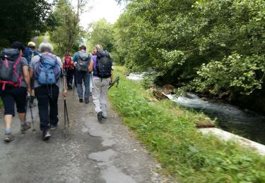
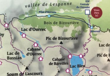
Départ parking de L'Essonne.
Suivre marquage jaune et panneaux.
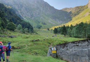
Traversée de la rivière, montée en forêt tranquille jusqu'à la passerelle de la cascade.
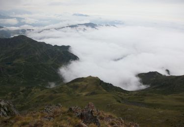
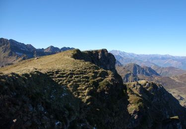
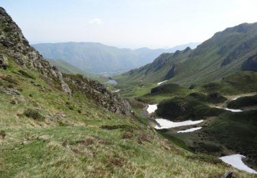
Deuxième partie, en boucle, beaucoup plus technique (ravins, cascades, pierres glissantes,....).
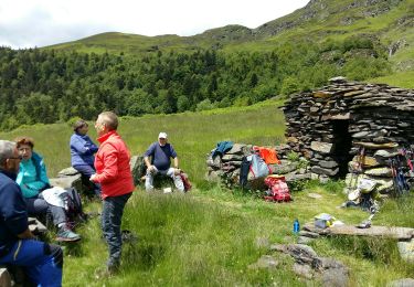
belle randonnée
Positioning
Country:
France
Region :
Occitania
Department/Province :
Hautespyrenees
Municipality :
Beaudéan
Location:
Unknown
Start:(Dec)
Start:(UTM)
266804 ; 4765526 (31T) N.
Comments
Trails nearby
![Trail Walking Bagnères-de-Bigorre - Le pic de Montaigu - Photo](https://media.geolcdn.com/t/375/260/ext.jpg?maxdim=2&url=https%3A%2F%2Fservices.sitytrail.com%2FGeolivesWS%2FDownloadMedia.ashx%3FTrailID%3D105593%26Media%3D9362_6.jpg)
![Walking Walking](https://static1.geolcdn.com/sitytour/trail-icons/101.png)
Le pic de Montaigu
Walking
Difficult
(1)
Bagnères-de-Bigorre,
Occitania,
Hautespyrenees,
France
![](/images/other/stat-length.png)
9 km | 25 km-effort
6h 0min
![](https://static1.geolcdn.com/siteimages/upload/files/16400158638029165_repeat_loop_refresh_sync_direction_icon.png)
Yes
![Trail Walking Bagnères-de-Bigorre - Lac Bleu et pic de Bizourtère (2311m) - Photo](https://media.geolcdn.com/t/375/260/ext.jpg?maxdim=2&url=https%3A%2F%2Fservices.sitytrail.com%2FGeolivesWS%2FDownloadMedia.ashx%3FTrailID%3D109966%26Media%3D5045_1.jpg)
![Walking Walking](https://static1.geolcdn.com/sitytour/trail-icons/101.png)
Lac Bleu et pic de Bizourtère (2311m)
Walking
Difficult
(1)
Bagnères-de-Bigorre,
Occitania,
Hautespyrenees,
France
![](/images/other/stat-length.png)
15 km | 32 km-effort
5h 0min
![](https://static1.geolcdn.com/siteimages/upload/files/16400158638029165_repeat_loop_refresh_sync_direction_icon.png)
Yes
![Trail Walking Beaudéan - LESPONNE entre torrents et cascades (G3) fait le 17 Juillet 2020](https://media.geolcdn.com/t/375/260/e61486eb-19e7-488b-bc78-39d6109d1c0c.jpg&format=jpg&maxdim=2)
![Walking Walking](https://static1.geolcdn.com/sitytour/trail-icons/101.png)
LESPONNE entre torrents et cascades (G3) fait le 17 Juillet 2020"2479379"
Walking
Very easy
Beaudéan,
Occitania,
Hautespyrenees,
France
![](/images/other/stat-length.png)
8.8 km | 12.9 km-effort
4h 30min
![](https://static1.geolcdn.com/siteimages/upload/files/16400158638029165_repeat_loop_refresh_sync_direction_icon.png)
Yes
![Trail Walking Bagnères-de-Bigorre - LESPONNE courtaou de la lit G3 B fait le 12/06/2020 - Photo](https://media.geolcdn.com/t/375/260/4992e91a-d5e6-4bdf-b8d5-1942787e9e14.jpg&format=jpg&maxdim=2)
![Walking Walking](https://static1.geolcdn.com/sitytour/trail-icons/101.png)
LESPONNE courtaou de la lit G3 B fait le 12/06/2020
Walking
Medium
Bagnères-de-Bigorre,
Occitania,
Hautespyrenees,
France
![](/images/other/stat-length.png)
6.2 km | 12.1 km-effort
4h 28min
![](https://static1.geolcdn.com/siteimages/upload/files/16400158638029165_repeat_loop_refresh_sync_direction_icon.png)
Yes
![Trail Walking Bagnères-de-Bigorre - Le lac bleu et le lac outrec - Photo](https://media.geolcdn.com/t/375/260/9bb915d4-d98b-4d7b-8268-4bf841ab3648.jpg&format=jpg&maxdim=2)
![Walking Walking](https://static1.geolcdn.com/sitytour/trail-icons/101.png)
Le lac bleu et le lac outrec
Walking
Very difficult
Bagnères-de-Bigorre,
Occitania,
Hautespyrenees,
France
![](/images/other/stat-length.png)
28 km | 65 km-effort
7h 13min
![](https://static1.geolcdn.com/siteimages/upload/files/16400158638029165_repeat_loop_refresh_sync_direction_icon.png)
No
![Trail Road bike Beaudéan - hourquette - Photo](https://media.geolcdn.com/t/375/260/ext.jpg?maxdim=2&url=https%3A%2F%2Fstatic1.geolcdn.com%2Fsiteimages%2Fupload%2Ffiles%2F1524743154velo.jpg)
![Road bike Road bike](https://static1.geolcdn.com/sitytour/trail-icons/201.png)
hourquette
Road bike
Very difficult
(1)
Beaudéan,
Occitania,
Hautespyrenees,
France
![](/images/other/stat-length.png)
50 km | 65 km-effort
2h 54min
![](https://static1.geolcdn.com/siteimages/upload/files/16400158638029165_repeat_loop_refresh_sync_direction_icon.png)
Yes
![Trail Walking Bagnères-de-Bigorre - etg bleu-col de bareille-pic bizoutère-lac d'Ourec depuis le Chiroulet - Photo](https://media.geolcdn.com/t/375/260/20e9c13b-1617-4d8b-b37e-de95ee0ebc15.jpg&format=jpg&maxdim=2)
![Walking Walking](https://static1.geolcdn.com/sitytour/trail-icons/101.png)
etg bleu-col de bareille-pic bizoutère-lac d'Ourec depuis le Chiroulet
Walking
Medium
Bagnères-de-Bigorre,
Occitania,
Hautespyrenees,
France
![](/images/other/stat-length.png)
16 km | 33 km-effort
7h 42min
![](https://static1.geolcdn.com/siteimages/upload/files/16400158638029165_repeat_loop_refresh_sync_direction_icon.png)
Yes
![Trail Walking Bagnères-de-Bigorre - Le montaigu - Photo](https://media.geolcdn.com/t/375/260/0d2a2a6a-e1bd-4469-8cd9-e542097178ef.jpg&format=jpg&maxdim=2)
![Walking Walking](https://static1.geolcdn.com/sitytour/trail-icons/101.png)
Le montaigu
Walking
Difficult
Bagnères-de-Bigorre,
Occitania,
Hautespyrenees,
France
![](/images/other/stat-length.png)
9.3 km | 25 km-effort
7h 41min
![](https://static1.geolcdn.com/siteimages/upload/files/16400158638029165_repeat_loop_refresh_sync_direction_icon.png)
Yes
![Trail Walking Campan - Le Lac de l''OEuf depuis le col de la Courade - Photo](https://media.geolcdn.com/t/375/260/ext.jpg?maxdim=2&url=https%3A%2F%2Fservices.sitytrail.com%2FGeolivesWS%2FDownloadMedia.ashx%3FTrailID%3D215286%26Media%3D15686_5.jpg)
![Walking Walking](https://static1.geolcdn.com/sitytour/trail-icons/101.png)
Le Lac de l''OEuf depuis le col de la Courade
Walking
Difficult
Campan,
Occitania,
Hautespyrenees,
France
![](/images/other/stat-length.png)
13.6 km | 26 km-effort
7h 0min
![](https://static1.geolcdn.com/siteimages/upload/files/16400158638029165_repeat_loop_refresh_sync_direction_icon.png)
Yes