Trail Walking Saint-Benoît-d'Hébertot - Autour du Chateau - Photo
 Marlil
Marlil

User

© OpenStreetMap contributors
Length
Length
9.5 km
Max alt
Max alt
145 m
Uphill gradient
Uphill gradient
193 m
Km-Effort
Km-Effort  
12.1 km
Min alt
Min alt
70 m
Downhill gradient
Downhill gradient
194 m
Boucle
Boucle
Yes
Creation date :
2023-06-01 07:26:41.454
Updated on :
2023-06-01 09:01:17.799

(0 Reviews)

Walking
Walking
1h33
Difficulty : Medium

Scan this QR Code to open this trail in the SityTrail application

FREE GPS app for hiking

Logo SityTrail SityTrail

IGN / Geographical institutes

Download SityTrail from the App Store Download SityTrail from Google Play

Logo SityTrail SityTrail World

The world is yours!

Download SityTrail from the App Store Download SityTrail from Google Play Download SityTrail on Huawei AppGallery

About

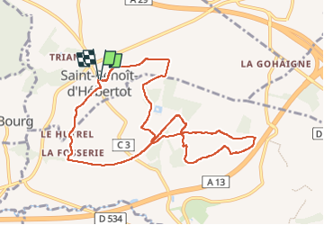
Trail Walking of 9.5 km to be discovered at Normandy, Calvados, Saint-Benoît-d'Hébertot. This trail is proposed by Marlil.

Description

A Saint Andre d'Hebertot
14300

Elevation profile

Positioning

Country:
France
Region :
Normandy
Department/Province :
Calvados
Municipality :
Saint-Benoît-d'Hébertot
Location:
Unknown
Start:(UTM)
301610 ; 5466290 (31U) N.

Trails nearby

Trail Walking Saint-André-d'Hébertot - HONFLEUR 01 - Autour du Château de Saint-André d'Hébertot - NORMANDIE - Photo
Walking
GUIDE
Michel1963

Walking

Medium
Saint-André-d'Hébertot, Normandy, Calvados, France
10.1 km | 12.7 km-effort
2h 30min
Yes
Trail On foot Le Theil-en-Auge - La Vallée de l'Orange - Photo
On foot
GUIDE+

On foot

Easy
Le Theil-en-Auge, Normandy, Calvados, France
3.5 km | 3.8 km-effort
52min
No
Trail Mountain bike Fourneville - Rando Fourneville Calvados Normandie - Photo
Mountain bike
tracegps

Mountain bike

Difficult
Fourneville, Normandy, Calvados, France
26 km | 32 km-effort
2h 40min
Yes
Trail Walking Fourneville - Rando Fourneville Calvados Normandie - Photo
Walking
tracegps

Walking

Very difficult
Fourneville, Normandy, Calvados, France
26 km | 32 km-effort
5h 0min
Yes
Trail Walking Vieux-Bourg - Vieux Bourg - Photo
Walking
Eve - Line

Walking

Medium
(1)
Vieux-Bourg, Normandy, Calvados, France
12.3 km | 15.8 km-effort
3h 10min
Yes
Trail Mountain bike Saint-Julien-sur-Calonne - De St Julien sur Calonne à Fierville les Parcs - Photo
Mountain bike
tracegps

Mountain bike

Difficult
Saint-Julien-sur-Calonne, Normandy, Calvados, France
23 km | 28 km-effort
2h 0min
Yes
Trail On foot Fourneville - FOURNEVILLE 2 - Photo
On foot
lensois

On foot

Easy
Fourneville, Normandy, Calvados, France
8.8 km | 10.1 km-effort
2h 18min
Yes
Trail On foot Fourneville - FOURNEVILLE 1 - Photo
On foot
lensois

On foot

Easy
Fourneville, Normandy, Calvados, France
12.2 km | 15.6 km-effort
3h 32min
Yes
Trail Electric bike Saint-Gatien-des-Bois - Pont l évêque Deauville jongleur - Photo
Electric bike
yves62410

Electric bike

Medium
Saint-Gatien-des-Bois, Normandy, Calvados, France
56 km | 64 km-effort
3h 30min
Yes


Close
My subscriptions