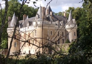
Trail Walking Luché-Pringé - Chemin du bord de Loir vers le château de Gallerande et Pringé - Photo

Chemin du bord de Loir vers le château de Gallerande et Pringé

 LANDRIEU
LANDRIEU

User

© OpenStreetMap contributors
Length
Length
10.4 km
Max alt
Max alt
84 m
Uphill gradient
Uphill gradient
97 m
Km-Effort
Km-Effort  
11.7 km
Min alt
Min alt
27 m
Downhill gradient
Downhill gradient
95 m
Boucle
Boucle
Yes
Creation date :
2023-06-01 04:25:46.81
Updated on :
2023-06-01 04:26:40.315

(0 Reviews)

Walking
Walking
2h39
Difficulty : Medium

Scan this QR Code to open this trail in the SityTrail application

FREE GPS app for hiking

Logo SityTrail SityTrail

IGN / Geographical institutes

Download SityTrail from the App Store Download SityTrail from Google Play

Logo SityTrail SityTrail World

The world is yours!

Download SityTrail from the App Store Download SityTrail from Google Play Download SityTrail on Huawei AppGallery

About

Trail Walking of 10.4 km to be discovered at Pays de la Loire, Sarthe, Luché-Pringé. This trail is proposed by LANDRIEU.

Elevation profile

Points of interest

Point of interest Luché-Pringé - Place des Tilleuls - Photo
LANDRIEU
LUCHÉ-PRINGÉ 
Point of interest Luché-Pringé - Bord du - Photo
LANDRIEU
LUCHÉ-PRINGÉ 
Point of interest Luché-Pringé - Banc et panneau d'information sur le moulin - Photo
LANDRIEU
Point of interest Luché-Pringé - Bifurcation à droite - Photo
LANDRIEU
LUCHÉ-PRINGÉ 
Point of interest Luché-Pringé - Bifurcation à droite - Photo
LANDRIEU
LUCHÉ-PRINGÉ 
Point of interest Luché-Pringé - Carrefour avec la D13 - Photo
LANDRIEU
LUCHÉ-PRINGÉ 
Point of interest Luché-Pringé - Chemin privé autorisé aux randonneurs - Photo
LANDRIEU
Point of interest Luché-Pringé - D13 - Photo
LANDRIEU
LUCHÉ-PRINGÉ 
Point of interest Luché-Pringé - La Croix Robert - Photo
LANDRIEU
LUCHÉ-PRINGÉ 
Point of interest Luché-Pringé - Bifurcation vers la D13 - Photo
LANDRIEU
LUCHÉ-PRINGÉ 
Point of interest Luché-Pringé - Ouverture dans la haie - Photo
LANDRIEU
LUCHÉ-PRINGÉ 
Point of interest Luché-Pringé - Jonction D54 - Photo
LANDRIEU
LUCHÉ-PRINGÉ 
Point of interest Luché-Pringé - Place des Tilleuls - Photo
LANDRIEU
LUCHÉ-PRINGÉ 

Positioning

Country:
France
Region :
Pays de la Loire
Department/Province :
Sarthe
Municipality :
Luché-Pringé
Location:
Unknown
Start:(UTM)
280510 ; 5287368 (31T) N.

Trails nearby

Trail On foot Saint-Jean-de-la-Motte - Sentier de la Mare aux Cochons - Photo
On foot
GUIDE+

On foot

Easy
Saint-Jean-de-la-Motte, Pays de la Loire, Sarthe, France
5.7 km | 7.3 km-effort
1h 39min
No
Trail On foot Saint-Jean-de-la-Motte - Sentier du Château de Gallerande - Photo
On foot
GUIDE+

On foot

Easy
Saint-Jean-de-la-Motte, Pays de la Loire, Sarthe, France
3.2 km | 4 km-effort
54min
No
Trail On foot Luché-Pringé - Luché Pringé 72 - Photo
On foot
Jos17

On foot

Very easy
Luché-Pringé, Pays de la Loire, Sarthe, France
9.1 km | 9.9 km-effort
Unknown
Yes
Trail Mountain bike Luché-Pringé - bordduloiretgallerande - Photo
Mountain bike
leroygibbs

Mountain bike

Easy
Luché-Pringé, Pays de la Loire, Sarthe, France
10.6 km | 12.2 km-effort
50min
Yes
Trail Walking Le Lude - 2019-08-18 - Photo
Walking
jcrespel

Walking

Medium
Le Lude, Pays de la Loire, Sarthe, France
10.9 km | 12.6 km-effort
2h 58min
No
Trail Walking Thorée-les-Pins - 2019-08-16 jour 5 - Photo
Walking
jcrespel

Walking

Medium
Thorée-les-Pins, Pays de la Loire, Sarthe, France
9 km | 10.2 km-effort
2h 45min
No
Trail Walking Thorée-les-Pins - Bois de Mervé - Photo
Walking
monted4460

Walking

Very easy
Thorée-les-Pins, Pays de la Loire, Sarthe, France
24 km | 27 km-effort
5h 57min
Yes


Close
My subscriptions