Trail Walking Saint-Antonin-sur-Bayon - Refuge Beaudino Sainte Victoire 825m D+300m - Photo

Refuge Beaudino Sainte Victoire 825m D+300m

© OpenStreetMap contributors
Length
Length
3.8 km
Max alt
Max alt
824 m
Uphill gradient
Uphill gradient
299 m
Km-Effort
Km-Effort  
7.7 km
Min alt
Min alt
506 m
Downhill gradient
Downhill gradient
299 m
Boucle
Boucle
Yes
Creation date :
2023-05-29 14:13:25.581
Updated on :
2023-06-05 13:34:36.398

(0 Reviews)

Walking
Walking
1h45
Difficulty : Medium

Scan this QR Code to open this trail in the SityTrail application

FREE GPS app for hiking

Logo SityTrail SityTrail

IGN / Geographical institutes

Download SityTrail from the App Store Download SityTrail from Google Play

Logo SityTrail SityTrail World

The world is yours!

Download SityTrail from the App Store Download SityTrail from Google Play Download SityTrail on Huawei AppGallery

About

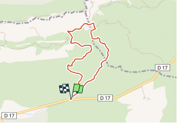
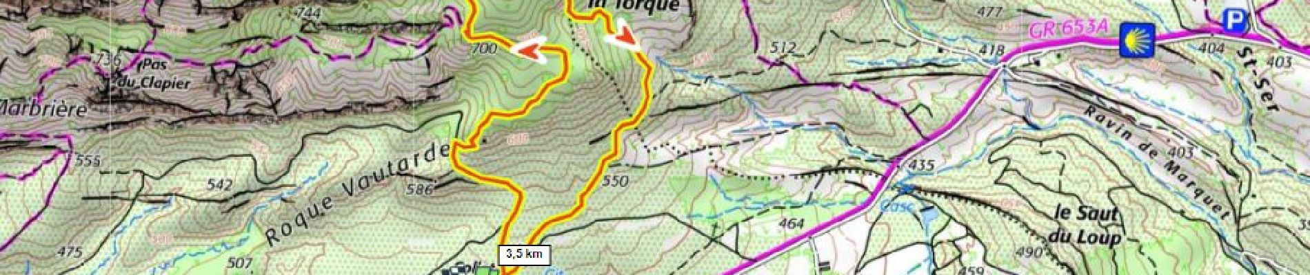
Trail Walking of 3.8 km to be discovered at Provence-Alpes-Côte d'Azur, Bouches-du-Rhône, Saint-Antonin-sur-Bayon. This trail is proposed by ericberlin.

Description

https://www.refuges.info/point/2212/
rando facile sur versant sud de la Sainte Victoire, à éviter par temps chaud.
L'été, consulter systématiquement la carte des conditions d’accès au massifs forestiers dans le 13 en fonction du risque d’incendie.
http://bpatp.paca-ate.fr/
ou téléphoner au 0811 20 13 13

Elevation profile

Photos

Positioning

Country:
France
Region :
Provence-Alpes-Côte d'Azur
Department/Province :
Bouches-du-Rhône
Municipality :
Saint-Antonin-sur-Bayon
Location:
Unknown
Start:(UTM)
711424 ; 4821961 (31T) N.

Trails nearby

Trail Walking Saint-Antonin-sur-Bayon - Ste Victoire - Le Garagaï - Photo
Walking
ETMU5496

Walking

Difficult
(1)
Saint-Antonin-sur-Bayon, Provence-Alpes-Côte d'Azur, Bouches-du-Rhône, France
15.8 km | 28 km-effort
4h 36min
Yes
Trail Walking Vauvenargues - Le Signal, Montagne Sainte-Victoire - Photo
Walking
tracegps

Walking

Medium
(2)
Vauvenargues, Provence-Alpes-Côte d'Azur, Bouches-du-Rhône, France
15 km | 25 km-effort
6h 19min
Yes
Trail Walking Saint-Antonin-sur-Bayon - 2023-02-10 Sainte Victoire Bau des Vespres - Photo
Walking
GUIDE
Kargil

Walking

Difficult
Saint-Antonin-sur-Bayon, Provence-Alpes-Côte d'Azur, Bouches-du-Rhône, France
10 km | 18.8 km-effort
3h 30min
Yes
Trail Walking Puyloubier - 2023-02-03 Sainte Victoire - Le Pic des Mouches - Photo
Walking
GUIDE
Kargil

Walking

Difficult
Puyloubier, Provence-Alpes-Côte d'Azur, Bouches-du-Rhône, France
10 km | 19 km-effort
3h 10min
Yes
Trail On foot Vauvenargues - Sentier des Venturiers - Photo
On foot
GUIDE+

On foot

Easy
Vauvenargues, Provence-Alpes-Côte d'Azur, Bouches-du-Rhône, France
5 km | 10.5 km-effort
2h 23min
No
Trail Walking Saint-Antonin-sur-Bayon - le Garagai, signal  - Photo
Walking
GUIDE
nadd73

Walking

Difficult
Saint-Antonin-sur-Bayon, Provence-Alpes-Côte d'Azur, Bouches-du-Rhône, France
6.8 km | 14.1 km-effort
3h 38min
Yes
Trail Walking Saint-Antonin-sur-Bayon - la croix de Provence - Photo
Walking
GUIDE
nadd73

Walking

Difficult
Saint-Antonin-sur-Bayon, Provence-Alpes-Côte d'Azur, Bouches-du-Rhône, France
6.6 km | 14.7 km-effort
5h 11min
Yes
Trail Walking Puyloubier - Pic dès mouches puyloubier - Photo
Walking
GUIDE
nadd73

Walking

Easy
Puyloubier, Provence-Alpes-Côte d'Azur, Bouches-du-Rhône, France
6.8 km | 15.2 km-effort
4h 52min
Yes
Trail Walking Saint-Antonin-sur-Bayon - pas du clapier et tracé vert - Photo
Walking
GUIDE
amiral13

Walking

Difficult
Saint-Antonin-sur-Bayon, Provence-Alpes-Côte d'Azur, Bouches-du-Rhône, France
10.5 km | 21 km-effort
5h 24min
Yes


Close
My subscriptions